Data Sets (77)
| 2 of 4 |
Global Summer Land Surface Temperature (LST) Grids, v1 (2013)Satellite-Derived Environmental Indicators
To provide raster representations of global summer daytime maximum and nighttime minimum surface temperature for studies related to human health and climate change. |
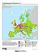
Anthropogenic Biomes of the World, v2 (1700)Anthropogenic BiomesTo provide information on anthropogenic transformation of the biosphere circa 1700 for global land use studies and research on human-environment interactions. |
|
Anthropogenic Biomes of the World, v2 (1800)Anthropogenic BiomesTo provide information on anthropogenic transformation of the biosphere circa 1800 for global land use studies and research on human-environment interactions. |
Anthropogenic Biomes of the World, v2 (2000)Anthropogenic BiomesTo provide information on anthropogenic transformation of the biosphere circa 2000 for global land use studies and research on human-environment interactions. |
|
Anthropogenic Biomes of the World, v2 (1900)Anthropogenic BiomesTo provide information on anthropogenic transformation of the biosphere circa 1900 for global land use studies and research on human-environment interactions. |
||
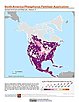
Population Count Grid, v1 (1990, 1995, 2000)Global Rural-Urban Mapping Project (GRUMP), v1To provide a time series of raster population data for ntegration with other data sets. |
||
Urban Extents Grid, v1 (1995)Global Rural-Urban Mapping Project (GRUMP), v1
To provide a raster representation of urban areas (or urban mask) for use with GRUMP population grids or other data sets. |
Land and Geographic Unit Area Grids, v1 (2000)Global Rural-Urban Mapping Project (GRUMP), v1To provide land area data for use with GRUMPv1 population and urban data as well as a quantitative measure of resolution of the input spatial units for GRUMPv1. |
|
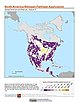
Population Density Grid, v1 (1990, 1995, 2000)Global Rural-Urban Mapping Project (GRUMP), v1
To provide a time series of raster population density data for data integration. |
National Identifier Grid, v1 (1995, 2000, 2010)Global Rural-Urban Mapping Project (GRUMP), v1To permit the summation of population values by country/territory and, in combination with other data layers, the summation of population values by irregular areas represented in the other data layers and country/territory. |
|
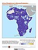
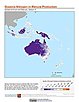
Annual Chlorophyll-a Concentration, v1 (
|
||
Global Flood Hazard Frequency and Distribution, v1 (
|
Global Landslide Mortality Risks and Distribution, v1 (2000)Natural Disaster Hotspots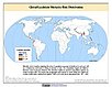
To provide a means of assessing global landslide mortality risks and distribution. |
|
Global Multihazard Total Economic Loss Risk Deciles, v1 (2000)Natural Disaster Hotspots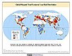
To identify areas of the world that are at greater risk of multihazard total economic loss. |
Global Multihazard Frequency and Distribution, v1 (2000)Natural Disaster Hotspots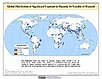
To provide insight into the frequency and distribution of multihazard events. |
| 2 of 4 |