Data Sets (47)
|
3 of 3
Prev
|
Next
|
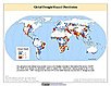
Global Flood Proportional Economic Loss Risk Deciles, v1 (2000)Natural Disaster Hotspots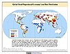
To provide a spatial surface of the proportional economic impacts of global flood hazard. |
Global Flood Mortality Risks and Distribution, v1 (2000)Natural Disaster Hotspots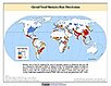
To provide a means of assessing global flood mortality risks and distribution. |
|
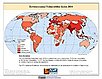
Global Earthquake Total Economic Loss Risk Deciles, v1 (2000)Natural Disaster Hotspots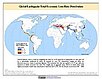
To provide a spatial surface of the total economic impacts of global earthquake hazard. |
Global Drought Hazard Frequency and Distribution, v1 (
|
|
U.S. Population Grids (Summary File 1): New Orleans Metropolitan Statistical Area, alpha (2000)Natural Disasters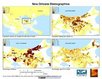
To provide gridded demographic data, including characteristics of age, race, ethnicity, and housing, for metropolitan statistical areas at a finer resolution than is available in the 30 arc-second grids used for the United States as a whole. |
U.S. Population Grids (Summary File 1): Houston Metropolitan Statistical Area, alpha (2000)Natural Disasters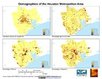
To provide gridded demographic data, including characteristics of age, race, ethnicity, and housing, for metropolitan statistical areas at a finer resolution than is available in the 30 arc-second grids used for the United States as a whole. |
|
Environmental Vulnerability Index (EVI), 2004 Release (
|
|
3 of 3
Prev
|
Next
|