Data Sets (157)
|
1 of 8
Prev
|
Next
|
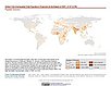
U.S. Climate Risk Projections by County, v1 (
|
SDG Indicator 7.1.1: Access to Electricity, 2023 Release (
|
|
SDG Indicator 11.2.1: Urban Access to Public Transport, 2023 Release (
|
SDG Indicator 9.1.1: The Rural Access Index (RAI), 2023 Release (
|
|
SDG Indicator 11.7.1: Urban Public Space, Availability and Access, 2023 Release (
|
U.S. Social Vulnerability Index Grids, v1.01 (2000, 2010, 2014, 2016, 2018, 2020)U.S. Census Grids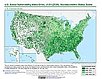
To provide a 1 km grid of the CDC Social Vulnerability Index (SVI) aligned with CIESIN's Gridded Population of the World, Version 4, Revision 11 (GPWv4.11) with a mask for water and no population. |
|
Global (GL) Annual PM2.5 Grids from MODIS, MISR and SeaWiFS Aerosol Optical Depth (AOD), v4.03 (
|
Water Security (WSIM-GLDAS) Monthly Grids, v1 (
|
|
Population, Landscape, And Climate Estimates (PLACE), v4 (2000, 2005, 2010, 2015, 2020)National Aggregates of Geospatial Data Collection (NAGDC)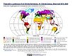
To provide tabular data to researchers without GIS capabilities who need data on population and land area by country across a range of physical characteristics. These include measures such as the number of persons living within coastal zones, the total area within a specific elevation strata, or the number of persons living within different climate zones. |
Global Gridded Relative Deprivation Index (GRDI), v1 (
|
|
Environmental Performance Index, 2022 Release (
|
Groundswell Spatial Population and Migration Projections at One-Eighth Degree According to SSPs and RCPs, v1 (
|
|
Geocoded Disasters (GDIS) Dataset, v1 (
|
Population (POP), Built-Up Estimates (BUILT), and Degree of Urbanization Settlement Model Grid (SMOD), v1 (1975, 1990, 2000, 2014, 2015)Global Human Settlement Layer (GHSL)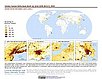
To provide global data on human population, built up area, and degree of urbanization for the years 1975, 1990, 2000, and 2014/2015 in the World Geodetic System 1984 (WGS84) geographic coordinate system. |
|
Global One-Eighth Degree Urban Land Extent Projection and Base Year Grids by SSP Scenarios, v1 (
|
Global Subnational Infant Mortality Rates, v2.01 (2015)Poverty Mapping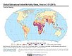
To provide a global subnational map of infant mortality rate estimates for the year 2015, to be used by a wide user community in interdisciplinary studies of health, poverty, and the environment. |
|
Urban-Rural Population and Land Area Estimates, v3 (1990, 2000, 2015)Low Elevation Coastal Zone (LECZ)
To provide estimates of urban and rural populations and land areas for the years 1990, 2000, 2015 for 234 countries and statistical areas with contiguous coastal elevations of less than or equal to 5m above sea level, 5-10m above sea level, and national totals using multiple updated data sources for comparative analysis. |
Global Pesticide Grids (PEST-CHEMGRIDS), v1.01 (2015, 2020, 2025)Global Agricultural Inputs, v1
To provide a global gridded data set of commonly-used agricultural pesticides crucial to assess human and ecosystem exposure to potential toxicants for environmental modeling, assessment of agricultural chemical contamination and risk analysis, and other related research at global, regional, national, and local levels. |
|
Global 1-km Downscaled Population Base Year and Projection Grids Based on the SSPs, v1.01 (
|
VIIRS Plus DMSP Change in Lights (VIIRS+DMSP dLIGHT), v1 (1992, 2002, 2013)Satellite-Derived Environmental Indicators
To visualize changes in brightness and extent of global nighttime lights networks over two decades with improved radiometric accuracy and finer spatial resolution. |


|
1 of 8
Prev
|
Next
|