Data Sets (14)
|
1 of 1
Prev
|
Next
|
U.S. Social Vulnerability Index Grids, v1.01 (2000, 2010, 2014, 2016, 2018, 2020)U.S. Census Grids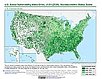
To provide a 1 km grid of the CDC Social Vulnerability Index (SVI) aligned with CIESIN's Gridded Population of the World, Version 4, Revision 11 (GPWv4.11) with a mask for water and no population. |
Global Gridded Relative Deprivation Index (GRDI), v1 (
|
|
Global Subnational Infant Mortality Rates, v2.01 (2015)Poverty Mapping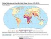
To provide a global subnational map of infant mortality rate estimates for the year 2015, to be used by a wide user community in interdisciplinary studies of health, poverty, and the environment. |
Global Human Modification of Terrestrial Systems, v1 (2016)Land Use and Land Cover
To provide a cumulative measure of human modification of terrestrial lands based on modeling the physical extents of 13 anthropogenic stressors and their estimated impacts using spatially-explicit global data sets. |
|
Global Development Potential Indices, v1 (2016)Land Use and Land Cover
To provide spatially-explicit data that relatively rank global land suitability referred to as Development Potential Indices (DPIs) for 13 sectors related to renewable energy, fossil fuels, mining and agriculture as an aid to conservation priority setting. |
Food Insecurity Hotspots Data Set, v1 (
|
|
Global Gridded Geographically Based Economic Data (G-Econ), v4 (1990, 1995, 2000, 2005)Spatial Economic Data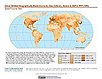
To provide global gridded Gross Domestic Product (GDP) data in both Market Exchange Rate (MER) and Purchasing Power Parity (PPP) to be used for socioeconomic, environmental, climate, and other related research. |
||
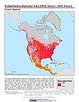
Dams, v1.01 (2011)Global Reservoir and Dam (GRanD), v1
To provide a geographically explicit and reliable database of dams for the scientific community. |
Reservoirs, v1.01 (2011)Global Reservoir and Dam (GRanD), v1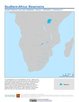
To provide a geographically explicit and reliable database of reservoirs for the scientific community. |
|
Small Area Estimates of Poverty and Inequality, v1 (
|
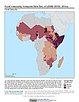
Global Subnational Prevalence of Child Malnutrition, v1 (
|
|
Global 15 x 15 Minute Grids of the Downscaled GDP Based on the SRES B2 Scenario, v1 (1990, 2025)Socioeconomic Downscaled Projections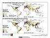
To provide gridded GDP data on country-level downscaled projections based on the SRES B2 marker scenario. |


|
1 of 1
Prev
|
Next
|