Data Sets (77)
|
1 of 4
Prev
|
Next
|
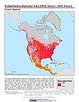
U.S. Climate Risk Projections by County, v1 (
|
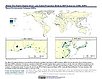
Groundswell Africa Spatial Population and Migration Projections at One-Eighth Degree According to SSPs and RCPs, v1 (
|
|
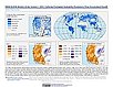
Annual Global High-Resolution Extreme Heat Estimates (GEHE), v1 (
|
Yale Center for Earth Observation (YCEO) Surface Urban Heat Islands, v4 (
|
|
U.S. Social Vulnerability Index Grids, v1.01 (2000, 2010, 2014, 2016, 2018, 2020)U.S. Census Grids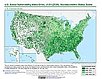
To provide a 1 km grid of the CDC Social Vulnerability Index (SVI) aligned with CIESIN's Gridded Population of the World, Version 4, Revision 11 (GPWv4.11) with a mask for water and no population. |
Global (GL) Annual PM2.5 Grids from MODIS, MISR and SeaWiFS Aerosol Optical Depth (AOD), v4.03 (
|
|
Water Security (WSIM-GLDAS) Monthly Grids, v1 (
|
Global Monthly and Seasonal Urban and Land Backscatter Time Series, v1 (
|
|
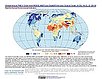
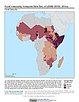
Global Gridded Relative Deprivation Index (GRDI), v1 (
|
Global One-Eighth Degree Urban Land Extent Projection and Base Year Grids by SSP Scenarios, v1 (
|
|
Global 1-km Downscaled Urban Land Extent Projection and Base Year Grids by SSP Scenarios, v1 (
|
Urban-Rural Population and Land Area Estimates, v3 (1990, 2000, 2015)Low Elevation Coastal Zone (LECZ)
To provide estimates of urban and rural populations and land areas for the years 1990, 2000, 2015 for 234 countries and statistical areas with contiguous coastal elevations of less than or equal to 5m above sea level, 5-10m above sea level, and national totals using multiple updated data sources for comparative analysis. |
|
Global Pesticide Grids (PEST-CHEMGRIDS), v1.01 (2015, 2020, 2025)Global Agricultural Inputs, v1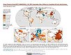
To provide a global gridded data set of commonly-used agricultural pesticides crucial to assess human and ecosystem exposure to potential toxicants for environmental modeling, assessment of agricultural chemical contamination and risk analysis, and other related research at global, regional, national, and local levels. |
Global Human Modification of Terrestrial Systems, v1 (2016)Land Use and Land Cover
To provide a cumulative measure of human modification of terrestrial lands based on modeling the physical extents of 13 anthropogenic stressors and their estimated impacts using spatially-explicit global data sets. |
|
Global Development Potential Indices, v1 (2016)Land Use and Land Cover
To provide spatially-explicit data that relatively rank global land suitability referred to as Development Potential Indices (DPIs) for 13 sectors related to renewable energy, fossil fuels, mining and agriculture as an aid to conservation priority setting. |
Food Insecurity Hotspots Data Set, v1 (
|
|
Development Threat Index, v1 (2015)Land Use and Land Cover (LULC)
To provide a future development threat map based on combining these resources: agricultural expansion, urban expansion, conventional oil and gas, unconventional oil and gas, coal, mining, biofuels, solar, and wind. |
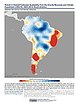
Trends in Global Freshwater Availability from the Gravity Recovery and Climate Experiment (GRACE), v1 (
|
|
Global Fire Emissions Indicators, Grids, v1 (
|

|
1 of 4
Prev
|
Next
|