Data Sets » Theme: WaterRemove Facet » Format: rasterRemove Facet
1 of 1
Prev | Next

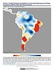
Groundswell Africa Spatial Population and Migration Projections at One-Eighth Degree According to SSPs and RCPs, v1 (2010 – 2050)

Climate Migration

To provide a data set that allows users to understand how climate change impacts on water availability, crop productivity, and pasturelands (where no cropping occurs), coupled with sea-level rise, storm surge and flooding, may affect the future population distribution and climate-related internal migration in West Africa and the Lake Victoria Basin.

Water Security (WSIM-GLDAS) Monthly Grids, v1 (1948 – 2014)

Water Resources

To provide data characterizing 67 years (1948-2014) of anomalous freshwater surpluses, deficits, and the parameters determining them, across the global terrestrial surface.

Trends in Global Freshwater Availability from the Gravity Recovery and Climate Experiment (GRACE), v1 (2002 – 2016)

Satellite-Derived Environmental Indicators

To provide data on changes in freshwater availability in order to better understand impacts on regional food supplies, human and ecosystem health, energy generation, and social unrest.

Data Quality Indicators, v4.11 (2010)

Gridded Population of the World (GPW), v4

To provide context for the population count and density rasters, and explicit information on the spatial precision of the input boundary data.

Land and Water Area, v4.11 (2010)

Gridded Population of the World (GPW), v4

To provide pixel-level land and water surface area estimates.

Croplands, v1 (2000)

Global Agricultural Lands

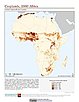
To provide data on the extent of croplands for research on human-environment interactions.

Ancillary Data, v1 (1998 – 2007)

Indicators of Coastal Water Quality

To provide data that can assist in the extraction and analysis of chlorophyll-a concentration and trends from global grids.

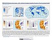
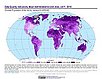
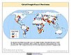
Global Flood Hazard Frequency and Distribution, v1 (1985 – 2003)

Natural Disaster Hotspots

To provide a means of assessing the relative distribution and frequency of global flood hazard.

Global Drought Total Economic Loss Risk Deciles, v1 (2000)

Natural Disaster Hotspots

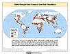
To provide a spatial surface of the total economic impacts of global drought hazard.

Global Drought Proportional Economic Loss Risk Deciles, v1 (2000)

Natural Disaster Hotspots

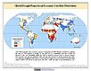
To provide a spatial surface of the proportional economic impacts of global drought hazard.

Global Drought Mortality Risks and Distribution, v1 (2000)

Natural Disaster Hotspots

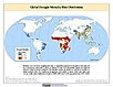
To provide a means of assessing global drought mortality risks and distribution.

Global Flood Total Economic Loss Risk Deciles, v1 (2000)

Natural Disaster Hotspots

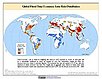
To provide a spatial surface of the total economic impacts of global flood hazard.

Global Flood Proportional Economic Loss Risk Deciles, v1 (2000)

Natural Disaster Hotspots

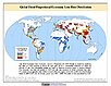
To provide a spatial surface of the proportional economic impacts of global flood hazard.

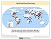
Global Flood Mortality Risks and Distribution, v1 (2000)

Natural Disaster Hotspots

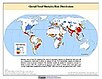
To provide a means of assessing global flood mortality risks and distribution.

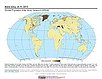
Global Drought Hazard Frequency and Distribution, v1 (1980 – 2000)

Natural Disaster Hotspots

To provide a means of assessing the relative distribution and frequency of global drought hazard.

MA Climate and Land Cover, v1 (1901 – 2000)

Millennium Ecosystem Assessment (MA)

To preserve access to the original climate and land cover data used by the Millennium Ecosystem Assessment (MA) and other related research.

MA Ecosystems, v1 (2000)

Millennium Ecosystem Assessment (MA)

To preserve access to the original ecosystems data used by the Millennium Ecosystem Assessment (MA) and other related research.

MA Biodiversity, v1 (1950 – 2001)

Millennium Ecosystem Assessment (MA)

To preserve access to the original biodiversity data used by the Millennium Ecosystem Assessment (MA) and other related research.

MA Scenarios, v1 (1995 – 2100)

Millennium Ecosystem Assessment (MA)

To preserve access to the original set of socioeconomic and natural resource scenarios used by the Millennium Ecosystem Assessment (MA) and other related research.

Data Sets » Theme: WaterRemove Facet » Format: rasterRemove Facet
1 of 1
Prev | Next