An online version of the annual American Geophysical Union (AGU) Fall Meeting brought together nearly 29,000 scientists and other experts for more than two weeks of online presentations, sessions, and exhibits December 1–17. CIESIN experts organized or co-chaired seven sessions and presented or co-authored twelve invited, oral, e-lightning, and poster papers, on a range of topics in multiple AGU tracks, including Global Change, Natural Hazards, Earth and Space Science Informatics, and Science and Society. Oral sessions included pre-recorded video talks of up to 15 minutes, combined with a one-hour live session with five-minute summaries and a moderated discussion. E-lightning sessions combined an online, interactive “iposter” with a one-hour live session with three-minute summaries and a discussion period. Posters consisted of an iposter made available for 24 hours within a designated visit period. This unique format enabled participation by scientists all over the world, albeit often at unusual hours of the day or night depending on time zones.
Alex de Sherbinin, associate director for Science Applications, presented an e-lightning paper on the Global COVID-19 Viewer, a mapping tool for data related to the coronovirus pandemic developed by the NASA Socioeconomic Data and Applications Center (SEDAC). Senior digital archivist Robert Downs gave two different e-lightning talks: “A Data Lifecycle Approach to Enabling Use by Capturing Data Provenance and Attribution” and “Advancing Open Data Sharing Across the Earth, Social, and Health Sciences for Pressing Societal Challenges.” CIESIN director Robert Chen presented the e-lightning paper, “Why People Matter: Better Data on Population and Infrastructure to Assess SDG Progress.”
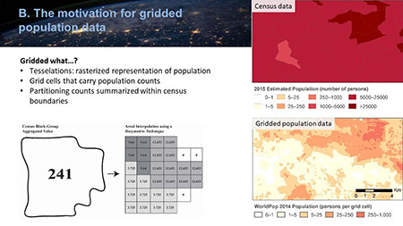
Cascade Tuholske, an Earth Institute Postdoctoral Fellow hosted by CIESIN, gave an oral paper, “Global Urban Population Exposure to Extreme Heat,” and an e-lightning presentation, “A Comparison of Gridded Population Data Products in Disaster Response.” Another CIESIN postdoctoral research scientist, Carolynne Hultquist, gave an oral presentation, “Developing Flood Risk Maps for Multi-Level Humanitarian Decision Making.”
Many CIESIN staff members were also co-authors on numerous papers given by colleagues from the Earth Institute or external partners such as the Earth Science Information Partners (ESIP), the German Climate Computing Centre (DKRZ), ImageCat Inc., ISciences LLC, and the United Nations Sustainable Development Solutions Network (SDSN). Chen, de Sherbinin, and Downs also convened and/or co-chaired multiple sessions on topics such as environmental intelligence, remote sensing applications in disaster management, trustworthy digital repositories, and open data sharing. Although the AGU′s online format limited the extent of informal networking and scientific discussion normally possible with an in-person conference, it did seem to allow wider participation from those who might otherwise not be able to attend, and generated a valuable set of prerecorded presentations and online posters that can be made available to a wider audience.