USA: Connecticut River Estuary and Tidal River
Wetlands Complex
By Ron Rozsa, Coastal
Ecologist, Office of Long Island Sound Programs
Connecticut Department of Environmental Protection
Web: http://dep.state.ct.us/olisp/ramsar/Connrivr.htm
1. Introduction
The lower Connecticut
River, beginning near its mouth and continuing upstream for a
distance of approximately 58 kilometers (36 miles), contains one
of the least developed or disturbed large-river tidal marsh systems
in the entire United States, and the most pristine large-river
tidal marsh system in the Northeast. From a regional standpoint,
there are no other areas in the Northeast that support such extensive
or high quality fresh and brackish tidal wetland systems as do
those in the Connecticut River estuary. These tidal river waters
and marshes provide essential habitat, not only for several federally-listed
and candidate species and globally rare species, including Bald
Eagle, shortnose sturgeon, Piping Plover, and Puritan tiger beetle,
but also for dozens of state-rare and endangered species. Waterfowl
concentrations in this section of the river, especially those
of American Black Duck, are among the highest and most significant
in the region. Several important restoration programs for anadromous
fish species, including Atlantic salmon and American shad, are
underway in the Connecticut River, especially at its mouth and
major tributary confluences with the mainstem.
Remote sensing using low
altitude aerial photography have been used to delineate submerged
aquatic vegetation (SAV) and the highly invasive grass, Phragmites
australis (i.e., non-native haplotype M). The objective for
SAV was to create a distribution maps and data regarding bed attributes
to establish a baseline which would support future trend analysis.
SAV is regarded as one of the best biological indicators of water
quality. Data on species abundance and distribution would also
permit monitoring for new invasive species and assessing trends
of existing non-native species such as Myriophyllum spicatum.
Phragmites is displacing the native emergent tidal wetland plant
communities, especially the brackish series, resulting in reduced
biodiversity, reduced structural diversity, increased breeding
by avian generalists and reduced breeding by avian marsh specialists.
The objectives of mapping Phragmites include creation of a baseline
for trend detection and setting restoration priorities of wetlands.
2. Description of results
The Connecticut Chapter of The Nature Conservancy did SAV mapping
through a grant from the Connecticut Department of Environmental
Protection's (DEP) Long Island Sound License Plate Grant. Low
altitude (1:12000) black and white aerial photography was acquired
in the summer of 1994 using NOAA's
Coastal Change Analysis Program protocols. Photointerpretation
was combined with extensive GPS (Trimble Pathfinder Pro XL) field
survey (1994 and 1995) to acquire bed boundaries and point location
data (i.e., dominant species, percent cover, species present,
salinity, water depth, sediment type). The photography was georeferenced
with Geographic Transformer software, Arcview shapefiles were
produced for bed boundaries and data point locations. An Arcview
Project was produced that allows the user to view the digital
aerial photographs, SAV boundaries and point data.
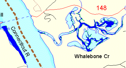
Figure 1. SAV beds for Whalebone Creek shown inblue.
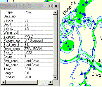
Figure 2. SAV beds (yellow) and sampling points (blue triangle).
Table generated using GetInfo button in Arcview. The dominant
SAV at the selected point is Potamogeton pectinatus (PPEC) which
had a percent cover of 10%. Associated SAV species include Zannichellia
palustris and Elodea canadensis.
Phragmites mapping was
done by Dr. Nels Barrett and Sandy Prisloe using the 1994 photography
described above and 1968 black and white low altitude (1:12000)
aerial photography. This project was funded through a grant from
DEP's Long Island Sound License Plate program. Stereo pairs were
used for the photointerpretation vegetation boundaries. Boundaries
and ground-control points were drawn in ink on mylar overlays.
The photographs and overlays were georeferenced. The bed boundaries
were screen digitized from the stereo-interpreted boundaries and
adjusted using the georeferenced images in the background using
ArcView software.
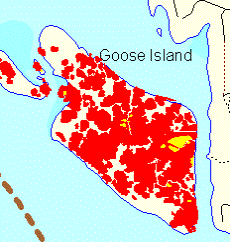
Figure 3. Areal extent of Phragmites in 1994 (red) versus
1968 (yellow).
3. Conclusions
Analysis of Phragmites
distribution data indicate that invasion is occurring at the fastest
rates in the mesohaline and oligohaline zones. Photointerpretation
of aerial photographs by Connecticut College scientists demonstrate
that Phragmites colonizes the creek banks first, this may be merely
a function of microlevees acting to trap flotsam containing seeds
and rhizome fragments. The general absence of this invasive grass
from the fresh-tidal marshes, especially the most upstream marshes
which experienced long periods of inundation during the spring
freshet, may be a function of the hydroperiod is too wet for the
survival of rhizome fragments. If the general absence of Phragmites
in upstream freshtidal marshes is merely the lack of sufficient
time to colonize the more interior marshes, periodic mapping of
the distribution of this grass may help to determine the role
of hydroperiod and time. If hydroperiod is truly a limiting factor
in certain areas, this might allow managers to invest limited
funds and restoration efforts to a smaller subset of marshes.
Where restoration activities are being implemented, future photointerpretation
can be used to evaluate the efficacy of control measures.
Remapping of SAV on the Connecticut River is the next step toward
assessing trends and identifying new management issues. A new
invasive aquatic plant has been found upstream in several tidal
and non-tidal waterbodies associated with the mainstem that has
the potential to become highly invasive in the Ramsar area. That
plant is water chestnut (Trapa natans). These populations have
been subjected to multi-year harvesting plan to eradicate existing
populations. There is no evidence yet that Trapa has become established
downstream. SAV remapping combined with field survey would be
helpful in identifying new populations and the need to implement
additional harvesting plans.
back to Case Studies Table