|
|
|
Pantanal Tri-National GIS and Remote Sensing
Pilot Project Case Study
for Bolivia, Brazil, and Paraguay
Montserrat Carbonell,
Ducks Unlimited, Inc.
on behalf of the Pantanal GIS Consortium (see Table
1)
Web: http://www.ducks.org/conservation/latinamerica.asp
I. Introduction
The completion of the
Pantanal Tri-national Pilot Project in October 2002 is the initial
step in the development of a comprehensive GIS and remote sensing
database for conservation planning and a data distribution network
for the Upper Paraguay River Basin (UPRB). The pilot area covers
the Otuquis in Bolivia (all of which is a newly designated Ramsar
site), the Nabileque in Brazil (which is soon to be designated
a Parque Estadual and a Ramsar site), and the Río Negro
in Paraguay (partly included in the Río Negro Ramsar site)
(Figures 1
and 2).
Partners from governmental and non-governmental (NGO) agencies
in Bolivia, Brazil, Paraguay and the United States have been collaborating
on remote sensing and spatial data development tasks. Remotely
sensed data was recognized as a vital application for studying
inaccessible or remote areas at a regional scale and for change
detection analysis. The data produced by the project will be used
to model the effects of past, current and future land-use practices
and to determine boundaries of future protected areas or prioritize
action for restoration in the UPRB.
The Pantanal is one of
the world's richest ecosystems. Due to its location in the center
of South America, it has fauna and flora typical of the Amazon,
Chaco, Cerrado, Dry Chiquitania Forest, and Atlantic Forest ecosystems,
which contribute to its high biological diversity. It includes
more than 300 species of birds, 190 species of fish, 70 species
of amphibians, and 50 species of large mammals (WWF 2002). It
is especially important for migratory birds and provides habitat
for populations of Giant River Otter, Marsh Deer, Tapir and Jaguar
that are at risk in the region and elsewhere in the world (WWF
2002). The Pantanal is the world's largest continuous freshwater
wetland, approximately the size of Honduras, Nicaragua and El
Salvador combined, with an estimated area of 150,000 km2 of which
110,000 km2 are wetland (Scott and Carbonell 1986). Its boundaries
extend across the borders of three countries: Bolivia, Brazil
and Paraguay, but more than 70 percent of the Pantanal is located
in Brazil (Dolabella 2000). All three countries protect discontinuous
areas of Pantanal under different protection regimes such as the
National Park Service, State Park Service and Forestry Reserves.
Some areas have also been designated as Ramsar sites under the
Convention on Wetlands of International Importance especially
as Waterfowl Habitat (henceforth Ramsar Convention). However,
much of this region is still unprotected and approximately 95
percent is under private ownership as cattle ranches (Crisman
2000). Primary threats to ecosystem health include road development
projects, frequent uncontrolled fires, river channeling, and large-scale
agriculture production, all of which can change the hydrology
and water quality of the region.
The challenge was to develop
common, landscape-level data sets for tri-national natural resource
planning. During the 7th Meeting of the Conference of the Contracting
Parties to the Ramsar Convention in Costa Rica (May 1999), Ducks
Unlimited. Inc. (DU) and the USDA Forest Service organized a Geographic
Information System (GIS) seminar to present DU's work with GIS
on wetland and watershed protection over the last 20 years. After
consultation with participating government agencies, research
institutions and individuals from the three countries, it became
apparent that there was no comprehensive GIS database in place
for the UPRB. Subsequently, a scoping meeting was held in Campo
Grande, Mato Grosso do Sul, Brazil in April 2000 with the objectives
of determining standards and guidelines for delivering a GIS and
remote sensing database, evaluating land-use and conservation
planning needs with natural resource management staff for the
region, identifying a pilot project area, establishing data priorities,
and formulating institutional partnerships.
Funded with seed money
from the USDA Forest Service International Program, the role of
DU has been one of facilitation and capacity building as well
as coordinating fundraising efforts. DU and the USDA Forest Service
are aware that a tri-national project can be complex and time
consuming, but the success of a project can only be guaranteed
in the long term if the direct users of the results are involved
and actively participating in the process.
The partnering organizations
holding project agreements and those who have been actively involved
in data development for the pilot project are listed alphabetically
by country in Table 1.
Table
1. Members of the Pantanal GIS Consortium
| Bolivia |
Brazil |
Paraguay |
USA/Canada |
| World Wildlife Fund (WWF Bolivia) |
Ecotrópica
Empresa Brasilera de Pesquisa
Agropecuaria (EMBRAPA) (agreement pending)
Fundação Estadual de Meio Ambiente (FEMA-MT)
Instituto Brasileiro do Meio Ambiente e
dos Recursos Naturais Renováveis (IBAMA) (agreement pending)
Instituto de Meio Ambiente Pantanal (IMAP-MS)
Universidade Católica Don Bosco (UCDB)
|
Fundación Moisés Bertoni (FMB)
Guyra Paraguay
|
Ducks Unlimited Inc
Ducks Unlimited Canada
Land Information and Computer Graphics
Facility, University of Wisconsin
University of Memphis
US Geological Survey
USDA Forest Service
|
2. Methods and Results
The first step in the study was to develop a change detection
analysis for the pilot area. One of the purposes of the change
detection analysis was to determine landscape level changes, both
natural and human-induced, for the Pantanal pilot project area
so cross-border analyses could be made and common methods could
be applied for planning, monitoring and managing the basin. In
the past, each country has completed many projects that have generated
important spatial information for the Upper Paraguay River Basin.
However, each used different classification schemes and a variety
of formats, even within their own country, making data sharing
and transfer extremely difficult. To counter this challenge, the
Pantanal Pilot GIS project partners decided to start with several
analyses that are important for conservation. Several approaches
were used to identify temporal change in the following areas:
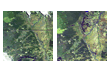
- Hydrology (Figure
3 & Figure
4)
- Seasonal Flooded Area/Water Level Changes (Max/Min flooded
area)
- Historical Land-Use and Land-Cover Change (Figure
5)
- Human-Induced (NDVI/Vegetation Change)
- Naturally Occurring (fires and regeneration) Burn Scars
- Roads Data Update (Figure
6)
The group also decided to use ERDAS Imagine image processing
software and ESRI's GIS products, including ArcView 3.2, ArcView
Spatial Analyst, ArcView Image Analysis to develop a long-term
solution that will unite the three countries in their desire to
protect and manage the Pantanal and the UPRB.
The use of Landsat TM (Thematic Mapper) and Landsat ETM+ (Enhanced
Thematic Mapper) satellite imagery was a logical choice for monitoring
and evaluating environmental threats in the pilot project area
(Figure
7) and eventually the entire Upper Paraguay River Basin for
the following reasons:
- Each image covers a large regional area (185 x
170 km).
- The 30 x 30 meter spatial resolution provides
sufficient detail for landscape studies
- Scenes are captured frequently and archived.
- Multi-spectral characteristics allow features
such as vegetation, moisture and inundation to be extracted
from the data.
- The use of this technology provided a cost-effective
method for landscape scale analysis.

Figure
7
Based on river gauge and
precipitation information gathered from several sources in South
America, Landsat TM and ETM+ scenes and dates were selected for
the pilot area. River height and/or discharge data was evaluated
to determine the optimal timing for the satellite imagery. The
Pantanal has widely variable water flooding regimes both seasonally
and annually within the basin. It is very important to understand
this variability when selecting imagery for change detection analysis.
Precipitation data is important for the same reasons. Timing of
rainfall in the pilot area sub-region must be well understood
to apply it to the selection of imagery.
The following imagery
dates were used for this study and represented high, medium, and
low water periods as well as high fire seasons:
- Landsat TM - November 23, 1988
- Landsat TM - June 9, 1997
- Landsat TM - July 7, 1998
- Landsat TM - November 19, 1998
- Landsat TM - December 24, 1999
- Landsat ETM+ - November 14, 1999
Utilizing ERDAS Imagine
and ESRI software, partners from Bolivia, Brazil, Paraguay and
the United States have been working together on image processing
and GIS data development tasks such as edge detection, normalized
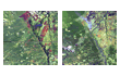
difference vegetation index (NDVI) differencing (Figure
8), flood extent analysis (Figure
9), multi-temporal burn scar data layers (Figure
10) and updating digital roads data. Satellite imagery and
aerial photography can also be used in conjunction with wildlife
surveys and other GIS feature data for habitat assessments. The
data produced by these assessments can be used to model the effects
of current and future land-use practices and determine, for example,
boundaries of future protected areas or areas of priority action
for management and restoration. It can also be used to make management
decisions at sub-catchment levels and it offers planners and decision-makers
the tools necessary to provide sustainable alternatives to development
projects.
As a result of coordinated
software training and brainstorming at various workshops and field
data collection efforts between and within the three countries,
the following pilot project deliverables were developed and presented
in draft format for review at a meeting in Cuiabá, Brazil
in August 2002:
- GIS data and satellite imagery inventory for the pilot area.
- An imagery-based change detection dataset depicting areas
with significant change in the last 10+ years (1) Seasonal Flood
Extent, (2) Vegetation/NDVI, (3) Multi-date burn scar data layers.
- Analysis and map production at a landscape level.
- Updated roads coverage for the pilot project portion in each
country.
- Land cover maps and other existing topographic maps for each
country have been compiled, reprojected and compiled as a mosaic
where scale and format permitted.
- Compilation of existing georeferenced historical aerial photography
for portions of the pilot area and acquisition of new aerial
photography with GPS coordinates for Bolivia, Paraguay and Brazil.
- Fieldwork producing ground control points (GCP's) for georeferencing
of imagery (Figure
11).
- Quality check of the data that has been conducted to ensure
that the three countries have compatible file formats, projections,
and attributes.
- A standardized metadata format has been completed for all
datasets.
- A report and power point presentation documenting procedures
and the contents of the database is in the final stages of development.
- A team of local organizations with GIS capacity in Bolivia,
Brazil, and Paraguay will continue to develop and maintain the
integrated database for the entire Upper Paraguay River Basin.

Figure 11
In addition to the above
contributions to the development of the Pantanal GIS database,
the project has also produced the following benefits:
- Establishment of a technical network of professionals, specialized
in GIS, remote sensing, and spatial data development;
- Development of a PantanalGIS email discussion list with more
than 200 members for posting messages and updates related to
the Pantanal GIS project and other projects related to the Pantanal;
- Building of alliances between institutions and countries sharing
stewardship of the Upper Paraguay watershed;
- Coordination and standardization of applications and procedures
among the three countries for the development, maintenance and
use of the comprehensive Upper Paraguay River Basin GIS database;
- The preliminary results of a proposed tri-national land cover
classification for the UPRB;
- The project has been documented in journals and newspapers
and presented at several professional meetings.
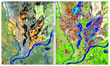
Initial findings show
that time-series NDVI and NDVI differencing appeared to produce
the best results for visually detecting landscape-scale, clear-cut
and burned areas in forest and heavily vegetated areas. A decrease
in the infrared coupled with an increase in red leads to a large
decrease in the calculated NDVI for a burn scar compared to that
of unburned vegetation. The rationale of this procedure is that
it highlights areas showing a change in time, normally associated
with fire damages and vegetation re-growth. The decorrelated data
produced through this process were of great value in enhancing
regions of localized change in NDVI.
Results of the pilot project
have prompted partners such as WWF in Bolivia, Guyrá in
Paraguay and EMBRAPA in Brazil to apply methods, data and/or results
of the pilot project to specific cases on the ground in each of
their countries. For example, extensive burn scars mapped from
1999 analyses in the Bolivian pilot area prompted discussions
with the Bolivian Park Service (Figure
12).

The completion of the
pilot project leads to the next phase of GIS database development
which includes (1) web-enabling the pilot project data inventory,
(2) expanding the project to other areas in the UPRB and (3) confirming
a location and organization responsible for establishing, maintaining
and serving the database. Satellite imagery will continue to play
an essential role in the development of key datasets and identifying
priority areas of monitoring, evaluation, and planning. At present,
a communication and dissemination strategy is being developed
to ensure that these data may be made available to both technicians
and planners. An effective way to share the pilot project results
and attract more users of the database is via the Internet. There
are three main Internet-based components:
- Create a Metadata (data description) Clearinghouse: This will
soon be served through the US Geological Survey site http://130.11.52.184/servlet/FGDCServlet
where the general public will have access;
- Develop a GIS data and literature inventory: A data inventory
and bibliography was compiled in Access at DU and will be served
via a web-enabled data catalogue created and maintained by Ducks
Unlimited, Canada. General public will soon have access; and
- Compile the database for ftp access and Internet: Develop,
test, and establish an initial central location for all project-related
GIS and imagery data and documents. Mirror sites may be developed
later. General public will soon have access.
3. Conclusions
The methods and standards
established during the pilot project will be transferred to the
broader Upper Paraguay River Basin Tri-National GIS project. The
image processing methods may vary slightly for each country depending
on software availability, landscape characteristics, hydrology,
and other factors that make various portions of the Pantanal unique.
We look forward to new partners joining the project and incorporating
new technical capabilities and software/hardware availability.
Many suggestions were made during the pilot project on how to
expand on some of the image processing and GIS tasks. Communication
between partners via meetings and the technical discussion list
will continue to be pivotal to the development of the project.
If your organization is interested in subscribing to the list
serve, please enroll via email at the following address: pantanalgis@yahoogroups.com.
The completion of the
pilot project leads to the next phase of GIS database development
that includes:
- Expanding the project to other areas in the Upper Paraguay
River Basin UPRB
- Web-enabling the pilot project data inventory for the general
public, and
- Confirming the location(s) and organization(s) responsible
for establishing, maintaining and serving the database.
4. References
Crisman, T. 2000. Wetland Ecotones and the Role of the Private
Sector in Conservation and Management of the Pantanal; Hudson
MacArthur Publishers. Available at http://www.pantanal.org/crisman.htm.
Dolabella, A.L. 2000. The Pantanal of Brazil, Bolivia, and Paraguay.
Hudson MacArthur Publishers, Waterland Research Institute.
Scott, D.A. and Carbonell, M. (1986) Directory of Neotropical
wetlands. IUCN, Cambridge and IWRB, Slimbridge, UK. 684 pp.
WWF, 2002. World Wildlife Fund. Living Waters Campaign Newsroom.
Bolivian Pantanal. Available at http://www.panda.org/livingwaters/fact3.htm.
back to Case Studies Table
|
|