South Africa: uKhahlamba Drakensberg Park and
the National Wetlands Inventory
by John Dini
Assistant Director, Biodiversity Planning
Department of Environmental Affairs and Tourism
Republic of South Africa
Web: http://www.ccwr.ac.za/wetlands
I. Introduction
uKhahlamba Drakensberg
Park (formerly Natal Drakensberg Park) was designated as a Ramsar
site on 21 January 1997, and features 242,813 ha of high altitude
tarns, springs, bogs, marshes and streams. The area is located
in eastern KwaZulu-Natal, along the border between the Province
of KwaZulu-Natal, South Africa and the Kingdom of Lesotho. Extensive
wetlands of various types occur within the rare Afro-alpine and
Afromontane belts. The Drakensberg is regarded as the most important
mountain catchment in South Africa because of the high water yield
and good quality water which flows from it. Marshes in the park
tend to occur in permanently waterlogged areas on very gentle
slopes or in depressions, and are characterized by various vegetation
types dominated by Cyperaceae and, to a lesser extent, Juncaceae.
The primary reason for
the establishment of the uKhahlamba Drakensberg Park was to ensure
the maintenance and production of quality water for the country's
needs. The South African Department of Water Affairs and Forestry
have implemented a water scheme to pump water out of KwaZulu-Natal
to the densely populated and highly industrialised Gauteng Province
in the interior of the country. The Park attracts thousands of
visitors annually both from South Africa and overseas who make
use of caves, public campsites and mountain huts for overnight
visits.
The original objectives for using remote sensing were to:
- prepare an inventory of the wetlands of the uKhahlamba
Drakensberg Park according to the Ramsar wetland descriptors;
- evaluate the effectiveness of using satellite imagery as
a preliminary mapping tool to determine the location, the
extent, and the features or characteristics of the wetlands;
- investigate the feasibility of classifying wetlands based
on satellite imagery; and
- develop a mapping, inventory and monitoring procedure for
the wetlands of the uKhahlamba Drakensberg Park, which would
be applicable on a national scale in the context of a National
Wetlands Inventory.
2. Description of methods and results
The project evaluated
several types of imagery, including SPOT, Russian satellite, Landsat
MSS and TM imagery, and ultimately selected Landsat TM imagery
from September 1991 for the analysis. Landsat TM, provides a reasonably
quick and cost-effective means for mapping wetlands. In South
Africa, the imagery is generally available for all areas and has
a good historical archive. This allows the most appropriate images
to be selected and seasonal differences to be analyzed. The repeatability
of satellite-based mapping, in terms of both the availability
of archived imagery and the frequency with which new imagery is
acquired, makes this method well suited to on-going monitoring
of wetlands.
Despite the advantages
of Landsat TM, this imagery was not considered adequate for mapping
the wetlands of the uKhahlamba Drakensberg Park to a high level
of accuracy. As a result of the constraints imposed by the resolution
of the imagery, wetlands over one hectare (100 m2) in size could
be detected with 90 percent accuracy, but those under that threshold
could generally not be detected. Research has shown that an object
must be 54 m across before its radiance can be accurately detected,
thus indicating that the minimum size of a detectable object is
larger than the 30 m resolution of Landsat imagery (Townshend
and Justice 1988). In these highland areas, with many seasonal
and temporary marshes and hill slope seepage wetlands, there are
many wetlands under the one hectare threshold. Transformed wetlands
were also not consistently detected, as a result of mixed spectral
signatures.
Mapping of wetlands using
satellite imagery is essentially limited to a generic "presence
and absence" mapping of "core" wetland areas, where
the identified wetlands are primarily defined by temporal surface
vegetation characteristics rather than more permanent sub-surface
soil profiles. This is an important consideration in the climate
of South Africa, with important seasonal and interannual precipitation
variability, since in some years wetlands may be much wetter than
in others. In these circumstances, the direct presence of water,
surface vegetation conditions, or permanently saturated soils
are often unreliable indicators of wetland conditions or boundaries,
with the result that wetlands will not always exhibit obvious
spectral signatures.
The proposed solution
for the national wetland inventory is to combine Landsat imagery
in a GIS with digital elevation model (DEM), hydrological and
land use data. The final wetland delineation will be achieved
by combining a DEM-derived Landscape Wetness Potential (LWP) model
with the image-derived spectral wetland classification, in order
to modify the spatial distribution of the spectrally defined wetlands
according to terrain-defined wetness potential classes. A second
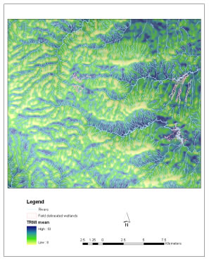
model, termed the Topographic Relative Moisture Index (TRMI),
is an index, which combines relative slope position, slope configuration,
slope steepness and slope aspect into a single scalar value (accumulative
range from 0 to 60). It will also be used to assist in identifying
potential wetland areas. Both are illustrated for two wetland
areas which, like uKhahlamba Drakensberg Park, are located in
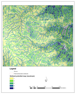
the highlands of KwaZulu-Natal Province (see Figure 1). Figure
2 illustrates the proposed final products, developed through a
larger pilot project to develop methods for the for the national
wetland inventory (Wetlands Inventory Consortium 2002).
Figure
1. (a) Landscape Wetness Potential (LWP) and (b) Topographic
Relative Moisture Index (TRMI) for High Moor and Kamberg study sites
in Kwazulu/Natal Province. (Source: Wetlands Inventory Consortium,
A Methodology Proposed for a South African National Wetland Inventory,
March 2002.)

Figure
2
3. Conclusions and next steps
This pilot effort at uKhahlamba
Drakensberg Park yielded useful results in terms of testing approaches
for South Africa's national wetland inventory. Based on these
results, and the recommendations of the pilot project for the
national wetlands inventory, a phased approach will be followed.
The first stage of the inventory will be integrated into the National
Land Cover 2000 project, which is a satellite-based national 1:50,000
scale baseline inventory of current land cover and land use. Although
the resulting spatial wetland data will have limitations in terms
of the accuracy of boundary delineations and under-representation
of small and transformed wetlands, it will nonetheless provide
a highly cost-effective and quick means of generating a national
overview of the country's wetlands.
Subsequent phases of the
inventory will utilize the spatial data generated through the
National Land Cover project as a baseline from which to undertake
more detailed mapping in priority catchments and Ramsar sites.
It is likely that aerial photography will be utilized, in order
to produce the required detail and accuracy.
4. References
Dely JL, Kotze DC, Quinn
NW and Mander JJ. 1999. A pilot project to compile and inventory
and classification of wetlands in the Natal Drakensberg Park.
Department of Environmental Affairs and Tourism. Pretoria
Townshend JRG and Justice
CO, 1988. Selecting the spatial resolution of satellite sensors
required for global monitoring of land transformations. International
Journal of Remote Sensing 1988, Vol. 9, No 2, pp 187-236.
Wetlands Inventory Consortium,
2002. A Methodology Proposed for a South African National Wetland
Inventory, Report prepared for Wetlands Conservation Programme,
Department Environmental Affairs and Tourism, Republic of South
Africa, March 2002.</p>
back
to Case Studies Table