Marine and Coastal Regions and Sea Level Rise
|
2 of 2
Prev
|
Next
|
Demographic and Health Survey Data Sets, v1 (
|
Gridded Subset of Sub-national Poverty and Extreme Poverty Prevalence, v1 (2005)West Africa Coastal Vulnerability MappingTo provide poverty levels in the coastal zone of West Africa. |
|
Deforestation, v1 (
|
Subset of DMSP-OLS Nighttime Lights for Economic Activity, v1 (2010)West Africa Coastal Vulnerability MappingTo provide a measure of economic activity in the coastal zone of West Africa based on nighttime lights. |
|
Commercial Crop Production, v1 (2000)West Africa Coastal Vulnerability MappingTo provide crop production for five higher-value export crops in West Africa to aid in estimating production value. |
Economic Systems Index, v1 (2000, 2010)West Africa Coastal Vulnerability MappingTo assess relative levels of economic activity in the coastal zone of West Africa. |
|
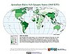
Point and Gridded Locations of Fatalities, v1 (
|
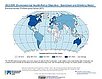
Environmental Performance Index, 2020 Release (
|
|
Environmental Performance Index, 2010 Release (
|
Environmental Performance Index and Pilot Trend Environmental Performance Index, 2012 Release (
|
|
Environmental Performance Index, 2014 Release (
|
Environmental Performance Index, 2016 Release (
|
|
Environmental Performance Index, 2018 Release (
|
Environmental Performance Index, 2008 Release (
|
|
Environmental Performance Index, 2022 Release (
|
U.S. Social Vulnerability Index Grids, v1.01 (2000, 2010, 2014, 2016, 2018, 2020)U.S. Census Grids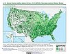
To provide a 1 km grid of the CDC Social Vulnerability Index (SVI) aligned with CIESIN's Gridded Population of the World, Version 4, Revision 11 (GPWv4.11) with a mask for water and no population. |
|
Fifth Assessment Report (AR5) Observed Climate Change Impacts, v2.01 (
|
Fourth Assessment Report (AR4) Observed Climate Change Impacts, v1 (
|
|
Complete Collection, v1.01 (
|
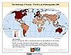
The Wellbeing of Nations, v1 (
|
|
2 of 2
Prev
|
Next
|