Satellite-Derived Environmental Indicators
To provide an annual global surface of concentrations (micrograms per cubic meter) of mineral dust and sea-salt filtered fine particulate matter of 2.5 micrometers or smaller (PM2.5) in countries and urban areas for large-scale health and environmental research
|
|
Satellite-Derived Environmental Indicators

To provide a global data set of average summer daytime maximum/nighttime minimum land surface temperatures (LSTs) for urban extents, as well as the LST difference between the urban area and the buffer.
|
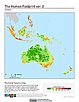
Last of the Wild, v2
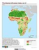
To provide an updated map of anthropogenic impacts on the environment in geographic projection which can be used in wildlife conservation planning, natural resource management, and research on human-environment interactions.
|
|
Last of the Wild, v2
To provide an updated map of anthropogenic impacts on the environment in Interrupted Goode Homolosine Projection which can be used in wildlife conservation planning, natural resource management, and research on human-environment interactions.
|
Last of the Wild, v2
To provide an updated map of anthropogenic impacts on the environment in the Interrupted Goode Homolosine Projection which can be used in wildlife conservation planning, natural resource management, and research on human-environment interactions.
|
|
Last of the Wild, v2
To provide an updated map of wild areas in geographic projection which can be used in wildlife conservation planning, natural resource management, and research on human-environment interactions.
|
Last of the Wild, v2
To provide an updated map of anthropogenic impacts on the environment in geographic projection which can be used in wildlife conservation planning, natural resource management, and research on human-environment interactions.
|
|
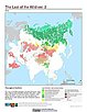
Last of the Wild, v2
To provide an updated map of wild areas in Interrupted Goode Homolosine Projection which can be used for wildlife conservation planning, natural resource management, and research on human-environment interactions.
|