Gridded Population of the World (GPW) Version 1
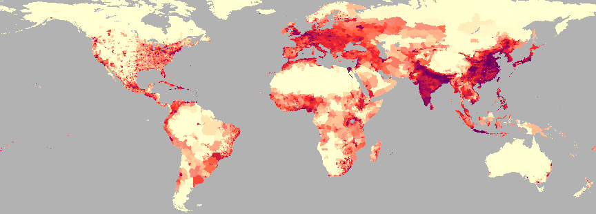
 Smoothed Population Density
 Unsmoothed Population Density
Note: The data and information on this page refer to Gridded Population of the World Version 1 (GPW v1) released in 1995.
Please go to http://sedac.ciesin.columbia.edu/gpw/ to get the most recent version of GPW.
Dataset Abstract/Summary
Demographic information is usually provided on a national basis. But we know that countries are ephemeral phenomena. As an alternate scheme one might use ecological zones rather than nation states. But there is no agreement as to what these zones should be. By way of contrast global environmental studies using satellites as collection devices yield results indexed by latitude and longitude. Thus it makes sense to assemble the terrestrial arrangement of people in a compatible manner. This alternative is explored here, using latitude/longitude quadrilaterals as bins for population information. This data format also has considerable advantage for analytical studies.
For additional information, please see National Center for Geographic Information and Analysis (NCGIA) Technical Report TR-95-6
Dataset Variables
There are four files in this dataset. Each file contains one variable. The variables are:
- population counts (i.e., the number of people in each 5' x 5' cell), unsmoothed
- with the file name gpxxx or countrawxxx
- population density (i.e., people per square kilometer), unsmoothed
- with the file name gppdxxx or densrawxxx
- global population (counts, smoothed)
- with the file name gppycxxx or countsmooxxx
- global population (population density, smoothed)
- with the file name gppycpdxxx or denssmooxxx
The data are available as ASCII files or as pkzip compressed ArcInfo Export files. The ArcInfo Export files are in three formats:
- ArcInfo GRID, 0.083 x 0.083 degree cell size (GRIDDD).
- ArcInfo GRID, 5 x 5 minute cell size (GRIDDM).
- ArcInfo polygon format, created from GRIDDM (POLYDM).
The GRIDDD files are the original files. The GRIDDM are files created to get around certain problems that occur with these data when used with certain ArcInfo processes. The POLYDM files are for use with ArcView or for other polygon based GIS packages.
Each format is available as a global coverage, or as one of five subsets: North and Central America, Latin America and the Caribbean, Africa and Europe, Asia, and Australia, New Zealand, and Oceania.
Archival and Access Information
GPW v1 is archived and distributed by the Socioeconomic Data and Applications Center (SEDAC) and is available via ftp at http://www.ciesin.columbia.edu/datasets/gpw/ftpgrid.html. More recent versions of GPW are available at http://sedac.ciesin.columbia.edu/gpw/.
Data Acquisition/Collection Summary
These data were collected and compiled by NCGIA staff. The data were processed using ArcInfo and ERDAS. For additional details, please see NCGIA Technical Report TR-95-6.
Further Information
For further information please contact SEDAC User Services.

 Unsmoothed Population Density