Argentina: Esteros del Ibera
By Dr. Steven Loiselle
Researcher
University of Siena, Dept. of Chemical and Biosystem Sciences
Web: http://www.unisi.it/wetland
1. Introduction
The Lagunas y Esteros
del Iberá is a Ramsar site that was designated on 18 January
2002. The site itself is 24,550 hectares in size, but the associated
wetland complex covers more than 12,000 square kilometers, or
one-seventh of the Argentine province of Corrientes. The Esteros
is one of the last large wetland ecosystems in South America that
has remained significantly unmodified by human activities. This
inland rain- and groundwater-fed wetland is located between three
large rivers, the Rio Paranà alto, the Rio Paranà
medio and the Rio Uruguay. There is no surface connection to the
rivers, with the exception of the outlet to the Rio Corrientes
that feeds into the Parana Medio.
The wetland consists of
a vast mosaic of marshes, swamps and lagoons, of which nearly
60 percent are permanently inundated. The interrelation between
permanently and seasonally flooded wetland ecosystems supports
a diversified community of wildlife typical of subtropical seasonal
savannahs.
This remote sensing study
was conducted for habitat mapping, wetland delineation, and to
determine water optical quality and water quality. Funding for
the study was provided by the European Commission's International
Cooperation Fourth Framework Programme.
2. Methods and results
The study utilized a total
of 40 images from Landsat TM and ETM, and SAC-C MMRS (an Argentine
sensor), acquired between the dates of February 1998 and February
2002. A series of satellite image was used to determine a distribution
of particular habitats and to analyze the changes in land use
and characteristics over a 15 year period. These images were made
available by the Argentine Commission on Space Activities (CONAE)
as part of the SAC-C mission. Habitat definition was carried out
using field data and a simulated SAC-C image (175 m. spatial resolution).
The definition of habitats was based on homogeneous polygons which
were defined in the field through the use of GPS data, field observations
and location of vegetation censuses on a topographic map. Seven
habitat types were defined, including permanent lagoons, open
marsh areas (esteros), temporary marsh areas (malezales or bañados)
and four types of consolidated floating mats of vegetation (embalsados).
The examination of a temporal series of images demonstrated that
significant changes have occurred inland use in the last two decades.
The SAC-C time series
images were of great importance in the study of the distribution
of vegetation and water characteristics of the wetland. Satellite
data was also used to study the change in land use and the possible
hydrological changes that have occurred in the wetland after the
construction of the nearby hydroelectric facility (see Figure
1). Field measurements and satellite measured radiances were compared
to examine the spatial and seasonal variation of the available
habitat and the optical characteristics of the shallow lake water
bodies. Furthermore, a land use classification of the border areas
was made to determine the changes in land use and the wetland
overall extension using satellite data. A long term monitoring
plan was created through the continued collaboration with CONAE
to continue to monitor the vegetation and water quality.
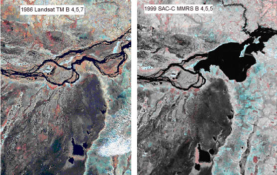
Figure
1 - The northern part of the Esteros del Ibera wetland, with
the Parana river to the north. The two dates (1986 at left, and
1999 at right) show the impact of the construction of the Yacyreta
Hydroelectric facility on the Parana river and the creation of
the large artificial reservoir, directly above the wetland.
For the water quality
monitoring, standard correction techniques (including dark pixel)
were used to obtain reflectances, these were correlated to onsite
measurements of water optical properties. This information was
then tested and extended to other parts of the wetland. The time
series data showed seasonal variations in water quality, which
demonstrated hydrological impacts of small rivers on the wetland
(Figure 2). This analysis helped to establish general observations
on the possible influences of agricultural activities on the water
quality.
The remotely sensed data
were also combined in a GIS with land use maps, ecological data
related to key species, and limnological data on water quality.
The imagery helped to show the extent and characteristics of an
extensive wetland area to local and regional audiences. Finally,
the data were used for various modeling purposes.
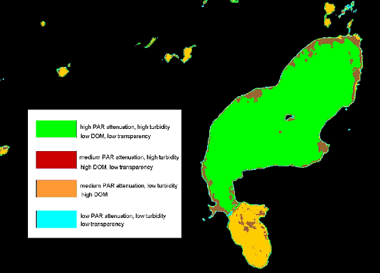
Figure
2 - Spatial variation of optical water quality parameters based
on reflectance based algorithms (ETM) for a single date in November
2001. The study lake is the Laguna Ibera, in the Esteros del Ibera
wetland, Corrientes Argentina. Four classes of water are characterized
based on a knowledge-based classification using transparency,
turbidity, attenuation coefficient for photosynthetic available
radiation (PAR) and dissolved organic matter concentrations. Vegetated
wetland areas and agricultural areas have been masked out.
3. Conclusions
Due to the extensive nature
and remoteness of the Esteros del Ibera wetland, remote sensing
techniques were found to be fundamental in the study of the wetland,
in particular the vegetation and water characteristics and their
spatial distribution. By the same token, however, ground truthing
over a significant part of the wetland area was nearly impossible,
due to its remoteness and lack of infrastructure.
The Esteros del Ibera
are continuing to be monitored as part of a long term monitoring
project, in collaboration with the Argentine Space Agency. More
information is available through the above-referenced web site.