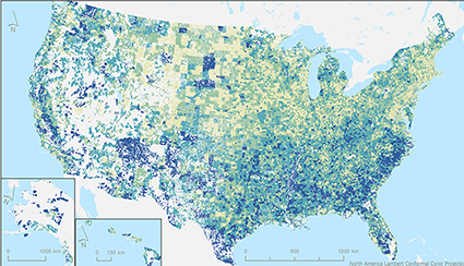
NASA Website Socioeconomic Data and Applications Center (sedac)
A Data Center in NASA's Earth Observing System Data and Information System (EOSDIS) — Hosted by CIESIN at Columbia University
Data
  • Data Sets
  • Maps
  • Web Pages
  • home
  • Data
    • · Data Sets
    • · Data Collections
    • · Featured Data Uses
    • · Data Citations
    • · Citations Database
  • Maps
    • · Map Gallery
    • · Map Viewer
    • · Map Services
    • · Mapping Tools
  • Themes
    • · Agriculture
    • · Climate
    • · Conservation
    • · Governance
    • · Hazards
    • · Health
    • · Infrastructure
    • · Land Use
    • · Marine and Coastal
    • · Population
    • · Poverty
    • · Remote Sensing
    • · Sustainability
    • · Urban
    • · Water
  • Resources
    • · Guides
    • · Multimedia
    • · Networks
    • · News
    • · Publications
    • · Related Sites
    • · Remote Sensing
    • · Tools
  • Social Media
    • · Twitter
    • · FaceBook
    • · YouTube
    • · Flickr
    • · Blog Posts
    • · Communities
  • About
    • · About SEDAC
    • · User Working Group
    • · Privacy
    • · User Registration
  • Help
 

Hazards and Disaster Risk

Follow Us: Twitter Follow Us on Facebook YouTube Flickr   |   Share: Twitter Facebook
  • Theme Home
  • Data Sets
  • Map Gallery
  • Map Services
  • Featured Data Uses
  • Resources
    • Guides
    • Multimedia
    • Networks
    • News
    • Related Sites
1 of 1
Prev | Next
 

NASA Highlights Remote Sensing Data Use by CIESIN Scientist

May 30, 2018
photo of Pinki Mondal at her workstation

Credit: Chandranath Basak

CIESIN senior research associate Pinki Mondal has been featured in a NASA Earthdata user profile published online May 24. The user profile is part of a regular series about users of NASA earth science data. Mondal combines remotely-sensed data with census and other data to study the effects of climate change on agricultural systems and communities. Her current research focuses on smallholder farms in tropical countries that can be especially vulnerable to climate variability and to impacts from socioeconomic factors such as urbanization and government policies. She utilizes microwave satellite data, Synthetic Aperture Radar (SAR) data, and high-resolution optical satellite data from a variety of sources to help characterize land use/land cover changes over time in relationship to climate and other factors.

For the NASA Socioeconomic Data and Applications Center (SEDAC) operated by CIESIN, Mondal has had lead responsibility for establishing the India Data Collection, which currently consists of the India Village-Level Geospatial Socio-Economic Data Set:1991, 2001 and the India Annual Winter Cropped Area, v1 (2001–2016). She also led development of the Global Summer Land Surface Temperature (LS) Grids, v1, and helped develop the Global Urban Heat Island (UHI) Data Set, v1 (2013), as well as other SEDAC data sets.

In August, Mondal will begin a position as assistant professor in the Department of Geography at the University of Delaware in Newark, Delaware.

See:
  • NASA Earthdata User Profile

Lamont Campus Scientists Promote Environmental Awareness at Local Earth Day Fair

April 18, 2018

As part of festivities worldwide celebrating Earth Day, CIESIN participated in a fair at St. Thomas Aquinas College (STAC) in Sparkill, New York, April 17, co-hosted by STAC and Columbia University′s Lamont-Doherty Earth Observatory. The free event, held for the third year, was attended by both undergraduate and K-12 students and  educators, together with members of the general public. Senior research staff assistant Alyssa Fico coordinated CIESIN’s participation in the event, with the assistance of geographic information specialist Linda Pistolesi, staff associate Emilie Schnarr, and CIESIN director Robert Chen. They demonstrated the Hazards Mapper and HazPop mobile app developed by the NASA Socioeconomic Data and Applications Center operated by CIESIN. They also engaged attendees in an interactive data gathering exercise using online geographic information system (GIS) software to locate nearby areas of interest such as eateries, parks, and schools. The fair featured environmental science projects conducted by STAC students as well as a range of hands-on science education activities offered by other scientists from around the Lamont campus.

Displacement from Sea Level Rise Addressed at Annapolis Workshop

April 3, 2018

Alex de Sherbinin, CIESIN associate director for Science Applications, participated in a National Socio-Environmental Synthesis Center (SESYNC) Pursuit event March 28–29 that focused on populations displaced by sea level rise and coastal extremes. The workshop was hosted by the University of Maryland in Annapolis and led by David Wrathall of Oregon State University and Valerie Mueller of Arizona State University. Twenty researchers from a variety of academic and government institutions in the United States and abroad were invited to participate. Funded by a grant from the U.S. National Science Foundation, SESYNC facilitates interdisciplinary collaborations to develop data-driven solutions to socio-environmental issues.

See:
  • SESYNC Project Description: "A forecast of the timing, locations, sequence and likeliest destinations of populations displaced by sea level rise and coastal extremes"

Map Viewer Tutorial Now Available on YouTube Web Site

January 8, 2010

TerraViva! SEDAC Viewer is a map viewer and standalone software application that uses a powerful data-viewing engine and tools to enable the visualization and integration of hundreds of socioeconomic and environmental variables and layers, including a range of satellite-based data. A three-part tutorial that explains how to use TerraViva! is now available through the YouTube Web site. The tutorial was produced by senior research associate Alex de Sherbinin and senior media designer Al Pinto, under the auspices of the NASA Socioeconomic Data and Applications Center (SEDAC) operated by CIESIN.

See:
  • TerraViva! SEDAC Viewer Map Tutorial
  • Terra Viva! SEDAC Viewer order form
1 of 1
Prev | Next
 

Home | Data | Data Uses | Data Citations | Maps | Map Services

News | Tools | Guides | Publications | Blog Posts

About | Help | Privacy | User Registration

Copyright © 1997–2019. The Trustees of Columbia University in the City of New York.

WDS ICSU