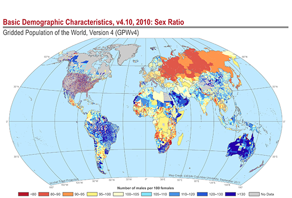
The most recent update to the fourth version of the Gridded Population of the World data collection, GPW version 4.10, contains the first global data set on the spatial distribution of population broken down into different age groups by sex (male and female). The data were developed by the NASA Socioeconomic Data and Applications Center (SEDAC) operated by CIESIN.
Prior versions of GPW provided estimates of the total population in each latitude-longitude grid cell. Now with the inclusion of age and sex information drawn from the 2010 round of national population censuses, it is possible to map specific demographic subgroups such as elderly populations, school-aged children, young adults, and women of childbearing age. This enables users to better understand spatial variations in age structure and sex ratios within countries for specific regions of interest. The age and sex data expand GPW’s usefulness in many research and application areas, including vulnerability and risk mapping, urbanization and migration studies, and emergency response and public health applications. In addition, gridded age and sex data can help in monitoring and achieving the Sustainable Development Goals (SDGs), especially with respect to efforts to disaggregate data to support the objective to “leave no one behind,” e.g., the elderly, the young, and other subgroups who may be geographically isolated.
The new downloadable data consist of population counts and density rasters for 5-year age groups and for selected age categories (0–14, 15–64, 65 and older), as totals and by sex. A raster data set of women of childbearing age (15–49) is also available. All of the GPWv4.10 raster data sets are now available in ASCII and netCDF formats as well as GeoTiff. Files with coarser resolution (2.5, 15, 30, and 60 arc minutes) may be selected to enable faster raster processing and compatibility with data sets from other scientific domains. A vector data set, “Administrative Unit Center Points,” has been updated to include age and sex attributes.
First developed in 1994, GPW provides population estimates on a latitude-longitude grid for all land on the planet except Antarctica, created through analysis of census and administrative boundary data from every country in the world. The gridded format permits easy integration with a wide range of data, supporting research, planning, and applications in energy and water management, disaster and humanitarian response, agriculture and food security planning, public health interventions, transportation and communications development, urban and coastal zone planning, and many other aspects of sustainable development.
The free, downloadable data and descriptions, including documentation and maps, are available at http://sedac.ciesin.columbia.edu/data/collection/gpw-v4/whatsnewrev10. The data are disseminated using the Creative Commons Attribution 4.0 International (CC-BY-4.0) license, which permits free sharing, adaptation, and use of the data for both commercial and noncommercial purposes, so long as appropriate credit is given.