Hazards and Disaster Risk
|
3 of 3
Prev
|
Next
|
Annual Global High-Resolution Extreme Heat Estimates (GEHE), v1 (
|
U.S. Social Vulnerability Index Grids, v1.01 (2000, 2010, 2014, 2016, 2018, 2020)U.S. Census Grids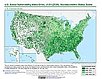
To provide a 1 km grid of the CDC Social Vulnerability Index (SVI) aligned with CIESIN's Gridded Population of the World, Version 4, Revision 11 (GPWv4.11) with a mask for water and no population. |
|
ATSDR Hazardous Waste Site Polygon Data, v2 (2010)Superfund Site FootprintsTo provide the ATSDR polygon data set of hazardous waste sites in the United States, Puerto Rico, and other territories which can be used to identify nearby populations and assess their potential risk. |
ATSDR Hazardous Waste Site Polygon Data with CIESIN Modifications, v2 (2010)Superfund Site FootprintsTo provide an easily accessible, corrected data set of polygons for hazardous waste sites in the United States which can be used to identify nearby populations and assess their potential risk. |
|
U.S. EPA National Priorities List Sites with CIESIN Modifications, v2 (2014)Superfund Site Footprints
To provide an easily accessible, corrected EPA data set of the geo-referenced locations displayed as points for all the National Priorities List (NPL) Superfund sites in the United States, Puerto Rico, and other territories. |
Global Gridded Relative Deprivation Index (GRDI), v1 (
|
|
Global Urban Heat Island (UHI) Data Set, v1 (2013)Satellite-Derived Environmental Indicators
To provide a global data set of average summer daytime maximum/nighttime minimum land surface temperatures (LSTs) for urban extents, as well as the LST difference between the urban area and the buffer. |
Global Summer Land Surface Temperature (LST) Grids, v1 (2013)Satellite-Derived Environmental Indicators
To provide raster representations of global summer daytime maximum and nighttime minimum surface temperature for studies related to human health and climate change. |
|
SSPs Literature Database, v1 (
|
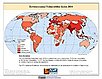
Environmental Vulnerability Index (EVI), 2004 Release (
|
|
Complete Collection, v1.01 (
|
Yale Center for Earth Observation (YCEO) Surface Urban Heat Islands, v4 (
|
|
Sub-global Scenarios that Extend the Global SSP Narratives: Literature Database, v1 (
|
U.S. Population Grids (Summary File 3): Alabama, Louisiana, and Mississippi, alpha (2000)Natural DisastersTo provide gridded demographic data, including characteristics of income, poverty, education, and housing age, for Alabama, Louisiana and Mississippi. |
|
U.S. Population Grids (Summary File 1): New Orleans Metropolitan Statistical Area, alpha (2000)Natural Disasters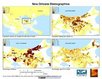
To provide gridded demographic data, including characteristics of age, race, ethnicity, and housing, for metropolitan statistical areas at a finer resolution than is available in the 30 arc-second grids used for the United States as a whole. |
U.S. Population Grids (Summary File 1): Houston Metropolitan Statistical Area, alpha (2000)Natural Disasters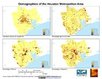
To provide gridded demographic data, including characteristics of age, race, ethnicity, and housing, for metropolitan statistical areas at a finer resolution than is available in the 30 arc-second grids used for the United States as a whole. |
|
U.S. Population Grids (Summary File 1): Alabama, Louisiana, Mississippi and Texas, alpha (2000)Natural DisastersTo provide gridded demographic data, including characteristics of age, race, ethnicity, and housing, for Alabama, Louisiana, Mississippi and Texas. |
Development Threat Index, v1 (2015)Land Use and Land Cover (LULC)
To provide a future development threat map based on combining these resources: agricultural expansion, urban expansion, conventional oil and gas, unconventional oil and gas, coal, mining, biofuels, solar, and wind. |
|
3 of 3
Prev
|
Next
|