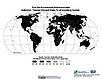
Global Agricultural Inputs, v1
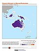
To provide nitrogen in manure production data that can be used in socioeconomic and ecological modeling and to explore anthropogenic activities on ecosystems.
|
|
Global Roads
To provide an open access, well documented global data set of roads between settlements using a consistent data model (UNSDI-T v.2) which is, to the extent possible, topologically integrated.
|
Environmental Sustainability Index (ESI)
To create a comparative index of national-level environmental sustainability and to provide a mechanism for making environmental management more quantitative, empirically grounded and systematic.
|
|
Millennium Ecosystem Assessment (MA)
To preserve access to the original ecosystems data used by the Millennium Ecosystem Assessment (MA) and other related research.
|
Last of the Wild, v1
To provide a map of anthropogenic impacts on the environment in geographic projection which can be used in modeling efforts, wildlife conservation planning, natural resource management, policy-making, biodiversity studies and human-environment interactions.
|
|
Last of the Wild, v1
To provide a map of the wildest areas in Interrupted Goode Homolosine Projection which can be used in wildlife conservation planning, natural resource management, and research on human-environment interactions.
|
Last of the Wild, v1
To provide a map of anthropogenic impacts on the environment in the Interrupted Goode Homosoline Projection which can be used in wildlife conservation planning, natural resource management, and research on human-environment interactions.
|
|
Last of the Wild, v1
To provide a map of wild areas in the Interrupted Goode Homolosine Projection which can be used in wildlife conservation planning, natural resource management, and research on human-environment interactions.
|
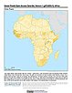
Last of the Wild, v1
To provide a map of the wildest areas in geographic projection which can be used in wildlife conservation planning, natural resource management, and research on human-environment interactions.
|
|
Last of the Wild, v1
To provide a map of wild areas in geographic projection which can be used in wildlife conservation planning, natural resource management, and research on human-environment interactions.
|
Environmental Sustainability Index (ESI)
To provide a comparative index of national-level environmental sustainability covering a number of sustainability dimensions.
|
|
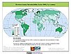
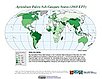
Environmental Performance Index (EPI)
To provide quantitative metrics for evaluating a country's environmental performance in different policy categories relative to clearly defined targets.
|
Environmental Sustainability Index (ESI)
To provide a comparative index of national-level environmental sustainability based on lessons learned from the year 2000 pilot effort.
|
|
Environmental Sustainability Index (ESI)
To test the feasibility of creating a comparative index of national-level environmental sustainability.
|
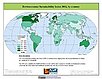
Environmental Performance Index (EPI)
To provide quantitative metrics for evaluating a country's environmental performance in different policy categories relative to clearly defined targets.
|
|
Environmental Performance Index (EPI)
To provide quantitative metrics for evaluating a country's environmental performance in different policy categories relative to clearly defined targets.
|