Health and the Environment
|
3 of 3
Prev
|
Next
|
Environmental Performance Index, 2018 Release (
|
Environmental Performance Index, 2008 Release (
|
|
Complete Collection, v1.01 (
|
||
Environmental Performance Index, 2022 Release (
|
U.S. Social Vulnerability Index Grids, v1.01 (2000, 2010, 2014, 2016, 2018, 2020)U.S. Census Grids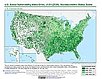
To provide a 1 km grid of the CDC Social Vulnerability Index (SVI) aligned with CIESIN's Gridded Population of the World, Version 4, Revision 11 (GPWv4.11) with a mask for water and no population. |
|
SSPs Literature Database, v1 (
|
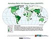
Global Roads Open Access Data Set (gROADS), v1 (
|
|
Sub-global Scenarios that Extend the Global SSP Narratives: Literature Database, v1 (
|
Annual Chlorophyll-a Concentration, v1 (
|
|
Change in Chlorophyll-a Concentration, v1 (
|
Environmental Sustainability Index, 2002 Release (
|
|
Environmental Sustainability Index, 2005 Release (
|
Chinese County-Level Data on Hospitals and Epidemiology Stations, v1 (
|
|
Ancillary Data, v1 (
|
U.S. Population Grids (Summary File 3): New Orleans Metropolitan Statistical Area, alpha (2000)Natural DisastersTo provide gridded demographic data, including characteristics of income, poverty, education, and housing age, for New Orleans. |
|
Global Gridded Relative Deprivation Index (GRDI), v1 (
|
Development Threat Index, v1 (2015)Land Use and Land Cover (LULC)
To provide a future development threat map based on combining these resources: agricultural expansion, urban expansion, conventional oil and gas, unconventional oil and gas, coal, mining, biofuels, solar, and wind. |
|
3 of 3
Prev
|
Next
|