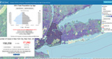
This global map viewer shows the number of people affected by the COVID-19 pandemic down to the U.S.-county level, and provides data on age and sex groups that can help identify populations most at risk.
April 28, 2020
This global map viewer shows the number of people affected by the COVID-19 pandemic down to the U.S.-county level, and provides data on age and sex groups that can help identify populations most at risk.
October 25, 2019
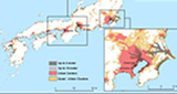
We contributed to a report that identifies urban populations at risk from sea level rise, leveraging a major data collection, the Low Elevation Coastal Zone.
February 26, 2019
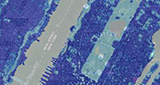
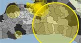
Two data products and a companion visualization tool released through the NASA Socioeconomic Data and Applications Center operated by CIESIN, provide data on man-made impervious surfaces and urban extents throughout the world, in greater detail than previously available.
February 7, 2018
To what degree do so-called “green” countries depend on the import of goods and services from countries considered more polluting? To help answer this question, CIESIN associate director for Science Applications Alex de Sherbinin and senior research associate Valentina Mara developed a Green Imports Index (GII) that builds on the 2018 Environmental Performance Index, to evaluate whether wealthy countries receive high scores at the expense of rapidly industrializing developing countries.
April 5, 2017
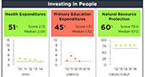
For more than a decade, SEDAC has updated the Natural Resource Protection Indicator and Child Health Indicator data annually for the Millennium Challenge Corporation, a grant-making arm of the U.S. government. This data collection supports the goals of the U.S. Millennium Challenge Corporation by providing data to develop selection criteria for low-income countries’ eligibility for development funding.
May 3, 2016
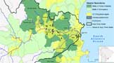
Risks for the world’s Transboundary River Basins are projected to increase in the next 15–30 years, particularly in four hotspot regions: the Middle East, Central Asia, the Ganges-Brahmaputra-Meghna basin, and the Orange and Limpopo basins in Southern Africa. Transboundary river basins cross international borders and are shared by two or more countries, which often makes managing them more challenging. A major report on the status and future threats to the world’s 286 transboundary river basins, funded by the Global Environmental Facility’s Transboundary Waters Assessment Program, has been released by a consortium of institutions led by the UNEP-DHI Center for Water and Environment, including the Earth Institute’s Center for International Earth Science Information Network (CIESIN).
March 24, 2016
In this blog post for the International Council for Science (ICSU) World Data System (WDS), Alex de Sherbinin, CIESIN associate director for science applications and a member of the WDS Scientific Committee, describes how the American Customer Satisfaction Index (ACSI) survey is an important performance metric for the NASA Distributed Active Archive Centers, of which SEDAC is one.
June 11, 2015
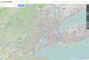
OpenStreetMap has had impressive growth in coverage and detail in the decade since its launch, and is increasingly being seen as an authoritative data source, much as Wikipedia has rivaled traditional encyclopedias for content and currency.
May 8, 2015

A recent report coordinated by the Sustainable Development Solutions Network estimates the world will need to spend roughly $1 billion a year to sustain and enhance the statistical systems.
May 6, 2015
A new Web-based mapping platform that integrates the Global Population of the World data may help G7+ states manage these resources strategically and sustainably, to accelerate growth and development.
March 24, 2015

The data revolution and the promise and limitations of Big Data.
March 18, 2015
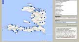
When the earthquake hit Haiti in 2010, much of the little data that existed was destroyed. A team at Tufts University went into action, and from afar, helped build updated maps of roads and earthquake damage to help humanitarian organizations deal with the crisis.
September 3, 2014
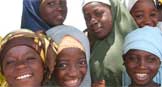
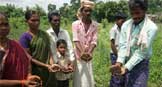
In Nigeria, differences in adolescent literacy rates between states are striking—higher in the South and lower in the Northeast.
June 2, 2014
Thanks to a collaboration between the Earth Institute and Haiti’s government, a registry of every government office is accessible online and via mobile devices.
April 4, 2014
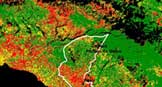
Studying the Pedernales Watershed, located along Haiti’s southern national boundary with the Dominican Republic, may provide insights into the stark contrast in land cover patterns between the two countries.
April 2, 2014
Among the key findings of the WGII AR5 Report chapter on human security, a topic highlighted in the Report for the first time, is that societies in conflict are more vulnerable to climate change.
March 7, 2014
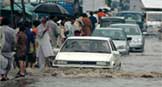
Biophysical and socioeconomic risk factors—such as terrain, population distribution, settlement patterns, poverty, and governance—can combine to produce high levels of vulnerability to heavy rainfall, flooding, and landslides.
March 6, 2014

Many resettlers are economically better off, but the dislocations remain significant.