Anthropogenic Biomes
Methods
This collection includes the Anthropogenic Biomes of the World, v1, and Anthropogenic Biomes of the World, v2 (with year 1700, 1800, 1900, 2000 versions). These are described separately.
Anthropogenic Biomes of the World, v1
A detailed description of the methods utilized to produce the data, as well as research results, are described in Ellis and Ramankutty (download PDF). Anthropogenic biomes were identified and mapped using a multi-stage procedure based on population (urban, non-urban), land use (percent area of pasture, crops, irrigation, rice and urban land) and land cover (percent area of trees and bare earth). Input datasets include population data (Landscan 2005), land use data (percent area under cropland, pasture, irrigation and rice) and land cover (vegetation, continuous fields, tree cover, and bare earth proportion layers).
Figure 1. Global Map of Anthropogenic Biomes
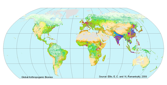
The multi-stage procedure began by first separating “anthropogenic” cells from “wild” cells based on presence of population, crops, or pastures. The anthropogenic cells were then stratified into population density classes: namely “dense”, “residential”, “populated” and “remote” based on the density of their non-urban population. Then cluster analysis was used to identify natural groupings within each of the strata identified above. Finally the clusters derived above were labeled, and organized into logical groupings, based on their populations, land-use and land-cover characteristics, and their regional distribution, yielding the 18 anthropogenic biome classes and three wild biome classes.
Anthropogenic Biomes of the World, v2 (1700, 1800, 1900, 2000 versions).
Anthropogenic Biomes of the World, v1 (which is called Anthromes version 1 by its authors) represents the first classification of globally significant ecological patterns created by humans. The data set classification used statistical methods (two-step cluster analysis) to identify and map anthromes using global data for human population density, land use and land cover, resulting in an empirical classification consisting of 21 anthrome classes, three of them wild. Anthropogenic Biomes of the World, v2 (which is called Anthromes version 2 by its authors) is based on the patterns identified in version 1, but simplified to 19 anthrome classes (2 of them wild) and classifies anthromes based on human population density and land use data using standard rules that allow consistent classification across time periods.
While the Anthropogenic Biomes of the World, v1 classes are more strongly linked to empirical analysis of global data, making them more objective, their identification cannot be made consistent across datasets (their identities are optimized to the data itself), so Anthromes v2 classification (or another similar method) is required to facilitate analysis of historical changes in the biosphere.
Acknowlegements
The original work on Anthropogenic Biomes of the World, v1 (2001-2006) was published in:
Ellis, E.C. and Ramankutty, N., (2008) Putting people in the map: Anthropogenic biomes of the world. Frontiers in Ecology and the Environment, 6(8): 439-447.
The original work on the Anthropogenic Biomes of the World, v2 (1700, 1800, 1900, 2000) data sets was published in:
Ellis, E.C., Goldewijk, K. K., Siebert, S., Lightman, D. and Ramankutty, N. (2010) Anthropogenic transformation of the biomes, 1700 to 2000. Global Ecology and Biogeography, 19: 589-606, DOI:10.1111/j.1466-8238.2010.00540.x
SEDAC would like to acknowledge Drs. Ellis and Ramankutty for providing these data for distribution. More information and original data on Anthromes are at: http://ecotope.org/anthromes/