NASA Website Socioeconomic Data and Applications Center (sedac)
A Data Center in NASA's Earth Observing System Data and Information System (EOSDIS) — Hosted by CIESIN at Columbia University
Data
  • Data Sets
  • Maps
  • Web Pages
  • home
  • Data
    • · Data Sets
    • · Data Collections
    • · Featured Data Uses
    • · Data Citations
    • · Citations Database
    • · Data Submission
  • Maps
    • · Map Gallery
    • · Map Viewer
    • · Map Services
    • · Mapping Tools
  • Themes
    • · Agriculture
    • · Climate
    • · Conservation
    • · Governance
    • · Hazards
    • · Health
    • · Infrastructure
    • · Land Use
    • · Marine and Coastal
    • · Population
    • · Poverty
    • · Remote Sensing
    • · Sustainability
    • · Urban
    • · Water
  • Resources
    • · Guides
    • · Multimedia
    • · Networks
    • · News
    • · Publications
    • · Related Sites
    • · Remote Sensing
    • · Tools
  • Social Media
    • · Twitter
    • · FaceBook
    • · YouTube
    • · Flickr
    • · Blog Posts
    • · Communities
  • About
    • · About SEDAC
    • · User Working Group
    • · Privacy
    • · User Registration
  • Help
 

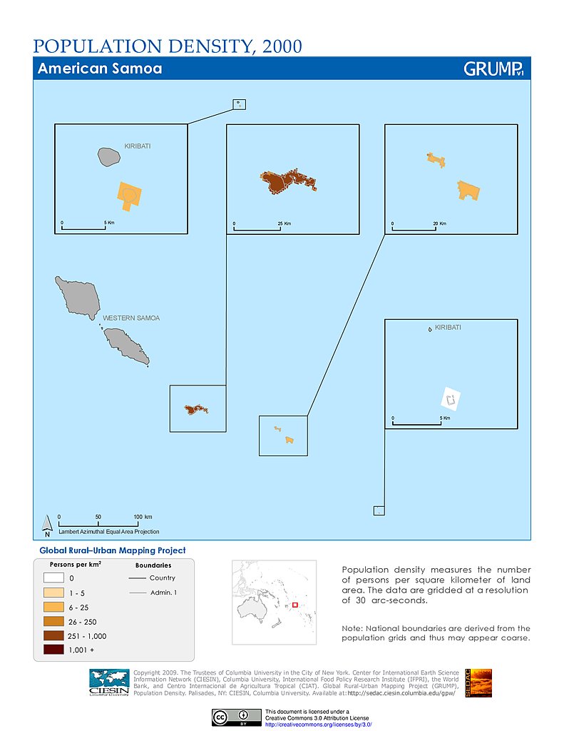
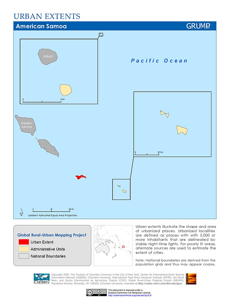
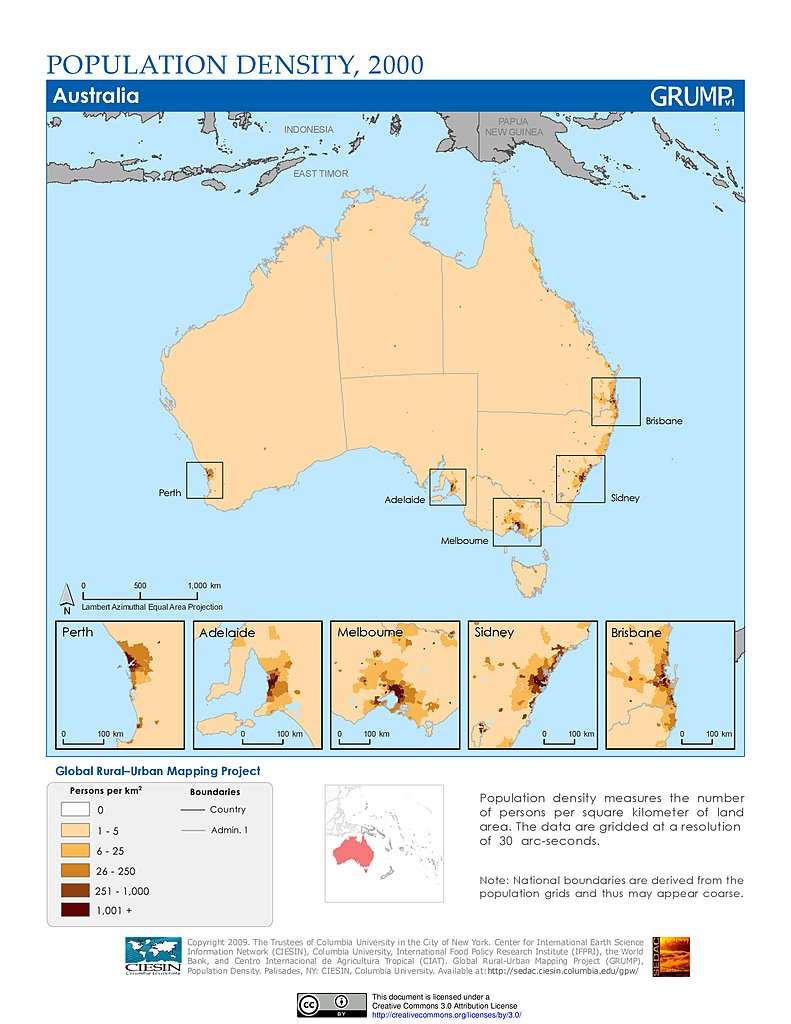
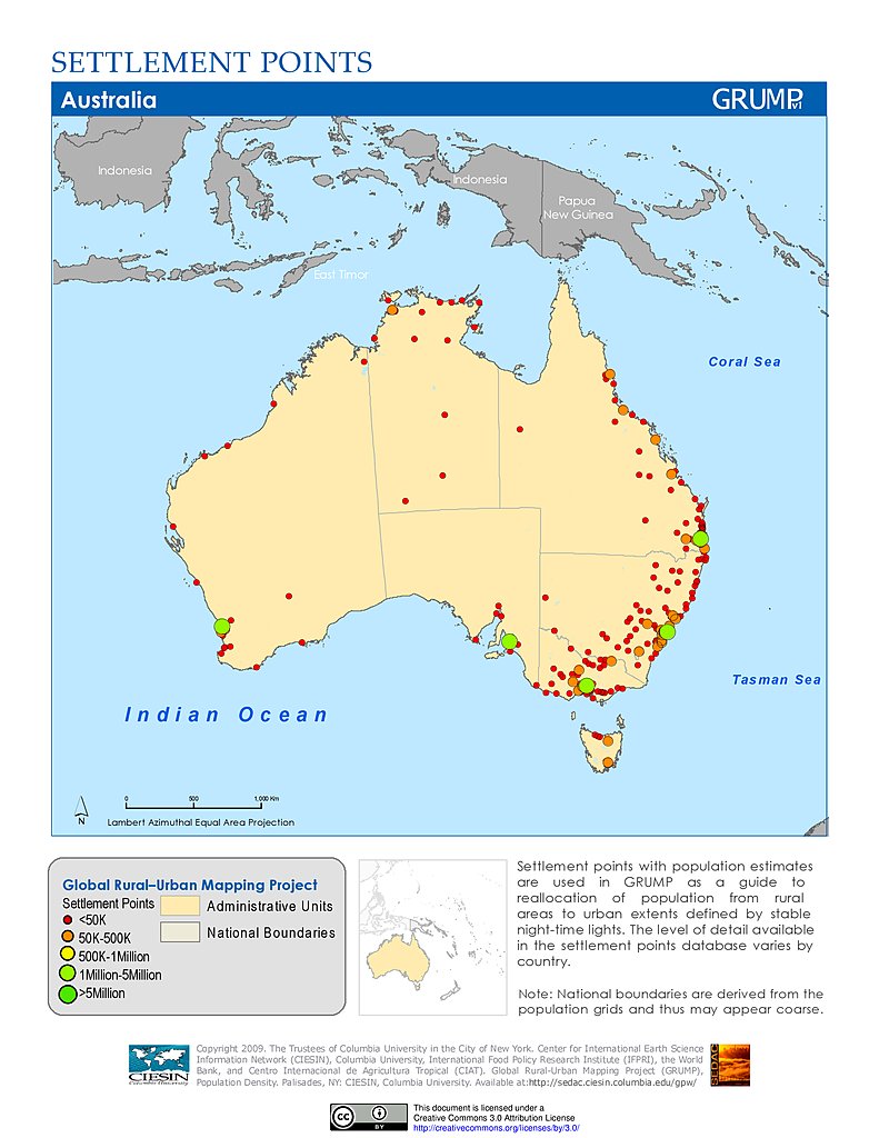
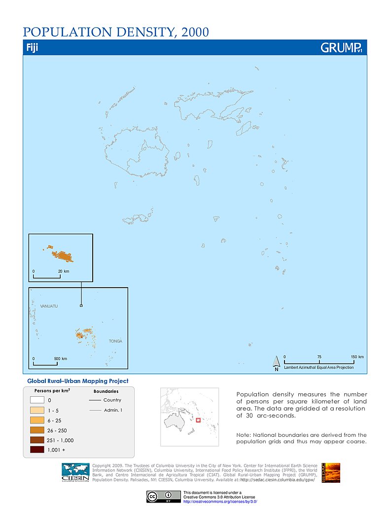
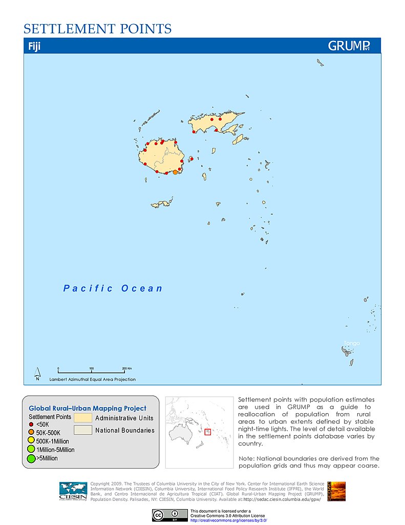
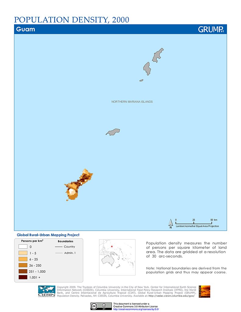
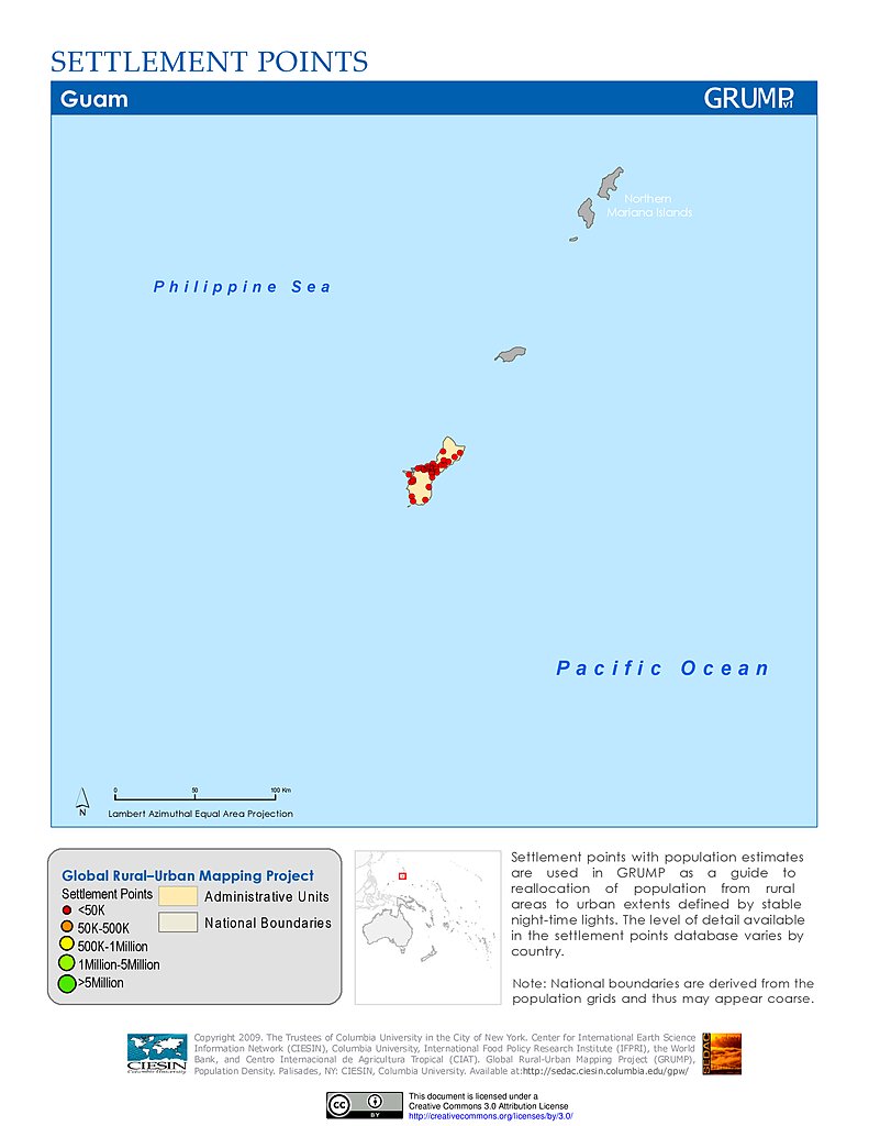
Global Rural-Urban Mapping Project (GRUMP), v1

Follow Us: Twitter Follow Us on Facebook YouTube Flickr   |   Share: Twitter Facebook
  • Collection Overview
  • Methods
  • Data Sets (10)
  • Map Gallery (716)
    Search
    Theme
    Population (81)
    Sustainability (81)
    Urban (81)
    Location
  • Map Services (10)
  • Citations
  • FAQs
  • GPW and GRUMP
  • Acknowledgments
  • SEDAC Hazards Mapper
Data Sets » Region: OceaniaRemove Facet
1 of 3
Prev | Next

Population Density (2000): American Samoa

Map: Population Density (2000): American Samoa
Hi-Resolution: PDF | PNG

Settlement Points: American Samoa

Map: Settlement Points: American Samoa
Hi-Resolution: PDF | PNG

Urban Extents: American Samoa

Map: Urban Extents: American Samoa
Hi-Resolution: PDF | PNG

Population Density (2000): Oceania

Map: Population Density (2000): Oceania
Hi-Resolution: PDF | PNG

Settlement Points: Oceania

Map: Settlement Points: Oceania
Hi-Resolution: PDF | PNG

Urban Extents: Oceania

Map: Urban Extents: Oceania
Hi-Resolution: PDF | PNG

Population Density (2000): Cook Islands

Map: Population Density (2000): Cook Islands
Hi-Resolution: PDF | PNG

Settlement Points: Cook Islands

Map: Settlement Points: Cook Islands
Hi-Resolution: PDF | PNG

Urban Extents: Cook Islands

Map: Urban Extents: Cook Islands
Hi-Resolution: PDF | PNG

Population Density (2000): Fiji

Map: Population Density (2000): Fiji
Hi-Resolution: PDF | PNG

Settlement Points: Fiji

Map: Settlement Points: Fiji
Hi-Resolution: PDF | PNG

Urban Extents: Fiji

Map: Urban Extents: Fiji
Hi-Resolution: PDF | PNG

Population Density (2000): French Polynesia

Map: Population Density (2000): French Polynesia
Hi-Resolution: PDF | PNG

Settlement Points: French Polynesia

Map: Settlement Points: French Polynesia
Hi-Resolution: PDF | PNG

Urban Extents: French Polynesia

Map: Urban Extents: French Polynesia
Hi-Resolution: PDF | PNG

Population Density (2000): Guam

Map: Population Density (2000): Guam
Hi-Resolution: PDF | PNG

Settlement Points: Guam

Map: Settlement Points: Guam
Hi-Resolution: PDF | PNG

Urban Extents: Guam

Map: Urban Extents: Guam
Hi-Resolution: PDF | PNG

Population Density (2000): Kiribati

Map: Population Density (2000): Kiribati
Hi-Resolution: PDF | PNG

Settlement Points: Kiribati

Map: Settlement Points: Kiribati
Hi-Resolution: PDF | PNG

Urban Extents: Kiribati

Map: Urban Extents: Kiribati
Hi-Resolution: PDF | PNG

Population Density (2000): Marshall Islands

Map: Population Density (2000): Marshall Islands
Hi-Resolution: PDF | PNG

Settlement Points: Marshall Islands

Map: Settlement Points: Marshall Islands
Hi-Resolution: PDF | PNG

Urban Extents: Marshall Islands

Map: Urban Extents: Marshall Islands
Hi-Resolution: PDF | PNG

Population Density (2000): Micronesia

Map: Population Density (2000): Micronesia
Hi-Resolution: PDF | PNG

Settlement Points: Micronesia

Map: Settlement Points: Micronesia
Hi-Resolution: PDF | PNG

Urban Extents: Micronesia

Map: Urban Extents: Micronesia
Hi-Resolution: PDF | PNG

Population Density (2000): Nauru

Map: Population Density (2000): Nauru
Hi-Resolution: PDF | PNG

Settlement Points: Nauru

Map: Settlement Points: Nauru
Hi-Resolution: PDF | PNG

Urban Extents: Nauru

Map: Urban Extents: Nauru
Hi-Resolution: PDF | PNG

Population Density (2000): New Caledonia

Map: Population Density (2000): New Caledonia
Hi-Resolution: PDF | PNG

Settlement Points: New Caledonia

Map: Settlement Points: New Caledonia
Hi-Resolution: PDF | PNG
Data Sets » Region: OceaniaRemove Facet
1 of 3
Prev | Next

Home | Data | Data Uses | Data Citations | Maps | Map Services

News | Tools | Guides | Publications | Blog Posts

About | Help | Privacy | User Registration

Copyright © 1997–2021. The Trustees of Columbia University in the City of New York.

WDS ICSU