NASA Website Socioeconomic Data and Applications Center (sedac)
A Data Center in NASA's Earth Observing System Data and Information System (EOSDIS) — Hosted by CIESIN at Columbia University
Data
  • Data Sets
  • Maps
  • Web Pages
  • home
  • Data
    • · Data Sets
    • · Data Collections
    • · Featured Data Uses
    • · Data Citations
    • · Citations Database
    • · Data Submission
  • Maps
    • · Map Gallery
    • · Map Viewer
    • · Map Services
    • · Mapping Tools
  • Themes
    • · Agriculture
    • · Climate
    • · Conservation
    • · Governance
    • · Hazards
    • · Health
    • · Infrastructure
    • · Land Use
    • · Marine and Coastal
    • · Population
    • · Poverty
    • · Remote Sensing
    • · Sustainability
    • · Urban
    • · Water
  • Resources
    • · Guides
    • · Multimedia
    • · Networks
    • · News
    • · Publications
    • · Related Sites
    • · Remote Sensing
    • · Tools
  • Social Media
    • · Twitter
    • · FaceBook
    • · YouTube
    • · Flickr
    • · Blog Posts
    • · Communities
  • About
    • · About SEDAC
    • · User Working Group
    • · Privacy
    • · User Registration
  • Help
 

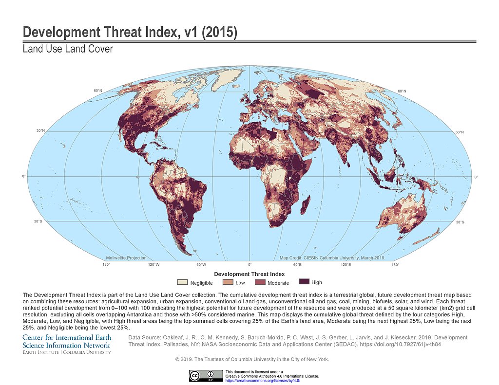
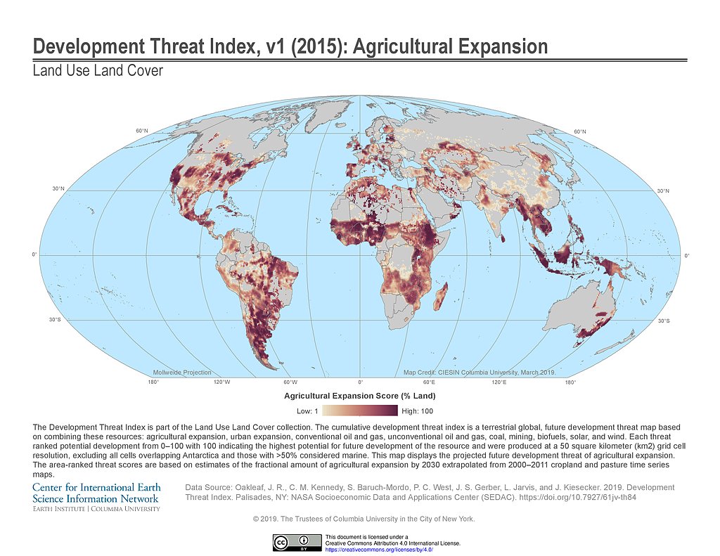
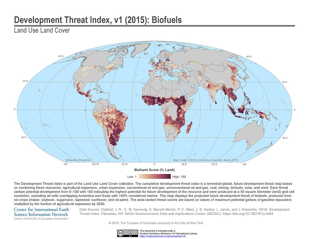
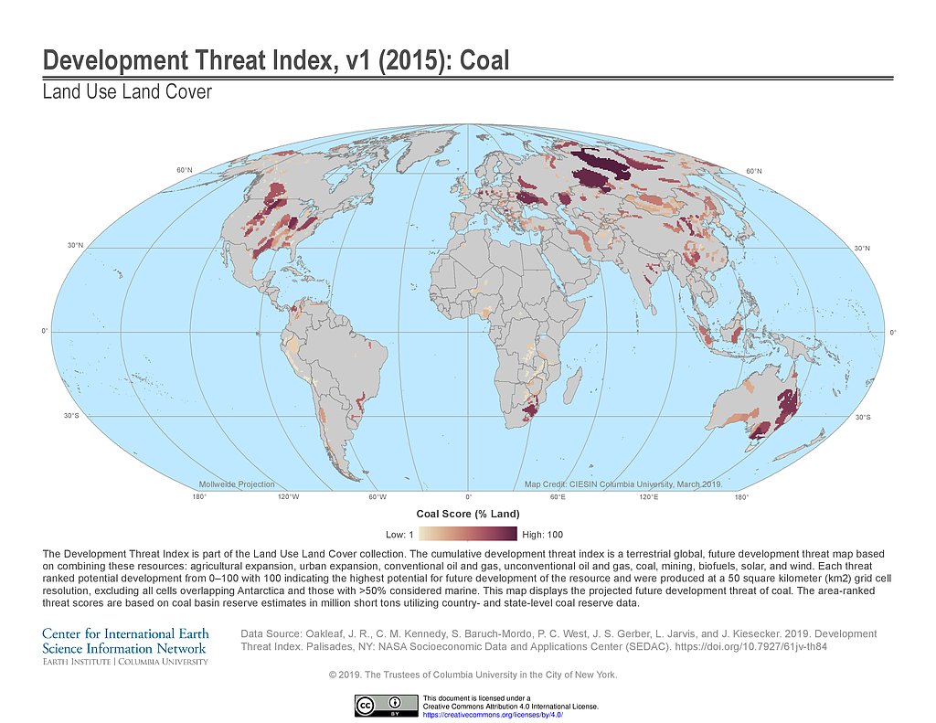
Land Use and Land Cover (LULC)

Follow Us: Twitter Follow Us on Facebook YouTube Flickr   |   Share: Twitter Facebook
  • Collection Overview
  • Data Sets (6)
  • Map Gallery (29)
    Search
    Region
    Global (24)
  • Map Services (13)
  • Citations
Data Sets » Theme: PopulationRemove Facet
1 of 1
Prev | Next

Development Threat Index (2015)

Map: Development Threat Index (2015)
Hi-Resolution: PDF | PNG

Development Threat Index (2015): Agricultural Expansion

Map: Development Threat Index (2015): Agricultural Expansion
Hi-Resolution: PDF | PNG

Development Threat Index (2015): Biofuels

Map: Development Threat Index (2015): Biofuels
Hi-Resolution: PDF | PNG

Development Threat Index (2015): Coal

Map: Development Threat Index (2015): Coal
Hi-Resolution: PDF | PNG

Development Threat Index (2015): Conventional Oil and Gas

Map: Development Threat Index (2015): Conventional Oil and Gas
Hi-Resolution: PDF | PNG

Development Threat Index (2015): Mining

Map: Development Threat Index (2015): Mining
Hi-Resolution: PDF | PNG

Development Threat Index (2015): Solar

Map: Development Threat Index (2015): Solar
Hi-Resolution: PDF | PNG

Development Threat Index (2015): Unconventional Oil and Gas

Map: Development Threat Index (2015): Unconventional Oil and Gas
Hi-Resolution: PDF | PNG

Development Threat Index (2015): Urban Expansion

Map: Development Threat Index (2015): Urban Expansion
Hi-Resolution: PDF | PNG

Development Threat Index (2015): Wind

Map: Development Threat Index (2015): Wind
Hi-Resolution: PDF | PNG

Development Potential Indices (2016): Biofuels

Map: Development Potential Indices (2016): Biofuels
Hi-Resolution: PDF | PNG

Development Potential Indices (2016): Coal

Map: Development Potential Indices (2016): Coal
Hi-Resolution: PDF | PNG

Development Potential Indices (2016): Concentrated Solar Power

Map: Development Potential Indices (2016): Concentrated Solar Power
Hi-Resolution: PDF | PNG

Development Potential Indices (2016): Conventional Gas

Map: Development Potential Indices (2016): Conventional Gas
Hi-Resolution: PDF | PNG

Development Potential Indices (2016): Conventional Oil

Map: Development Potential Indices (2016): Conventional Oil
Hi-Resolution: PDF | PNG

Development Potential Indices (2016): Crops

Map: Development Potential Indices (2016): Crops
Hi-Resolution: PDF | PNG

Development Potential Indices (2016): Metallic Mining

Map: Development Potential Indices (2016): Metallic Mining
Hi-Resolution: PDF | PNG

Development Potential Indices (2016): Non-metallic Mining

Map: Development Potential Indices (2016): Non-metallic Mining
Hi-Resolution: PDF | PNG

Development Potential Indices (2016): Photovoltaic Solar Power

Map: Development Potential Indices (2016): Photovoltaic Solar Power
Hi-Resolution: PDF | PNG

Development Potential Indices (2016): Unconventional Gas

Map: Development Potential Indices (2016): Unconventional Gas
Hi-Resolution: PDF | PNG

Development Potential Indices (2016): Unconventional Oil

Map: Development Potential Indices (2016): Unconventional Oil
Hi-Resolution: PDF | PNG

Development Potential Indices (2016): Wind

Map: Development Potential Indices (2016): Wind
Hi-Resolution: PDF | PNG

Probabilities of Urban Expansion (2000-2030)

Map: Probabilities of Urban Expansion (2000-2030)
Hi-Resolution: PDF | PNG

Human Modification of Terrestrial Systems (2016)

Map: Human Modification of Terrestrial Systems (2016)
Hi-Resolution: PDF | PNG
Data Sets » Theme: PopulationRemove Facet
1 of 1
Prev | Next

Home | Data | Data Uses | Data Citations | Maps | Map Services

News | Tools | Guides | Publications | Blog Posts

About | Help | Privacy | User Registration

Copyright © 1997–2023. The Trustees of Columbia University in the City of New York.

WDS ICSU