NASA Website Socioeconomic Data and Applications Center (sedac)
A Data Center in NASA's Earth Observing System Data and Information System (EOSDIS) — Hosted by CIESIN at Columbia University
Data
  • Data Sets
  • Maps
  • Web Pages
  • home
  • Data
    • · Data Sets
    • · Data Collections
    • · Featured Data Uses
    • · Data Citations
    • · Citations Database
    • · Data Submission
  • Maps
    • · Map Gallery
    • · Map Viewer
    • · Map Services
    • · Mapping Tools
  • Themes
    • · Agriculture
    • · Climate
    • · Conservation
    • · Governance
    • · Hazards
    • · Health
    • · Infrastructure
    • · Land Use
    • · Marine and Coastal
    • · Population
    • · Poverty
    • · Remote Sensing
    • · Sustainability
    • · Urban
    • · Water
  • Resources
    • · Guides
    • · Multimedia
    • · Networks
    • · News
    • · Publications
    • · Related Sites
    • · Remote Sensing
    • · Tools
  • Social Media
    • · Twitter
    • · FaceBook
    • · YouTube
    • · Flickr
    • · Blog Posts
    • · Communities
  • About
    • · About SEDAC
    • · User Working Group
    • · Privacy
    • · User Registration
  • Help
 

Natural Disasters

Follow Us: Twitter Follow Us on Facebook YouTube Flickr   |   Share: Twitter Facebook
  • Collection Overview
  • Methods
  • Data Sets (6)
  • Map Gallery (3)

Included in this collection is the Geocoded Disasters (GDIS) Dataset, v1 (1960 – 2018), which is a geocoded extension of a selection of natural disasters from the Centre for Research on the Epidemiology of Disasters' (CRED) Emergency Events Database (EM-DAT). The data set encompasses 39,953 locations for 9,924 disasters that occurred worldwide in the years 1960 to 2018.

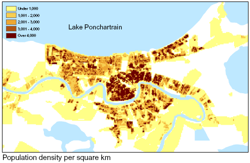
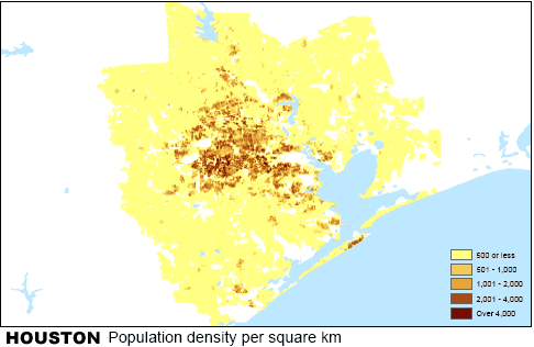
Also in the collection are five gridded population data sets showing the pre-disaster characteristics of the populations that appear to have been most directly affected by Hurricanes Katrina and Rita.

CIESIN used Census 2000 block geography and Summary File 1 attribute data to generate raster surfaces of 24 demographic variables for the states most affected by Katrina and Rita (Alabama, Louisiana, Mississippi, and Texas) at a resolution of 30 arc-seconds. Detailed grids of the same variables are available for the New Orleans and Houston metropolitan statistical areas at a resolution of 7.5 arc-seconds.

In addition, Census 2000 block group geography and Summary File 3 attribute data were used by CIESIN to generate raster surfaces of 16 additional demographic variables for Alabama, Louisiana, and Mississippi at a resolution of 30 arc-seconds. These additional variables include income, poverty status, education, and housing age.  Detailed grids of the same variables are available for the New Orleans metropolitan statistical areas at a resolution of 7.5 arc-seconds.

Home | Data | Data Uses | Data Citations | Maps | Map Services

News | Tools | Guides | Publications | Blog Posts

About | Help | Privacy | User Registration

Copyright © 1997–2023. The Trustees of Columbia University in the City of New York.

WDS ICSU