Global Roads
Global Roads Open Access Data Set (gROADS), v1 (1980 – 2010 )
Downloads
- Data:
- View Recommended Citation(s)
X
- Recommended Citation(s)*:
-
Center for International Earth Science Information Network - CIESIN - Columbia University, and Information Technology Outreach Services - ITOS - University of Georgia. 2013. Global Roads Open Access Data Set, Version 1 (gROADSv1). Palisades, New York: NASA Socioeconomic Data and Applications Center (SEDAC). https://doi.org/10.7927/H4VD6WCT. Accessed DAY MONTH YEAR.
 ENW (EndNote & RefWorks)†
RIS (Others)
* When authors make use of data they should cite both the data set and the scientific publication, if available. Such a practice gives credit to data set producers and advances principles of transparency and reproducibility. Please visit the data citations page for details. Users who would like to choose to format the citation(s) for this dataset using a myriad of alternate styles can copy the DOI number and paste it into Crosscite's website.
† For EndNote users, please check the Research Note field for issues with importing authors that are organizations when using the ENW file format.
The global and regional data are available as zip files in Esri Geodatabases (.gdb) format. The shapefiles (.shp) are for the regional data only. Downloaded files need to be uncompressed in a single folder using either WinZip (Windows file compression utility) or similar application before they can be accessed by your GIS software package. Users should expect an increase in the size of downloaded data after decompression.
The data are stored in geographic coordinates of decimal degrees based on the World Geodetic System spheroid of 1984 (WGS84). Users should consult the gROADSv1 documentation for complete information on the data set.
Extents of Regional Data Downloads:
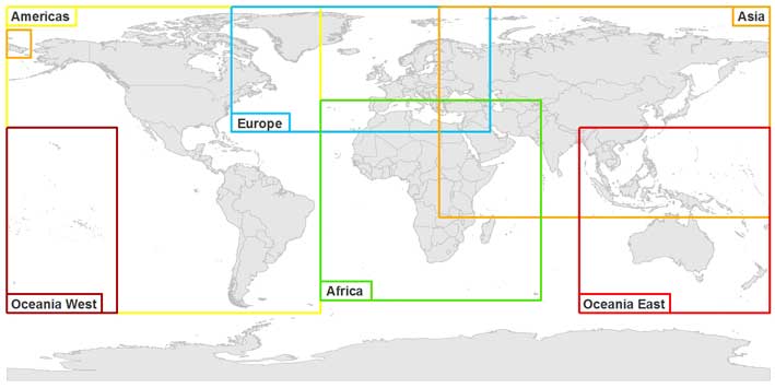
| Global | Geodatabase [196 MB] | |
| Africa | Geodatabase [91.9 MB] | Shapefile [206 MB] |
| Asia | Geodatabase [86.7 MB] | Shapefile [194 MB] |
| Europe | Geodatabase [53.9 MB] | Shapefile [81.9 MB] |
| Americas | Geodatabase [8.1 MB] | Shapefile [62 MB] |
| Oceania East | Geodatabase [9.5 MB] | Shapefile [13.6 MB] |
| Oceania West | Geodatabase [425 KB] | Shapefile [420 KB] |