Data Sets (5)
|
1 of 1
Prev
|
Next
|
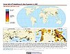
Global Urban Heat Island (UHI) Data Set, v1 (2013)Satellite-Derived Environmental Indicators
To provide a global data set of average summer daytime maximum/nighttime minimum land surface temperatures (LSTs) for urban extents, as well as the LST difference between the urban area and the buffer. |
||
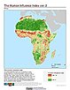
Global Human Influence Index (Geographic), v2 (
|
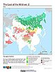
Last of the Wild (Geographic), v2 (
|
|
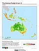
Global Human Footprint (Geographic), v2 (
|
|
1 of 1
Prev
|
Next
|