CIESIN associate director for Science Applications Alex de Sherbinin teamed up with Prof. Andrew Tatem of the University of Southampton in the virtual event, “Using Big Data to Study Migration Patterns,” organized by the Columbia Population Research Center (CPRC) and Columbia’s Data Science Institute (DSI) on April 22. The two researchers discussed the use of novel data streams such as cellphone and device location data to understand mobility patterns. Following the presentation, which drew more than 50 participants, a reception was held for CPRC and DSI affiliates to discuss research collaboration opportunities. Among other activities, de Sherbinin is co-lead of the Climate Mobility Network, a new “Earth Network” established by the Earth Institute. Tatem is the director of WorldPop and a director of Flowminder, and a key collaborator in the GeoReferenced Infrastructure and Demographic Data for Development (GRID3) program managed by CIESIN.
Resources »  News
News
| 2 of 36 |
New Air Quality and Gridded Scenario Data Released
April 9, 2021CIESIN through its NASA Socioeconomic Data and Applications Center (SEDAC) has released two new data sets, one characterizing historical air quality over the period 1998–2016, and the second projecting urban land extent into the future through 2100 under different shared Socioeconomic Pathways (SSPs). The first data set, “Annual PM2.5 Concentrations for Countries and Urban Areas, 1998–2016,” provides annual mean estimates of levels of particulate matter (particles with diameters of 2.5 microns or less) in the atmosphere, derived from observations from satellite-based sensors, for countries and urban areas. The national averages are population-weighted. This data set is based on a gridded data set developed by van Donkelaar et al., also available from SEDAC.
The data set “Global One-Eighth Degree Urban Land Extent Projection and Base Year Grids by SSP Scenarios, 2000–2100” was developed by Jing Gao of the University of Delaware and Brian O’Neill, now director of the Joint Global Change Research Institute at the University of Maryland. The data set characterizes global, spatially explicit urban land scenarios consistent with the SSPs, projected from the base year 2000 to the year 2100 at ten-year intervals, with a spatial resolution of one-eighth degree (7.5 arc-minutes). Such projections are key inputs for analyses of land use, energy use, and emissions and assessments of climate change vulnerability, impacts, and adaptation.
Spring Brings Staff Transitions
April 9, 2021CIESIN is pleased to welcome Lixiang (Tracy) Wen as a finance manager, supporting the GeoReferenced Infrastructure and Demographic Data for Development (GRID3) program, the NASA Socioeconomic Data and Applications Center (SEDAC), and other projects. Tracy comes to CIESIN from the Columbia University Medical Center, where she worked as a financial analyst since 2016. She holds a bachelor of business administration in accounting from Baruch College.
CIESIN bids farewell to Anne-Laure White, research staff assistant, who has begun working at a sustainable farm in the Hudson Valley. A graduate of Columbia University in American Studies, White had diverse roles in the Geospatial Applications Division over the past three years, including co-authoring a recent report on coastal adaptation.
Training in the Basics of Gridded Data and Applications for Addressing SDGs and Disaster Management
April 7, 2021
|
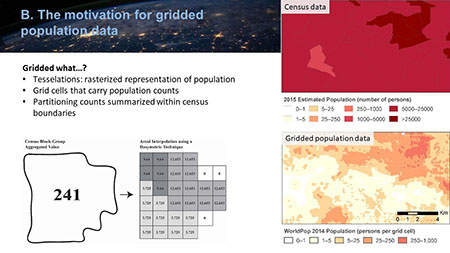
NASA’s Applied Remote Sensing Training Program (ARSET) offered a two-part training course, “Introduction to Population Grids and their Integration with Remote Sensing Data for Sustainable Development and Disaster Management,” on March 30 and April 6. The course was organized by CIESIN research scientist Susana Adamo on behalf of NASA’s Socioeconomic Data and Applications Center (SEDAC) and the POPGRID Data Collaborative, an international network of data providers, users, and sponsors concerned with georeferenced data on population, human settlements, and infrastructure. In the first session of the course, Prof. Steven Leyk of the University of Colorado and CIESIN associate director for Geospatial Applications Greg Yetman provided an overview of gridding population data, from its origins to present day applications in such areas as health, humanitarian response, sustainable development, and environmental management. The second session, organized around case studies of specific applications, featured lectures by CIESIN director Robert Chen, senior geographic information specialist Linda Pistolesi, and Charles Huyck, executive vice president of ImageCat Inc. More than 1,000 people from around the world participated in the course. Each session was given twice during the day, with live question-and-answer periods. Recordings of the sessions are available online via the ARSET web site.
Peter Fox,“Titan” in the Earth Science Informatics Community, Passes Away
April 2, 2021
|
CIESIN joins the broad earth science and informatics communities in mourning the sudden passing of Peter Fox, who was widely respected as a key scholar, thinker, and mentor across a wide range of interrelated fields. At Rensselaer Polytechnic Institute (RPI), Fox was Tetherless World Constellation Chair and director, Information Technology and Web Science Program, as well as professor of earth and environmental sciences, computer science, and cognitive science. He was a past president of the Federation of Earth Science Information Partners (ESIP), which, together with the American Geophysical Union (AGU), the Research Data Alliance (RDA), the Committee on Data (CODATA), and other organizations, characterized Fox as a “titan” in the Earth Science informatics community.
Fox interacted regularly with many CIESIN staff members in different organizations, including ESIP, AGU, RDA, CODATA, and the International Science Council (ISC) World Data System (WDS). CIESIN director Robert Chen served with him on the ISC Strategic Coordinating Committee on Information and Data from 2009 to 2011, which helped guide the modernization and reorganization of the WDS. Fox was an active and valued member of the User Working Group (UWG) of the NASA Socioeconomic Data and Applications Center (SEDAC) operated by CIESIN, serving a four-year term from 2009 to 2013. He was a leading proponent of the value of interdisciplinary scientific data stewardship to advance science and societal benefits. Fox was especially known as a strong and supportive mentor for many different scholars and practitioners across a wide range of fields.
Fox′s colleagues and friends at CIESIN, together with former and current members of the SEDAC UWG, are deeply saddened by this untimely loss and will greatly miss his wisdom, warmth, and wit. We extend our condolences to his family, friends, and colleagues around the world.
Citizen Science Data Quality and Food Security Nexus are Topics of Recent Publications
March 30, 2021A new article in Frontiers in Climate, “Perspectives on Citizen Science Data Quality,” offers a data lifecycle approach for improving data quality. Senior digital archivist Robert Downs is lead author, with co-authors Hampapuram Ramapriyan, Science Systems and Applications, Inc. (SSAI); Ge Peng, University of Alabama Huntsville; and Yaxing Wei, of the ORNL DAAC.
CIESIN research scientist Susana Adamo and associate director for Science Applications Alex de de Sherbinin are among co-authors of the article, “Food Security among Dryland Pastoralists and Agropastoralists: The Climate, Land-use Change, and Population Dynamics Nexus,” appearing in The Anthropocene Review. Lead author is Illan Stavi, Ben-Gurion University of the Negev, Israel. Adamo is also one of the guest editors of the Special Issue of the Inter-American Institute for Global Change Research (IAI), “Bridging Science and Policy through Collaborative, Interdisciplinary Global Change Research in the Americas,” in the journal Environmental Development.
Webinars Highlight Urban Population Data Applications and Data Management Topics
March 26, 2021On March 25, CIESIN senior systems analyst/GIS developer Kytt MacManus moderated a Webinar organized by the Global Forum for Geography and Statistics (GFGS), the United Nations Economic Commission for Europe (UNECE), and the European Free Trade Association (EFTA), on the topics of defining urban areas and modelling urban area data. The first presentation was given by Lewis Dijkstra of the European Commission (EC) and former CIESIN research scientist Deborah Balk of Baruch College, and the second by Thomas Kemper and Marcello Schiavina of the EC Joint Research Centre. MacManus is a member of the GFGS steering committee.
The fourth Webinar in a series designed for a non-technical audience has been produced by the Geo-Referenced Infrastructure and Demographic Data for Development (GRID3) managed by CIESIN. The Webinar, “Principles and Applications of Geographic Information Systems (GIS),” focuses on how GRID3 uses GIS tools and principles to inform its work, with an example from GRID3 activities with Ghana using GIS tools to support census modernization efforts there. Presenters include former CIESIN senior research staff assistant Anela Layugan; Frankline Echerue, technical specialist at the United Nations Population Fund (UNFPA); and Alina Game, GIS analyst at the Flowminder Foundation.
Associate director for Science Applications Alex de Sherbinin gave welcoming remarks February 24 at session one of the Second Latin America and the Caribbean (LAC) Scientific Data Management Workshop. He then presented on the World Data System (WDS) of the International Science Council, for which he chairs the Scientific Committee. WDS convened the workshop in collaboration with the Brazilian Academy of Sciences, the São Paulo Research Foundation (FAPESP), and the Research Data Alliance (RDA).
On February 19, senior digital archivist Robert Downs co-authored the lightning talk, “Toward Improving Representation of Data Quality Information,” which was presented by David Moroni of the NASA Jet Propulsion Lab (JPL) during the Earth Science Information Partners (ESIP) Winter Meeting Highlights Webinar.
New Data Released on Geocoded Hazards, Infant Mortality, and Shared Socioeconomic Pathways
March 22, 2021The NASA Socioeconomic Data and Applications Center (SEDAC) operated by CIESIN has released several new data sets related to hazards, infant mortality, and future socioeconomic scenarios. The Geocoded Disasters (GDIS) Dataset is a geocoded extension of a selection of natural disasters from the Centre for Research on the Epidemiology of Disaster (CRED) Emergency Events Database (EM-DAT). The data set includes nearly 40,000 locations for almost 10,000 disasters worldwide for the 58-year period spanning 1960–2018. It encompasses all EM-DAT-recorded floods, storms, earthquakes, landslides, droughts, volcanic activity and extreme temperatures, some at administrative level 3 (district/commune/village) but most at 1 (typically state/province/region). GDIS facilitates geospatial analysis of past hazard events.
The Shared Socioeconomic Pathways (SSPs) Literature Database consists of biographic information, abstracts, and analysis of 1,360 articles published 2014–2019 that make substantial use of the SSPs. The database was developed by Carole Green et al. as the basis for a recent article in Nature Climate Change that analyzes use of the Climate Change Scenario Framework and associated scenario data sets in diverse application areas and in assessments of the Intergovernmental Panel on Climate Change (IPCC). The International Committee on New Integrated Climate Change Assessment Scenarios (ICONICS) is planning to extend the literature database. SEDAC User Working Group member Brian O'Neill of the Joint Climate Change Research Institute and CIESIN director Robert Chen are members of ICONICS.
Global Subnational Infant Mortality Rates (IMR), Version 2.01, provides more recent and higher-resolution infant mortality data, including estimates of births and infant deaths. The estimates are for 234 countries and territories, 143 of which include subnational units and are benchmarked to the year 2015 (versus year 2000 for the first version). IMR data are drawn from national offices, Demographic and Health Surveys (DHS), Multiple Indicator Cluster Surveys (MICS), and other sources covering 2006–2014. The birth and infant death data can be aggregated or disaggregated to calculate IMRs at different scales or resolutions. Boundary inputs are derived primarily from the Gridded Population of the World, Version 4 (GPWv4) data collection. National and subnational data are mapped at a spatial resolution of 30 arc-seconds (~1 km at the equator), facilitating integration with demographic, environmental, and other spatial data. Data set development was led by senior geographic information specialist Dara Mendeloff and research scientist Susana Adamo.
The data set, Georeferenced U.S. County-Level Population Projections, Total and by Sex, Race and Age, Based on the SSPs, 2020–2100, contains county-level population projection scenarios of total population, and by age, sex, and race in five-year intervals for all US counties 2020–2100. These data can serve as inputs for addressing questions involving sub-national demographic change in the United States in the near, middle- and long-term.
Population Data Discussed at United Nations Statistical Commission Side Events
February 26, 2021Two side events held in preparation for the United Nations Statistical Commission 52nd Session included discussion of the use of georeferenced population data in supporting efforts to meet the Sustainable Development Goals (SDGs) at global, national, and subnational levels. On February 16, CIESIN director Robert Chen served as a panelist in the virtual event, “Working to Improve Timeliness and Granularity of SDG data: Progress Made in the Data for Now Initiative.” Organized by the Global Partnership for Sustainable Development Data (GPSDD) and the UN Sustainable Development Solutions Network (SDSN), the side event drew more than 190 participants from around the world. Chen highlighted progress made by the POPGRID Data Collaborative to improve access to timely, internationally comparable data on human population, settlements, and infrastructure by National Statistical Offices (NSOs) and other users.
On February 25, Prof. Forrest Stevens of the University of Louisville participated in the side event, “The SDGs Geospatial Roadmap,″ organized by the UN Working Group on Geospatial Information (WGGI). The event included a panel on the launch of the Earth Observation Toolkit for Sustainable Cities, organized by UN-Habitat and the Earth Observations for the Sustainable Development Goals (EO4SDG) initiative of the Group on Earth Observations (GEO). Stevens discussed contributions of the GEO Human Planet Initiative (HPI) to the new toolkit, which features a range of data, tools, and services developed by several HPI participants, such as the Joint Research Centre of the European Commission and a NASA-funded project led by CIESIN in collaboration with the University of Louisville and ImageCat, Inc.
Established in 1947, the United Nations Statistical Commission is the highest body of the global statistical system, bringing together the chief statisticians from member states from around the world. Its 52nd Session was held virtually March 1–5.
SEDAC User Working Group Welcomes Five New Members
February 9, 2021Five experts from academia, government, and the private sector have joined the User Working Group (UWG) of the NASA Socioeconomic Data and Applications Center (SEDAC) for four-year terms. The new members are Nita Bharti, assistant professor of biology at the Center for Infectious Disease Dynamics of Penn State University; Mariel Borowitz, associate professor in the Sam Nunn School of International Affairs at the Georgia Institute of Technology; Lola Fatoyinbo, research physical scientist in the Biospheric Sciences Lab at NASA Goddard Space Flight Center (GSFC); Charlie Frye, chief cartographer at Esri; and David Van Riper, director of spatial analysis for the Minnesota Population Center at the University of Minnesota. The UWG is chaired by Barbara Ryan, former executive director of the Group on Earth Observations who is now serving as executive director of the World Geospatial Industry Council. Ryan chaired a virtual briefing for the new members February 5, with participation by Nancy Searby, SEDAC program scientist from NASA Applied Sciences, and Francis Lindsay, SEDAC Distributed Active Archive Center (DAAC) engineer from NASA GSFC. Updates on SEDAC activities and plans were provided by SEDAC manager Robert Chen, deputy manager Alex de Sherbinin, and project scientist Susana Adamo. The UWG provides guidance to SEDAC and NASA on user needs and priorities related to the human dimensions data, and associated tools and services, developed and managed by SEDAC, one of 12 DAACs in NASA′s Earth Observing System Data and Information System (EOSDIS).
Guggenheim Exhibit Highlights Human Transformation of the Countryside
February 5, 2021
|
“Countryside, The Future,” an exhibit at the Solomon R. Guggenheim Museum for innovative art and architecture in New York City, features a prominent wall-size display of interactive maps that visualize how humans have transformed the countryside−the surface of Earth not occupied by urban growth. Many of the maps are based on data from the NASA Socioeconomic Data and Applications Center (SEDAC) operated by CIESIN, as well as other remote-sensing data sets from NASA and other sources. The installation was created by urban architect Rem Koolhaas and Samir Bantal, director of AMO, the think tank of the Office for Metropolitan Architecture (OMA). Also contributing were students from the Harvard Graduate School of Design; the Central Academy of Fine Arts, Beijing; Wageningen University, Netherlands; and the University of Nairobi. The exhibit originally opened in February 2020 for three weeks, but closed due to the pandemic along with the Museum, until its reopening in October 2020. The exhibit has been extended through February 15, 2021.
Virtual Winter Meeting Tackles Innovation in Earth Science Data Frontiers
February 1, 2021The 2021 winter meeting of the Earth Science Information Partners (ESIP), held online January 26–29, addressed the theme, “leading innovation in earth science data frontiers.″ CIESIN senior digital archivist Robert Downs co-chaired the January 28 session, “Toward Improving Representation of Data Quality Information,” and gave the presentation, “International Collaboration on Data Quality” during the session. During the Research Showcase on January 27, he presented the poster, “Adopting the TRUST Principles for Digital Repositories with the GEOSS Data Management Principles and the GEOSS Data Sharing Principles.” Downs also presented the ESIP Martha Maiden Lifetime Achievement Award for Service to the Earth Science Information Community to Hampapuram Ramapriyan, research scientist at Science Systems and Applications, Inc., who has made significant contributions to data management and stewardship at NASA and in national and international networks over multiple decades. Robert Chen, CIESIN director and manager of the NASA Socioeconomic Data and Applications Center (SEDAC), also participated in the meeting, which included diverse sessions on such topics as managing model-related data, air quality data user needs, development of analysis-ready data, implementation of Google′s data search tool, and use of data during response to California wild fires. SEDAC has been a Type 1 ESIP partner since 1999.
New Pubs From CIESIN
January 26, 2021New publications from CIESIN include an article authored by senior digital archivist Robert Downs and the latest newsletter in a series by the Geo-referenced Infrastructure and Demographic Data for Development (GRID3) program. The paper by Downs, ″Improving Opportunities for New Value of Open Data: Assessing and Certifying Research Data Repositories,″ was published in the Data Science Journal. It describes how meeting data repository certification standards, such as CoreTrustSeal, contributes to new value that can be attained for society through the use of open data products and services. The GRID3 newsletter features progress in the organization's partnership with Nigeria, including management of the data and portal and population data modelling to support the COVID-19 response there; use of GRID3 data to help the government of Liberia save more than one million dollars in its recent purchase of high-resolution satellite imagery; and in-country training to increase geospatial capacity in African countries.
2020 Human Planet Atlas Showcases Diverse Applications of Global Human Settlement and Population Data
January 22, 2021The Joint Research Centre (JRC) of the European Commission has released the 2020 edition of the Atlas of the Human Planet, focused on open geoinformation for research, policy, and action, under the auspices of the Human Planet Initiative of the Group on Earth Observations (GEO). This year′s Atlas features more than 30 applications of the georeferenced human settlement and population data in four thematic areas: disaster risk management, urbanization, development, and environment and sustainability. Two of the applications showcased were developed by CIESIN: the Global COVID-19 Viewer operated by the NASA Socioeconomic Data and Applications Center (SEDAC), in “Mapping the COVID-19 Pandemic and Potential Risk Factors,″ and a summary of an update to a 2007 data set available from SEDAC, in “New Estimates of Global Population and Land in the Low Elevation Coastal Zone Using GHSL-based Data Sets.″ The first showcase was prepared by CIESIN director Robert Chen, GIS programmer Kytt MacManus, and associate director for Science Applications Alex de Sherbinin. The second was authored by MacManus, former SEDAC project scientist Deborah Balk of Baruch College, staff associate Hasim Engin, UK demographer Gordon McGranahan, former research staff assistant Rya Inman, and intern Alexandra Hayes.
The JRC organized a virtual launch event January 21 that drew more than 90 participants. The event included 4 short presentations on selected applications, including the Global COVID-19 Viewer example, described by Chen. The Viewer, developed and enhanced in 2020, helps users visualize a range of data on COVID-19 cases and mortality in relationship to spatial data on demographic and environmental factors that may affect exposure and vulnerability, such as age structure, degree of urbanization, air quality, and elevation. Chen and Martino Pesaresi of the JRC are co-leaders of the GEO Human Planet Initiative.
International Forum and Online Educational Video Provide Opportunities for CIESIN Participation
January 20, 2021CIESIN senior geographic information specialist Dara Mendeloff was an invited rapporteur for select sessions of the OGC Location Powers Urban Digital Twins virtual summit held January 12–14. The focus of the conference was how “digital twins” at the urban scale use location and geospatial technology to transform how cities are planned, built, and managed to better deliver services in order to create more livable, inclusive, safe, resilient and sustainable urban environments. Mendeloff represented both OGC members CIESIN and the NYC Geographic Information System and Mapping Organization (GISMO), where she is a member of the Board of Directors. In consideration of the international audience of the virtual summit, the OGC aimed to make presentations available in both east and west time zones and to build on each other, so she also presented her summary report of the 1W session to sessions 1E and 2W. Her report will be included in a final document that summarizes discussion on the status of Digital Twins and recommends future technology innovations, best practices, and standards development. The OGC is the Open Geospatial Consortium, an international organization committed to improving access to geospatial and location information, including the development of free, publicly available geospatial standards that enable new technologies.
On January 21, Mendeloff reprised her role as an instructor for the Earth Institute (EI) Live K–12 science education video series, when she offered a session aimed at grades 9–12, “Climate Data—The Numbers Behind the Numbers.” The 45-minute video, available on the EI Live channel, explains the data science tools used in climate research by scientists to understand geographic data, perform spatial analysis, and visualize data while communicating a story.
Climate and Migration, Managed Retreat, and Data Best Practices Discussed by CIESIN Scientists
December 21, 2020Associate director for Science Applications Alex de Sherbinin gave a talk December 18 on the intersection of climate change impacts and migration to the Uncommon Schools, a network of charter schools serving minority students in New York City. Earlier in the month, he also served on a panel, “In Crowding Climate Danger Zones, Seeking Paths to Managed Retreat,” held December 16 as part of the Sustain What? Webcast series. The panel, moderated by journalist Andrew Revkin, founding director of the Earth Institute's Initiative on Communication and Sustainability, also included colleagues Lisa Dale and Radley Horton, who with de Sherbinin are on the organizing committee for an upcoming 2021 conference on managed retreat.
Senior digital archivist Robert Downs recently posted a blog entry for the World Data System (WDS) of the International Science Council (ISC) on data citation practices. The December 15 post summarizes an opinion piece published November 16 in EOS, with lead author Suresh Vannan and co-authors Walt Meier, Bruce Wilson, and Irina Gerasimov. The article argues that concerted efforts by the research community are needed to expand appropriate citation of data sets, in order to improve the provenance and reproducibility of research and thereby its credibility and value.
In another WDS blog post, released December 4, de Sherbinin discusses current data practices in citizen science, based on an article co-authored with lead author Anne Bowser of the Wilson Center that was recently published in the journal Citizen Science: Theory and Practice. Improving data management practices in citizen science is critical to ensuring that these efforts produce useful data for scientific research or policy applications. The article was an output of a joint Task Group on the Validation, Curation, and Management of Citizen Science and Crowdsourced Data established by the ISC Committee on Data (CODATA) and the WDS, which de Sherbinin co-chaired. He is also the current chair of the WDS Scientific Committee and a co-chair of a new CODATA-WDS Task Group, “Citizen Science for the SDGs.”
Global Earth Science Community Connects Online for Annual Meeting
December 18, 2020An online version of the annual American Geophysical Union (AGU) Fall Meeting brought together nearly 29,000 scientists and other experts for more than two weeks of online presentations, sessions, and exhibits December 1–17. CIESIN experts organized or co-chaired seven sessions and presented or co-authored twelve invited, oral, e-lightning, and poster papers, on a range of topics in multiple AGU tracks, including Global Change, Natural Hazards, Earth and Space Science Informatics, and Science and Society. Oral sessions included pre-recorded video talks of up to 15 minutes, combined with a one-hour live session with five-minute summaries and a moderated discussion. E-lightning sessions combined an online, interactive “iposter” with a one-hour live session with three-minute summaries and a discussion period. Posters consisted of an iposter made available for 24 hours within a designated visit period. This unique format enabled participation by scientists all over the world, albeit often at unusual hours of the day or night depending on time zones.
Alex de Sherbinin, associate director for Science Applications, presented an e-lightning paper on the Global COVID-19 Viewer, a mapping tool for data related to the coronovirus pandemic developed by the NASA Socioeconomic Data and Applications Center (SEDAC). Senior digital archivist Robert Downs gave two different e-lightning talks: “A Data Lifecycle Approach to Enabling Use by Capturing Data Provenance and Attribution” and “Advancing Open Data Sharing Across the Earth, Social, and Health Sciences for Pressing Societal Challenges.” CIESIN director Robert Chen presented the e-lightning paper, “Why People Matter: Better Data on Population and Infrastructure to Assess SDG Progress.”
Cascade Tuholske, an Earth Institute Postdoctoral Fellow hosted by CIESIN, gave an oral paper, “Global Urban Population Exposure to Extreme Heat,” and an e-lightning presentation, “A Comparison of Gridded Population Data Products in Disaster Response.” Another CIESIN postdoctoral research scientist, Carolynne Hultquist, gave an oral presentation, “Developing Flood Risk Maps for Multi-Level Humanitarian Decision Making.”
Many CIESIN staff members were also co-authors on numerous papers given by colleagues from the Earth Institute or external partners such as the Earth Science Information Partners (ESIP), the German Climate Computing Centre (DKRZ), ImageCat Inc., ISciences LLC, and the United Nations Sustainable Development Solutions Network (SDSN). Chen, de Sherbinin, and Downs also convened and/or co-chaired multiple sessions on topics such as environmental intelligence, remote sensing applications in disaster management, trustworthy digital repositories, and open data sharing. Although the AGU′s online format limited the extent of informal networking and scientific discussion normally possible with an in-person conference, it did seem to allow wider participation from those who might otherwise not be able to attend, and generated a valuable set of prerecorded presentations and online posters that can be made available to a wider audience.
Virtual Conferences Expand Opportunities for International Discussion and Outreach
December 8, 2020Due to the ongoing pandemic, many international conferences have shifted to online, virtual platforms in 2020, opening up opportunities for CIESIN staff to interact remotely with new communities and showcase recent work and new resources. For example, associate director for Science Applications Alex de Sherbinin recently gave a remote keynote address, “Groundswell Model Results for South Asia,” November 25 at the International Conference on Building Resilient and Sustainable Societies, organized by Jamia Millia Islamia University in New Delhi. The address discussed ongoing work with the World Bank to model how climate impacts may induce migration out to 2050. He and research scientist Susana Adamo also participated in the virtual meeting of the Platform for Disaster Displacement’s Data and Knowledge Working Group November 24, where they gave the respective presentations, “Novel and Big Data Approaches to Identifying Disaster Displacement,” and “Migration, the COVID-19 Pandemic, and Climate in Central America’s Northern Triangle.”
During the International CODATA FAIR Convergence Symposium 2020 held virtually November 27–December 4, CIESIN director Robert Chen presented in a panel session, “Synergies between Citizen Science Data and the UN Sustainable Development Goal (SDG) Indicators,” organized by Dilek Fraisl of the International Institute for Applied Systems Analysis (IIASA) in Austria. Chen then led a breakout group within this session. Alex de Sherbinin also contributed to the session, “Citizen Science in Africa for the SDGs,” giving closing remarks. The Symposium was organized by the Committee on Data (CODATA) of the International Science Council and the GO FAIR initiative.
On December 1 Chen gave a short presentation, “Open Data Sharing Across the Disaster Lifecycle," in the community session, "A Call to Action for Resilience: Moving from Research to Practice,” held as part of the World Bank’s 2020 Understanding Risk Forum (UR2020) December 1–3. The session was organized by Charles Huyck of ImageCat, Inc. and Shanna McClain of NASA. Chen highlighted the importance of open data access and reuse throughout the disaster management lifecycle, not just in the immediate aftermath of an extreme event.
Experts from Colombia and Paraguay Participate in Workshop on Using Gridded Population Data for Sustainable Development
December 2, 2020Professor Stefan Leyk of the University of Colorado organized and led a virtual workshop November 30, “Gridded Population Data for the Sustainable Development Goals,” for experts from Colombia's National Administrative Department of Statistics (DANE) and Paraguay's General Directorate of Statistics, Surveys, and Censuses (DGEEC). The workshop provided an overview of the development and sources of gridded population data, hands-on technical training in working with selected data, and a forum for obtaining feedback on user needs. CIESIN Director Robert Chen gave introductory remarks during the opening session, and in the final session research scientist Susana Adamo provided an update in Spanish on progress and plans for the fifth version of the Gridded Population of the World (GPW) data set. Associate director for Science Applications Alex de Sherbinin, associate director for Geospatial Applications Greg Yetman, and research staff assistant Juan Martinez also attended.
The workshop was organized by Leyk and Maryam Rabiee of the Thematic Research Network on Data and Statistics (TReNDS) of the United Nations Sustainable Development Solutions Network (SDSN), under the auspices of the POPGRID Data Collaborative. Funding for the workshop was provided by Deutsche Gesellschaft für Internationale Zusammenarbeit (GIZ) GmbH. POPGRID is an initiative launched by CIESIN in 2017 to bring together both developers and users of global georeferenced population data in support of development applications. POPGRID activities and resources are supported in part by the Bill & Melinda Gates Foundation and the NASA Socioeconomic Data and Applications Center (SEDAC). Leyk is also a member of SEDAC′s User Working Group.
CIESIN Highlights the Power of Geographic Information Systems on GIS Day
November 19, 2020CIESIN experts helped to celebrate GIS Day as part of several events held virtually on November 18. For a “Lunch and Learn” Webinar organized by NASA and Esri, Greg Yetman, associate director for Geospatial Applications, gave a 10-minute talk on how geographic information systems (GIS) facilitates the integration of socioeconomic and biophysical data to support interdisciplinary research and applications. He noted CIESIN’s long history in developing gridded population data products, extending back more than 25 years when GIS software was still in its infancy.
Later in the day, CIESIN and the New York City (NYC) Geospatial Information System and Mapping Organization (GISMO) held the online event, “Discover the World Through GIS in NYC.” The event featured presentations by students and researchers from CIESIN and Columbia University, Lehman College of the City University of New York, and the New York City Housing Authority (NYCHA). Nearly 80 people from around the world learned about efforts to map the movement of refugees and COVID-19; plan for disaster housing; evaluate bike paths in the Bronx; implement interactive mapping in the NYCHA; and prioritize tiger habitats in India’s wildlife corridors. The event was hosted by senior geographic information specialist Dara Mendeloff, in coordination with senior geographic information specialist Tricia Chai-Onn. Mendeloff is a member of the Board of Directors of GISMO, a volunteer organization founded in 1990.
| 2 of 36 |