As part of an end-of-project debrief for the African and Latin American Resilience to Climate Change (ARCC) project held October 30 at the headquarters of the U.S. Agency for International Development (USAID) in Washington DC, CIESIN senior research associate Alex de Sherbinin presented the Mali Climate Change Vulnerability Mapping exercise. The event, “Climate Change Impacts on Agriculture and Food Security: Implications for Developing Climate-Resilient Agriculture Programs,” highlighted lessons learned from vulnerability assessments conducted under the three-year ARCC project led by Tetratech/ARD, on which CIESIN was a subcontractor. Panelists described methods and results on the one hand, and uptake by policy audiences on the other. CIESIN climate scientist Sylwia Trzaska also discussed results of the climate projections and downscaling work conducted for the project.
Resources »  News
News
| 24 of 36 |
Partnership on Hazard Exposure Assessment Extended
October 30, 2014The NASA Applied Sciences Program has granted a three-year award to ImageCat, Inc. in collaboration with CIESIN, to utilize remote sensing data to improve estimates of building exposure to earthquake and related hazards. The project builds on a one-year feasibility study completed in early 2014 that demonstrated the potential value of medium-resolution remote sensing data in estimating building structural characteristics in urban areas that lack sufficient building data for risk assessment. ImageCat, an international risk management innovation company, is working with partners in the insurance industry to develop and test products for eventual commercialization. Ron Eguchi, ImageCat’s president and chief operating officer, is the project's principal investigator. CIESIN director Robert Chen is a co-investigator along with ImageCat executive vice president Charles Huyck and consultant David Tralli.
International Meetings Focus on Human Settlement and Geostatistical Data
October 24, 2014Leading researchers in the areas of urban, human settlement, and population mapping gathered at the First Global Human Settlement Workshop, hosted by the European Commission Joint Research Centre (JRC) in Ispra, Italy, October 20–22. CIESIN programmer Kytt MacManus gave a presentation on a range of relevant population and urban settlement data products developed by the NASA Socioeconomic Data and Applications Center (SEDAC), and reported on progress developing version four of the Gridded Population of the World (GPWv4) data set. Lamont Research professor and SEDAC project scientist Christopher Small also participated in the workshop, giving a keynote talk on the spatio-temporal dynamics of human-modified landscapes, based on integrated analysis of remote sensing and gridded population data. The workshop aimed to foster community and facilitate collaboration between various individuals, agencies, and research institutions working to develop new settlement and population data resources.
MacManus subsequently travelled to Krakow, Poland, to attend the 7th Annual European Forum on Geography and Statistics (EFGS) October 22–24. The forum shared knowledge on integration of statistical and geographic data developed by many European and global groups. For a session on best practices, MacManus highlighted lessons learned in developing gridded population data sets.
Improvements in Gridded Population Data Presented to Applied Geographers
October 19, 2014The use of geographical methods and data in a wide range of applications such as disaster management, economic analysis, water quality assessment, food security, and urban and regional development was a major focus of the 37th Applied Geography Conference in Atlanta, Georgia, October 15–17. CIESIN geographic information specialist Erin Doxsey-Whitfield presented a paper on the fourth version of the Gridded Population of the World (GPWv4) data set, now in development. The paper, which will be published in the journal, Papers in Applied Geography, documents the incorporation of new census data and other enhancements in GPWv4. Developed and disseminated by the NASA Socioeconomic Data and Applications Center (SEDAC) operated by CIESIN, previous versions of GPW have been widely used in both research and applications where understanding the spatial distribution of population is critical.
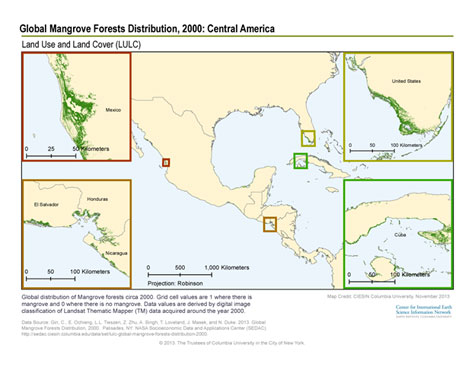
Satellite Data Enable Global Mapping of Mangrove Forests
October 17, 2014
|
The NASA Socioeconomic Data and Applications Center has released a new data set on the extent of mangrove forest cover, which is among the most productive and biologically important ecosystems in the world. Global Mangrove Forests Distribution, version one, indicates that mangrove forests around the year 2000 covered an estimated 137,760 square kilometers across 118 countries and territories worldwide. Mangroves are a unique type of tropical vegetation, appearing as groups of shrubs or trees as high as fifty feet and prospering in the distinct brackish habitats of coastal deltas. Their deep, extensive roots typically host a diversity of small marine organisms that require a hard surface and stable shelter as tides come and go. Mangroves help stabilize shorelines and can reduce the impact of natural hazards such as tsunamis and coastal storms.
The Global Mangrove Forests Distribution data set was derived from one thousand Landsat scenes acquired between 1997 and 2000. Mangrove areas were identified using digital image processing methods and labeled with the help of reference field data and high-resolution commercial satellite imagery. The data are provided at a spatial resolution of about 30 meters, and are organized for downloading as tiles covering 10 degrees latitude by 10 degrees longitude. The data are useful in ecosystem modeling, biodiversity research, land cover change analysis, global carbon accounting studies, coastal hazard assessments, and decision-making regarding human-environment interactions and future adaptive strategies.
The data set was developed by an international team led by Chandra Giri of the U. S. Geological Survey (USGS) Earth Resources Observation Science Center (EROS). Giri has previously worked at CIESIN and recently completed a 3-year term as a member of the SEDAC User Working Group.
Development of the SHared Access Research System Focus of Fall Meeting
October 15, 2014CIESIN senior digital archivist Robert Downs participated in the 2014 fall meeting of the SHared Access Research Ecosystem (SHARE) in Crystal City, Virginia, October 13–14. SHARE is a higher education and research community initiative to ensure the preservation of, access to, and reuse of research outputs, including publications and data. As a member of SHARE’s technical working group, Downs contributed to discussions about the planned SHARE Notification Service, the SHARE Registry, and the interoperability of open access repository networks around the world. SHARE is led by the Association of Research Libraries (ARL), the Association of American Universities (AAU), and the Association of Public and Land-grant Universities (APLU).
Lamont Open House Draws Thousands of Visitors
October 11, 2014
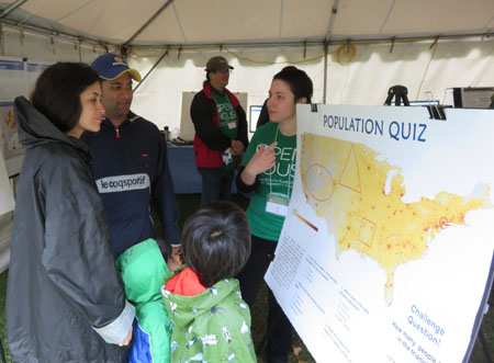
|
|
CIESIN senior research staff assistant Jane Mills helps visitors answer a population quiz, as part of the CIESIN exhibit at the 2014 Lamont Open House of their recent research and development activities. October 11, Palisades, New York. |
Approximately 2,700 students, teachers, and other visitors from the greater New York metropolitan area and beyond braved cold and rainy weather to attend the Lamont-Doherty Earth Observatory Open House 2014 on Saturday, October 11, at the Lamont campus of Columbia University in Palisades, New York. CIESIN’s tent focused on how maps and interactive map tools can be used to address both local and global problems and to educate students about interactions between people and the environment. More than a thousand microfiber cloths displaying a new global map of population distribution, based on the preliminary version four of the Gridded Population of the World data set, were distributed to visitors to commemorate the 25th anniversary of CIESIN’s establishment as a non-profit organization in November 1989. CIESIN relocated to the Lamont campus to become part of the Earth Institute at Columbia University in 1998.
East Africa Workshops Explore Climate Change Adaptation Issues
October 11, 2014CIESIN geographic information specialist Malanding Jaiteh and senior research associate Sandra Baptista participated in back-to-back workshops on climate change vulnerability and adaptation in Bujumbura, Burundi, October 7–10. The workshops were organized by the Planning for Resilience in East Africa through Policy, Adaptation, Research, and Economic Development (PREPARED) program funded by the US Agency for International Development East Africa Mission (USAID/East Africa). The Climate Vulnerability, Impacts, and Adaptation Assessment (VIA) Stakeholders Inception Workshop, held October 7–9, convened experts from the East African Community (EAC) Partner States, representatives from regional institutions, and PREPARED Program partners. The workshop launched the PREPARED VIA process for the Lake Victoria Basin region. Jaiteh gave a presentation on CIESIN’s recent capacity-building training workshops on climate vulnerability mapping conducted in May and August in Nairobi, Kenya. Baptista summarized the results of the PREPARED Climate Information Users and Service Providers Survey. At the Climate Vulnerability Mapping Validation Meeting October 9–10, Jaiteh described the PREPARED climate vulnerability mapping methodology and guided participants in a participatory process to evaluate the preliminary regional climate vulnerability index results and country-level vulnerability maps.
Greg Yetman Rejoins CIESIN as Associate Director for Geospatial Applications
October 6, 2014CIESIN is pleased to announce the appointment of Greg Yetman as associate director for the Geospatial Applications Division, marking his return to CIESIN after three years with Esri Canada. Yetman takes over leadership of CIESIN′s team of geospatial data and information specialists and will play a key role in advancing CIESIN′s geospatial capabilities and infrastructure in support of research and applications.
Yetman originally joined CIESIN in February 1999. He holds a master′s degree in geography from McGill University and a certificate in application and software development from Columbia University.
Water Security Data Featured in Joint Working Group Meeting
October 2, 2014Water as both resource and hazard affecting human security was the theme of a joint meeting of two working groups, the Homeland Infrastructure Foundation-Level Data (HIFLD) Working Group and the World Wide Human Geography Data (WWHGD) Working Group, held September 30–October 1 at the National Geospatial-Intelligence Agency (NGA) campus in Springfield, Virginia. Keynote speakers included Ellen McCarthy, NGA chief operating officer; Monique Yates, director of the NGA Office of Geography; W. Craig Fugate, administrator of the Federal Emergency Management Agency; and Lee Schwartz, geographer of the United States. CIESIN director Robert Chen gave a presentation on October 1 as part of a panel on water for humanitarian assistance and human security, highlighting key water-related data resources and research activities from the NASA Socioeconomic Data and Applications Center (SEDAC) and other CIESIN projects. More than 300 participants from both governmental and nongovernmental organizations attended in person, with additional online participation from around the world.
Established in 2002, the HIFLD working group is a coalition of Federal, state, and local government organizations and supporting private industry partners that recently became a subcommittee of the Federal Geographic Data Committee (FGDC). The WWHGD working group, established in 2011, is building voluntary partnerships around human geography data and mapping in support of human security data needs.
UN Data Revolution Advisory Group Launches Web Site and Consultation
September 29, 2014The United Nations Independent Expert Advisory Group on the Data Revolution for Sustainable Development has launched a new Web site to solicit community inputs for its two-month effort to provide UN Secretary-General Ban Ki-Moon with concrete recommendations on how to bring about a data revolution in sustainable development. The group held its first meeting September 25–26 in New York City, including a session with Deputy Secretary-General Jan Eliassson at the UN Secretariat building September 25 and a “town hall” session at the Microsoft Technology Center in Times Square September 26. The group aims to complete its report by early November. CIESIN director Robert Chen is one of three expert members from U.S.-based institutions and is contributing expertise on geospatial data and technologies, interdisciplinary data integration, and cyberinfrastructure development.
Assessing Societal Vulnerability and Resilience the Subject of Salzburg Workshop
September 18, 2014CIESIN joined with several European organizations to organize and host a scientific workshop, “Spatial Indicators and Assessment of Vulnerability and Resilience,” at the University of Salzburg in Austria September 15–17. CIESIN senior research associate Alex de Sherbinin, a member of the workshop’s extended scientific committee, presented a paper, “Availability and Appropriateness of Data for Vulnerability Mapping,” as well as a poster on vulnerability mapping methods that integrate remote sensing and socioeconomic data. The objective of the workshop was to document current approaches and develop recommendations about good practice for spatial vulnerability assessments to support decision making related to climate change adaptation and disaster risk reduction.
User Needs and Open Geospatial Technologies Featured at Recent Meetings
September 15, 2014CIESIN staff flew to Fairbanks, Alaska, and Portland, Oregon, in early September for meetings concerned with data user needs and open geospatial technologies. In his role as user services manager for the NASA Socioeconomic Data and Applications Center (SEDAC), information specialist Joe Schumacher participated in the NASA EOSDIS User Services Working Group (USWG) meeting at the Alaska Satellite Facility in Fairbanks September 9–11. The USWG coordinates efforts across the NASA earth science data centers to improve support for users. Among the meeting topics was the development of a common metadata repository and new search tools to enhance users’ ability to find data sets across NASA’s large and diverse data holdings. In Portland September 8–13, CIESIN geographic information specialist Dara Mendeloff participated in the FOSS4G (Free and Open Source Software for Geospatial) Conference held by the Open Source Geospatial Foundation (OSGeo). CIESIN utilizes open source geospatial software in many of its online tools and services.
Charles Teller Remembered for Work on Population and Development
September 12, 2014Charles Teller, who had a long and distinguished career in the field of population and development, passed away August 28. Teller was a Population Research Bureau (PRB) Bixby Visiting Fellow, a senior technical advisor in the United States Agency for International Development (USAID) Office of Population and Reproductive Health, director of the Peace Corps in Ethiopia, and visiting professor at the Center for Population Studies at Addis Ababa University in Ethiopia. He served as a steering committee member for the Population and Environment Research Network hosted by CIESIN, and was active in population-environment sessions at meetings of the International Union for the Scientific Study of Population (IUSSP) and the Population Association of America (PAA).
NASA Invites Data Center User Feedback
September 10, 2014Last year,the NASA Earth Observing System Data and Information System (EOSDIS) distributed more than 800 million data products to about 1.7 million users around the world, at an average rate of 22 terabytes of data per day. In order to assess how satisfied users were with the data, tools, and support provided by EOSDIS data centers, NASA commissions an annual user satisfaction survey carried out by the CFI Group. The Socioeconomic Data and Applications Center (SEDAC) operated by CIESIN is one of the centers evaluated through the Web-based survey. Registered SEDAC users should receive an e-mail invitation from CFI Group requesting feedback on the quality and utility of SEDAC data products and services.
User feedback helps SEDAC address user needs and identify ways to improve and enhance the user experience in accessing and using SEDAC’s data, services, and Web site. The anonymous questionnaire takes approximately 20 minutes to complete, with optional comment fields provided. Users who are not currently registered but who would like to complete the survey should contact SEDAC User Services.
UN Advisory Group Formed on Data Revolution for Sustainable Development
September 2, 2014United Nations Secretary-General Ban Ki-moon has established a new UN Independent Expert Advisory Group on the Data Revolution for Sustainable Development to provide him with inputs on “an ambitious and achievable vision” for a future development agenda beyond 2015 to succeed the UN Millennium Development Goals (MDGs). The group of 24 experts from civil society, private sector, academia, governments and international organizations is co-chaired by Prof. Enrico Giovannini of Italy and Robin Li of China. CIESIN director Robert Chen is one of the experts named to the advisory group. The group is expected to assess new opportunities to support and complement conventional statistical systems and strengthen accountability at the global, regional and national levels, and will advise on measures to close data gaps and strengthen national statistical capacities.
New Publications on Environmental Indicators, Migration in North America
August 30, 2014Two new publications by CIESIN scientists examine the use of satellite data in developing policy-relevant environmental indicators and the intersection of migration and environmental trends in North America in the context of global environmental change. CIESIN senior research associate Alex de Sherbinin is lead author of the article, “Using Satellite Data to Develop Environmental Indicators,” co-authored with deputy director Marc Levy and geographic information specialist Malanding Jaiteh. The article in the August 2014 issue of the journal Environmental Research Letters presents the results of a pilot effort to develop satellite-derived indicators in three major issue areas: ambient air pollution, coastal eutrophication, and biomass burning.
A chapter on migration and environmental change in the United States and Canada, written by associate research scientist Susana Adamo and de Sherbinin, appears in the book, People on the Move in a Changing Climate, edited by Etienne Piguet and Frank Laczko. The chapter includes a historical review of past migrations related to environmental events, a description of regional climate change forecasts and current migrations trends, and an overview of recent research on population mobility and climate change events.
New Initiative on Risk and Resilience Discussed at Bellagio Workshop
August 29, 2014CIESIN deputy director Marc Levy participated in a workshop at the Rockefeller Foundation Bellagio Center in Bellagio, Italy, August 26–28 that brought together global change scientists and private sector leaders on the subject of risk and resilience. Discussions concentrated on a new initiative to seek corporate-level disclosure of 1-in-100-year risk. Participants evaluated the potential benefits of the proposed plan and discussed ways to promote its adoption and implementation. The Rockefeller Foundation Bellagio Center′s mission is to promote innovation and identify impact-oriented solutions to critical global problems.
Integrating Novel Water Data and Indicators Examined at UN Team Meeting
August 12, 2014An international task team convened by the United Nations (UN) World Health Organization (WHO), UN HABITAT, and the UN Environment Programme (UNEP) met August 11–12 in College Park, Maryland, to continue discussions on how Earth observations (EO) and other novel data, as well as new data integration approaches, could contribute to the monitoring of future Sustainable Development Goals (SDGs) related to water. The WHO-HABITAT-UNEP task team is one of a number of UN efforts to develop strategies for post-2015 global monitoring of the planned SDGs, which are actively being considered by the international community. CIESIN director Robert Chen gave a presentation on novel water-related data and indicators available from CIESIN, including current progress in preparing version four of the Gridded Population of the World (GPW) data set and in developing transboundary water basin indicators as part of the Transboundary Waters Assessment Programme (TWAP). He also discussed lessons learned by CIESIN over the past decade in developing policy-relevant environmental performance and sustainability indicators. The team meeting was held at the National Oceanic and Atmospheric Administration (NOAA) Center for Weather and Climate Prediction at the University of Maryland.
Staff Trainings Focus on Data Management and Cyberinfrastructure
August 5, 2014Several CIESIN staff participated in training workshops and courses this past month. Digital archivist Yitzhak Gitelman travelled to the University of Michigan in Ann Arbor for a workshop tailored to data professionals, “Curating and Managing Research Data for Re-Use,” July 28–August 1. Offered by the Inter-university Consortium for Political and Social Research (ICPSR) as part of their summer program, the workshop addressed data curation practices throughout the entire research data life cycle. CIESIN programmer James Carcone attended a jQuery training class given by Learning Tree International June 22–25 in New York City. The course covered dynamic Web 2.0 applications using JQuery, HTML, CSS, and Ajax and included hands-on experience in building and testing JQuery components. David Strom, a system administrator at CIESIN, took part in a RedHat Linux training class in Edison, New Jersey, June 21–24. The class reviewed key technologies such as systemd, firewalld, and IPv6 and related management and troubleshooting topics. These training activities were supported by the NASA Socioeconomic Data and Applications Center (SEDAC) to help ensure that SEDAC maintains state-of-the-art, secure data resources and services for its user community.
| 24 of 36 |