CIESIN staff were among more than 20,000 scientists, educators, students, and other experts participating in the fall meeting of the American Geophysical Union (AGU) December 3–7 in San Francisco. In a Union session, “Scientific Observation Network Interoperability in the 21st Century,” CIESIN director Robert Chen gave an invited presentation, "Integrating Data and Networks: Human Factors" and participated in a subsequent panel discussion moderated by Len Hirsch of the Smithsonian Institution. Senior digital archivist Robert Downs presented two posters, one comparing sustainable approaches for long-term data stewardship, co-authored with Chen, and a second on analysis of data citations to assess the scientific and societal value of data from the NASA Socioeconomic Data and Applications Center (SEDAC), co-authored with Chen and senior information specialist Joe Schumacher. Downs also co-convened oral and poster sessions on open source technologies, and gave a poster presentation, “Adopting Open Source Software to Address Software Risks during the Scientific Data Life Cycle,” co-authored with CIESIN associate director of information technology Sri Vinay. Schumacher helped staff the popular NASA exhibit booth, and Downs demonstrated the NASA-funded Climate Health Analysis for Global Education (CHANGE) Viewer mapping tool developed by CIESIN in partnership with IAGT, Inc. The AGU has been increasing its activities in key areas of interest to CIESIN, including Earth and space science informatics and the role of Earth science in public policy and decision making.
Resources »  News
News
| 30 of 36 |
New Findings: Climate Change Will Add to Social Stress, Leading to Security Challenges
November 19, 2012The U.S. National Research Council released a report, “Climate and Social Stress: Implications for Security Analysis,” on November 9. CIESIN Deputy director Marc Levy served as a member of the study committee that produced the report, which was commissioned by the U.S. intelligence community. The committee found that climate change in the coming decade will contribute to significant social and political stress, generating security problems for the U.S. The report points out that current U.S. government capabilities to monitor and evaluate such challenges are not adequate. It recommends a systematic whole-of-government strategy for collecting and analyzing information, and for periodic “stress testing” of critical countries, regions, and systems to better understand climate vulnerabilities.
NASA Data Centers Address Earth Science Data Management Issues in Annapolis
November 16, 2012CIESIN data center services manager John Scialdone and senior digital archivist Robert Downs represented the NASA Socioeconomic Data and Applications Center (SEDAC) at the 2012 Earth Science Data System Working Group (ESDSWG) meeting held November 13–15, 2012 in Annapolis, Maryland. Downs presented two posters, the first, “Data Center Audit for Continuous Quality Improvement,” authored with CIESIN director and SEDAC manager Robert Chen, and a second, “The NASA Earth Science Data Systems Software Reuse Working Group: 2012 in Review,” authored and presented with Chris Mattman, Paul Ramirez, Cameron Goodale, and Andrew Hart of the NASA Jet Propulsion Laboratory. Downs also presented a summary of the Data Quality initiative that was proposed for the ESDSWG during the plenary session on November 15. The ESDSWG develops recommendations and coordinates efforts to improve NASA’s distributed Earth science data systems.
Open Data for a Changing Planet Theme of Taipei Conference
November 1, 2012More than 250 experts on scientific data and information gathered in Taipei for the 23rd International Conference of CODATA, the Committee on Data for Science and Technology of the International Council for Science (ICSU). CIESIN director Robert Chen, in his capacity as CODATA’s secretary-general, had a prominent role in the conference, chairing a session on local to global data challenges, serving as a panelist in a session, “What Do We Mean by Open Access to Data?,” and moderating a closing panel session, "The Importance of Data for Future Earth.” He also presented a paper co-authored with CIESIN senior staff associate Alex de Sherbinin on the 2012 Environmental Performance Index and 2000–2010 Trend EPI, in a session that featured several case studies on the use and impact of environmental performance indicators in Asia. Keynote speakers at the conference included Nobel laureate Y.T. Lee, current president of ICSU; Sálvano Briceño, chair of the Integrated Research on Disaster Risk (IRDR) program of ICSU; and Geoffrey Boulton of the University of Edinburgh. Geographer Michael Goodchild, who has chaired the User Working Group of the NASA Socioeconomic Data and Applications Center (SEDAC), was the recipient of the 2012 CODATA Prize and participated in the conference by video link. The conference was held on the campus of Academia Sinica, a major research institution in Taipei.
CIESIN Weathers Sandy
October 31, 2012CIESIN and SEDAC web-based services remain online, but our offices have been closed in the aftermath of the Sandy megastorm. The Lamont campus where we are located continues to operate on back-up generators with no timeline yet for restoration of power by the local utility. We are attempting to monitor and respond to user requests, but appreciate your patience if replies are delayed. Travel conditions in the area are still difficult, and only limited shuttle service will be available starting Thursday between the Morningside Heights and Lamont campuses. Many of our staff do not have power or Internet connectivity in their homes at this point. We hope that all of our colleagues, friends, and users affected by Sandy are safe and getting back to normal quickly.
Broader Role for Geostatistics Examined at Prague Conference
October 27, 2012Along with more than 50 representatives from European statistical offices, CIESIN geographic information specialist Kytt MacManus participated in the European Forum for Geostatistics (EFGS) 2012 Conference, held at the Czech Statistical Office (CZSO) in Prague, Czech Republic, October 24–26. The primary focus of the conference was the role of geostatistics in connection with the United Nations' plans for a global system of geo-information management (GGIM). MacManus gave a presentation, “Methods of Reconciling Geographic Boundaries in Integrated Research,” which featured SEDAC’s Low Elevation Coastal Zone Population and Land Area Estimates data set. He also participated in a session on the topic of production and use of geostatistics from the global perspective.
Assessing Building Exposure to Earthquakes Using Remote Sensing Focus of New Project
October 18, 2012CIESIN has begun collaborating with ImageCat Inc. USA, an international risk management innovation company with offices in Long Beach, California, on a new NASA-funded project to develop and test methods of assessing global building exposure for disaster forecasting, mitigation, and response. Building on ongoing work with the Global Earthquake Model (GEM) initiative, this new one-year project will explore the feasibility of combining remote sensing data from various sources with population data from the NASA Socioeconomic Data and Applications Center (SEDAC), to better characterize the built environment in ways useful for catastrophe (CAT) modeling and loss estimation. The project's principal investigator is Ron Eguchi of ImageCat, and the three co-investigators are Charles Huyck of ImageCat, David Tralli of the NASA Jet Propulsion Laboratory, and CIESIN director Robert Chen. The grant is one of 17 recent awards by the NASA Applied Sciences Program.
CIESIN Scientist Appointed Honorary Fellow of the UNEP World Conservation Monitoring Centre
October 17, 2012Senior research associate Alex de Sherbinin has been appointed an honorary Fellow of the United Nations Environment Programme World Conservation Monitoring Centre (UNEP-WCMC). This distinction is awarded to exceptional scientists for the purposes of providing skills, advice, and guidance to UNEP-WCMC. The Fellow in turn receives opportunities for collaboration and cooperation on a variety of projects with the center. Recognition for de Sherbinin is related to his work on the Natural Resource Management Index (NRMI), which includes the eco-region protection indicator. This indicator relies heavily on UNEP-WCMC's World Database on Protected Areas (WDPA). The NRMI is used to help determine a country’s eligibility for funding by the U.S. government’s Millennium Challenge Corporation (MCC).
New Data Set Improves National Estimates of Population, Landscape, and Climate Characteristics
October 12, 2012
|
|
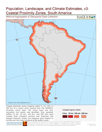
Map of coastal proximity zones in South America. PLACE III provides land area and urban and rural population estimates for people living within 200km, 100km, 10km, or 5km of their country’s coastline. |
Version 3 of the Population, Landscape, and Climate Estimates data set (PLACE III) has been released as part the National Aggregates of Geospatial Data Collection, produced by the NASA Socioeconomic Data and Applications Center (SEDAC) operated by CIESIN. PLACE III provides national-level estimates of resident population and land area in relation to the environmental characteristics of their location (for example, by biome, climate zone, coastal proximity, and elevation) in a tabular format. Population estimates are available for 1990, 2000, and 2010 for 232 statistical areas (countries and other territories recognized by the United Nations). New features in version 3 are separate estimates for urban and rural populations and a pivot table to facilitate data selection and analysis.
The PLACE III data set is especially useful for those who are not familiar with specialized geospatial software and methods. The data set is organized so that users can quickly find the specific countries and variables of interest. It may be downloaded as an Excel spreadsheet or as a comma-separated file (CSV) that can be opened by any text editor. Spreadsheet users may filter data by country, urban or rural classification, and other categories such as geoRegion (a geographic entity defined by the UN, similar to continent), geoSubregion (regions smaller than continents but larger than countries), and income group or lending category (World Bank global classifications of poverty and lending attractiveness).
Population and land area estimates have been generated for a variety of themes, including biomes of the world, climate classifications and predictions, elevation levels, distance from the coast, and population density zones. PLACE III facilitates comparative research at the national level by providing access to a range of useful summary variables on such questions as approximately how many people live within 10 kilometers of the coastline in South American countries; roughly how many rural Africans live in deserts and xeric shrublands; or how populations are distributed by elevation in southern Asia. Data from previous versions of PLACE have been used and cited in a number of scientific articles in both the natural and social sciences.
SEDAC Web Site Improved
October 5, 2012SEDAC has released a new version of its Web site with several important enhancements. A new theme menu option enables users to view only those data and information resources directly relevant to specific topics such as agriculture and food security; climate impacts, vulnerability, and adaptation; and hazards and disaster risk. Users may also now view SEDAC data holdings at the collection level, i.e., by groups of related data sets, rather than by individual data set. Data downloads have been simplified, and a new map “widget” has been added to the map gallery to provide rapid browsing of available data layers. The new Web site also provides access to new and updated data sets on environmental indicators, historical sulfur dioxide emissions, and national-level population, landscape, and climate estimates (see Recent Releases on the home page).
New Data Initiatives Considered at Virginia and Colorado meetings
October 4, 2012Two new scientific data initiatives at national and international levels were the focus of meetings held October 1–3 in Arlington, Virginia and October 4-5 in Boulder, Colorado. CIESIN director Robert Chen participated in the first event, a planning meeting of the Research Data Alliance, a proposed new international initiative aimed at accelerating international data-driven innovation and discovery. The Alliance, which is expected to be formally launched in March 2013, is working to identify international partnerships and activities that would facilitate research data sharing and exchange, data discovery, use, and re-use, and coordination and harmonization of standards.
CIESIN senior digital archivist Robert Downs attended the second event, a National Science Foundation (NSF) principal investigator meeting for EarthCube, a NSF initiative to develop community-guided cyberinfrastructure to integrate data and information for knowledge management across the Geosciences. Held at the Cooperative Institute for Research in Environmental Sciences (CIRES) of the University of Colorado, the meeting brought together representatives from the geoscience research and education communities to discuss the development of EarthCube. Downs served as the co-facilitator and co-presenter, with Joel Cutcher-Gershenfeld of the University of Illinois at Urbana-Champaign, for a session on Education, Outreach, and Social Systems. He is also the lead of EarthCube’s Education and Workforce Development special interest group.
Wide Range of CIESIN Activities to be Featured at Upcoming Lamont-Doherty Open House
September 28, 2012CIESIN will again participate in the annual Lamont-Doherty Open House Saturday, October 6, 10 a.m. – 4 p.m. at the Lamont Campus of Columbia University in Palisades, New York. The Open House was begun several decades ago to educate and inform the general public, teachers, and students of all ages. Research facilities will be open and tents set up over several acres of the campus, offering diverse scientific exhibits, hands-on demonstrations, lectures, and other activities organized by hundreds of scientists, staff, and students from Columbia’s Earth Institute. CIESIN’s exhibits this year will include a live demonstration of the CHANGE viewer, a tool for mapping climate change prediction data and population information; posters and demonstrations about other CIESIN projects, tools, and data; and a hands-on mapping game for children. The Open House is suitable for individuals of all ages. “Kid friendly” exhibits will be specially identified. For more information or directions, see the Lamont-Doherty Web site.
Data Needs Related to IPCC Assessments Addressed in St. Petersburg, Russia
September 21, 2012Coordinated management of scientific data used in assessing climate change impacts, adaptation, vulnerability, and mitigation is the primary focus of an international team established by the Intergovernmental Panel on Climate Change (IPCC), the Task Group on Data and Scenario Support for Impact and Climate Analysis (TGICA). At the TGICA's 18th meeting, hosted September 18–20 by the Voeilov Main Geophysical Observatory in St. Petersburg in the Russian Federation, the TGICA reviewed current efforts to archive and disseminate the latest outputs from dozens of climate models, to develop consistent socioeconomic and emission scenarios for use in the IPCC's Fifth Assessment, and to update and expand the IPCC Data Distribution Centre (DDC). CIESIN director Robert Chen, in his capacity as an ex officio member of the TGICA and co-manager of the DDC, led discussions at the meeting on data needs of the international research community, approaches to data attribution, and development of regional entry points to the DDC. Senior staff associate Xiaoshi Xing also participated in the meeting to help plan changes to the DDC, which is co-managed by the NASA Socioeconomic Data and Applications Center (SEDAC) operated by CIESIN.
SEDAC Invites User Evaluation of Its Services
September 12, 2012Every year NASA conducts a survey of users of the Earth Observing System Data and Information System (EOSDIS) to assess their satisfaction with the data, tools, and support provided by EOSDIS data centers and services. SEDAC is one of the NASA EOSDIS centers evaluated by the survey. A limited number of SEDAC data users received an email invitation in early September from the CFI Group on behalf of NASA, asking them to participate in an anonymous, Web-based survey about the quality and utility of SEDAC products and services, and the ease of access to SEDAC resources. The questionnaire takes approximately 10 minutes to complete, and optional comment fields are provided to address user concerns.
SEDAC users who have not yet received an invitation directly are welcome to contact the CFI Group at nasasurvey@cfigroup.com, providing an email address and self-identifying as a SEDAC data user. Invitations should not be forwarded to others, but others may be referred to the above email address.
SEDAC encourages all of its users to participate in the survey. Feedback affects future performance, identifies high priority user needs and concerns, and helps to justify NASA's continuing investment in EOSDIS data services and support. Past surveys have provided important inputs into the development of the redesigned SEDAC Web site, and user comments help to further improve SEDAC data and services.
Experts Assess Role of Earth Observations in Meeting the Millennium Development Goals
September 6, 2012Bonn, Germany was the venue for the Second GEOSS Science and Technology Stakeholders Workshop August 28-31, which addressed the theme of "Supporting Science for the Millennium Development Goals and Beyond." The Group on Earth Observations (GEO) is coordinating international efforts to build a Global Earth Observing System of Systems (GEOSS), intended to improve access to and the use of Earth observations for a broad range of stakeholders. Alex de Sherbinin, senior research associate with CIESIN and deputy manager of the NASA Socioeconomic Data and Applications Center (SEDAC), gave a presentation on spatial poverty assessments, drawing in part on poverty mapping and related data available from SEDAC. The workshop focused on contributions by the GEO community to achieving the United Nations Millennium Development Goals (MDGs), featuring presentations and discussions on food and water security, natural disasters, and biodiversity and ecosystem services. A draft report is under development.
Spatial Data and Information Coordination Addressed in United Nations Experts Meeting
August 24, 2012Geospatial data and services have become invaluable resources for many international organizations like the United Nations and its agencies. At the Second Session of the United Nations Committee of Experts on Global Geospatial Information Management (UNCE-GGIM) held at UN Headquarters in New York City August 13-15, more than 180 representatives of member countries, UN bodies, and interested nongovernmental organizations met to coordinate and promote common practices, policies, mechanisms and standards for the interoperability of geospatial data and services. Associate director Mark Becker participated in the meeting as an observer representing CIESIN, which is a nongovernmental organization recognized by the UN Economic and Social Council (ECOSOC). Issues discussed at the meeting included preparation of a Global Map for Sustainability, adoption of a common global geodetic referencing system, development of regional spatial data infrastructures, and ethical issues related to the acquisition, distribution, and use of geospatial data.
CyberGIS Conference Highlights Space-Time Analysis, Modeling, and Synthesis
August 10, 2012CyberGIS'12, the First International Conference on Space, Time, and CyberGIS, brought together a range of researchers, educators, and practitioners to the University of Illinois at Urbana-Champaign August 6-9 to examine the state-of-the-art in developing cyberinfrastructure to advance geospatial sciences and technologies. CIESIN associate director Mark Becker was invited to participate in the Community Building session on the afternoon of August 6. Keynote speakers at the conference included Prof. Michael Goodchild, former chair of the User Working Group of the NASA Socioeconomic Data and Applications Center (SEDAC) operated by CIESIN, and Daniel Atkins, who was the first director of the Office of Cyberinfrastructure at the National Science Foundation. The conference was hosted by the The CyberInfrastructure and Geospatial Information Laboratory (CIGI) at the University of Illinois and the National Center for Supercomputing Applications (NCSA).
Strategies for Disasters, Risk Management, and Vulnerability in Argentina Explored
August 9, 2012CIESIN associate research scientist Susana Adamo was one of more than 50 participants in a "National Workshop on Disasters, Risk Management and Vulnerability: Strengthening the Integration of Natural and Social Sciences with Managers" held in Buenos Aires July 31. The workshop addressed the need for a common and up-to date information system, available to all risk managers at the national, provincial and municipality levels, and for a national coordination strategy among different scientific and technical institutions and organizations for decision making in the event of natural disasters. Adamo addressed the issue of identifying and characterizing key indicators of social vulnerability to disasters in her presentation and led a working group on this topic. The workshop was organized by the National Directorate of Civil Protection and the National Research Council of Argentina, and sponsored by the Ministry of Interior and Transportation and the Ministry of Science, Technology and Innovation.
New Research Explores Links Between Rainfall and Migration
July 31, 2012
|
“Where the Rain Falls,” a project led by the development non-governmental organization CARE, working with the United Nations University (UNU) and CIESIN, has released a new set of case studies and associated maps examining the interplay between rainfall patterns, food security, and human mobility. Field research was conducted in eight countries—Bangladesh, India, Guatemala, Peru, Ghana, Tanzania, Thailand and Vietnam—using participatory research, household surveys, and expert interviews. The research aims to answer the question, Under what circumstances do households use migration as a risk management strategy in response to increasing rainfall variability and food insecurity?
This is the second time that CIESIN has partnered with CARE and UNU to produce maps that complement findings from ground-based research on climate change and migration. In 2009 they produced the maps and data visualizations for In Search of Shelter. The integration of data from multiple sources in visually attractive maps helps tell the story about migration in a way that written narratives alone cannot accomplish.
Annapolis Workshop Highlights Data Visualization Approaches for Human-Environment Studies
July 27, 2012An international group of multidisciplinary researchers and computer scientists met in Annapolis July 23–24 to discuss the visualization of socio-environmental systems, with examples drawn from urban design for sustainability and climate change to biodiversity conservation. The workshop was hosted by the recently established National Socio-Environmental Synthesis Center (SESYNC), a multi-year NSF synthesis center. CIESIN senior research associate and SEDAC deputy director Alex de Sherbinin presented a poster on CIESIN and SEDAC data visualization, using examples from the SEDAC map gallery, research on climate change and migration, the Environmental Performance Index, and the SEDAC map client. He also gave a short presentation on various SEDAC data products. Keynote presentations were given by Ben Schneiderman of University of Maryland and Stephen Sheppard of the University of British Columbia.
| 30 of 36 |