West Africa Coastal Vulnerability Mapping
To measure human security and sensitivity of populations to climate stressors in the coastal zone of West Africa.
|
|
Global Rural-Urban Mapping Project (GRUMP), v1

To provide a raster representation of urban areas (or urban mask) for use with GRUMP population grids or other data sets.
|
Last of the Wild, v2
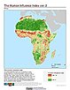
To provide an updated map of anthropogenic impacts on the environment in geographic projection which can be used in wildlife conservation planning, natural resource management, and research on human-environment interactions.
|
|
Last of the Wild, v2
To provide an updated map of anthropogenic impacts on the environment in Interrupted Goode Homolosine Projection which can be used in wildlife conservation planning, natural resource management, and research on human-environment interactions.
|
Last of the Wild, v2
To provide an updated map of anthropogenic impacts on the environment in the Interrupted Goode Homolosine Projection which can be used in wildlife conservation planning, natural resource management, and research on human-environment interactions.
|
|
Last of the Wild, v2
To provide an updated map of anthropogenic impacts on the environment in geographic projection which can be used in wildlife conservation planning, natural resource management, and research on human-environment interactions.
|
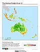
Last of the Wild, v1
To provide a map of anthropogenic impacts on the environment in geographic projection which can be used in modeling efforts, wildlife conservation planning, natural resource management, policy-making, biodiversity studies and human-environment interactions.
|
|
Last of the Wild, v1
To provide a map of anthropogenic impacts on the environment in the Interrupted Goode Homosoline Projection which can be used in wildlife conservation planning, natural resource management, and research on human-environment interactions.
|