Search » Data Sets (300)
| 5 of 15 |
Subset of DMSP-OLS Nighttime Lights for Economic Activity, v1 (2010)West Africa Coastal Vulnerability MappingTo provide a measure of economic activity in the coastal zone of West Africa based on nighttime lights. |
Commercial Crop Production, v1 (2000)West Africa Coastal Vulnerability MappingTo provide crop production for five higher-value export crops in West Africa to aid in estimating production value. |
|
Economic Systems Index, v1 (2000, 2010)West Africa Coastal Vulnerability MappingTo assess relative levels of economic activity in the coastal zone of West Africa. |
Point and Gridded Locations of Fatalities, v1 (
|
|
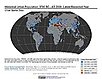
Historical Urban Population, v1 (
|
Global Fire Emissions Indicators, Country-Level Tabular Data, v1 (
|
|
Natural Resource Protection and Child Health Indicators, 2018 Release (
|
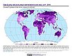
UN WPP-Adjusted Population Density, v4.11 (2000, 2005, 2010, 2015, 2020)Gridded Population of the World (GPW), v4
To provide estimates of population density for the years 2000, 2005, 2010, 2015, and 2020, based on counts consistent with national censuses and population registers with respect to relative spatial distribution, but adjusted to match United Nations country totals. |
|
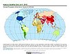
Population Density, v4.11 (2000, 2005, 2010, 2015, 2020)Gridded Population of the World (GPW), v4
To provide estimates of population density for the years 2000, 2005, 2010, 2015, and 2020, based on counts consistent with national censuses and population registers, as raster data to facilitate data integration. |
Basic Demographic Characteristics, v4.11 (2010)Gridded Population of the World (GPW), v4To provide estimates of population counts by age and sex for the year 2010, consistent with national censuses and population registers, as raster data to facilitate data integration. |
|
Population Count, v4.11 (2000, 2005, 2010, 2015, 2020)Gridded Population of the World (GPW), v4
To provide estimates of population count for the years 2000, 2005, 2010, 2015, and 2020, consistent with national censuses and population registers, as raster data to facilitate data integration. |
||
Administrative Unit Center Points with Population Estimates, v4.11 (2000, 2005, 2010, 2015, 2020)Gridded Population of the World (GPW), v4To provide a vector (point) version of the input administrative units used in GPWv4 with population estimates, densities, 2010 basic demographic characteristics, and administrative name, area, and data context for use in data integration. |
||
UN WPP-Adjusted Population Count, v4.11 (2000, 2005, 2010, 2015, 2020)Gridded Population of the World (GPW), v4
To provide estimates of population count for the years 2000, 2005, 2010, 2015, and 2020, consistent with national censuses and population registers with respect to relative spatial distribution, but adjusted to match United Nations country totals. |
||
Environmental Performance Index, 2018 Release (
|
India Village-Level Geospatial Socio-Economic Data Set, v1 (1991, 2001)India Data Collection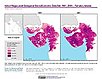
To provide data that can be used in independent spatial statistical analyses, construction of development-related indices, or in combination with remote sensing data in order to identify spatio-temporal patterns and/or changes in different demographic categories, such as male, female, urban, rural, level of education, etc. |
|
| 5 of 15 |