Search » Data Sets (162)
| 8 of 9 |
Global Mangrove Forests Distribution, v1 (2000)Land Use and Land Cover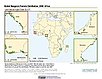
To provide data that can be used in global mangrove forest distribution modeling, land cover change analysis, global carbon accounting studies and to assist with policy-making in regards to human-environment interactions and future adaptive strategies. |
Population Count Grid, v3 (1990, 1995, 2000)Gridded Population of the World (GPW), v3To provide a time series of raster data on population to facilitate data integration. |
|
Population Density Grid Future Estimates, v3 (2005, 2010, 2015)Gridded Population of the World (GPW), v3To provide a time series of raster data on population projected to the year 2015 to facilitate data integration. |
Population Count Grid Future Estimates, v3 (2005, 2010, 2015)Gridded Population of the World (GPW), v3To provide a time series of raster data on population projected to the year 2015 to facilitate data integration. |
|
National Identifier Grid, v3 (2000)Gridded Population of the World (GPW), v3To provide a raster representation of nation-states in GPWv3 for use in aggregating population data. |
Population Density Grid, v3 (1990, 1995, 2000)Gridded Population of the World (GPW), v3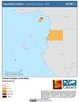
To provide a time series of raster data on population density to facilitate data integration. |
|
Land and Geographic Unit Area Grids, v3 (1990, 1995, 2000, 2005, 2010, 2015)Gridded Population of the World (GPW), v3To provide a quantitative measure of the input resolution of administrative units used for GPWv3. |
U.S. Population Grids (Summary File 3): Alabama, Louisiana, and Mississippi, alpha (2000)Natural DisastersTo provide gridded demographic data, including characteristics of income, poverty, education, and housing age, for Alabama, Louisiana and Mississippi. |
|
U.S. Population Grids (Summary File 1): New Orleans Metropolitan Statistical Area, alpha (2000)Natural Disasters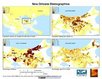
To provide gridded demographic data, including characteristics of age, race, ethnicity, and housing, for metropolitan statistical areas at a finer resolution than is available in the 30 arc-second grids used for the United States as a whole. |
U.S. Population Grids (Summary File 3): New Orleans Metropolitan Statistical Area, alpha (2000)Natural DisastersTo provide gridded demographic data, including characteristics of income, poverty, education, and housing age, for New Orleans. |
|
U.S. Population Grids (Summary File 1): Houston Metropolitan Statistical Area, alpha (2000)Natural Disasters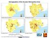
To provide gridded demographic data, including characteristics of age, race, ethnicity, and housing, for metropolitan statistical areas at a finer resolution than is available in the 30 arc-second grids used for the United States as a whole. |
U.S. Population Grids (Summary File 1): Alabama, Louisiana, Mississippi and Texas, alpha (2000)Natural DisastersTo provide gridded demographic data, including characteristics of age, race, ethnicity, and housing, for Alabama, Louisiana, Mississippi and Texas. |
|
Global 15 x 15 Minute Grids of the Downscaled Population Based on the SRES B2 Scenario, v1 (1990, 2025)Socioeconomic Downscaled Projections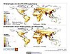
To provide a gridded data on country-level population and downscaled projections based on the SRES B2 marker scenario. |
Global 15 x 15 Minute Grids of the Downscaled GDP Based on the SRES B2 Scenario, v1 (1990, 2025)Socioeconomic Downscaled Projections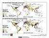
To provide gridded GDP data on country-level downscaled projections based on the SRES B2 marker scenario. |
|
Global Patterns of HANPP, v1 (1995)Human Appropriation of Net Primary Productivity (HANPP)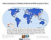
To assist in understanding human impacts on the environment, and especially impacts on biodiversity and ecosystem services. |
Global Patterns in Net Primary Productivity, v1 (1995)Human Appropriation of Net Primary Productivity (HANPP)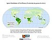
To be utilized in conjunction with a data set of human appropriation of net primary productivity (HANPP) in order to understand global energy flows and localized impacts on the environment. |
|
HANPP as a Percentage of Net Primary Productivity, v1 (1995)Human Appropriation of Net Primary Productivity (HANPP)
To identify spatial variations in the amount of NPP consumption relative to local production in a way that highlight humanity's growing impact on the biosphere. |
Global Human Footprint (Geographic), v1 (
|
|
Global Human Footprint (IGHP), v1 (
|
1x1 Degree Gridded Emissions, v1 (
|
| 8 of 9 |