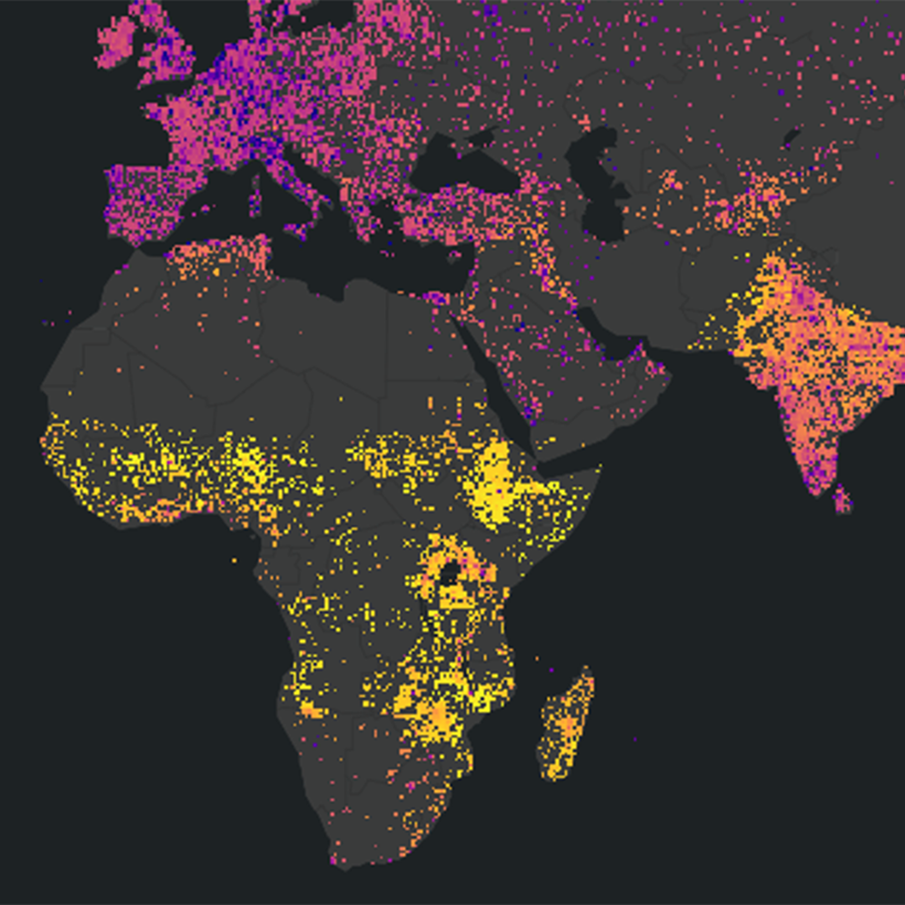
NASA Website Socioeconomic Data and Applications Center (sedac)
A Data Center in NASA's Earth Observing System Data and Information System (EOSDIS) — Hosted by CIESIN at Columbia University
Data
  • Data Sets
  • Maps
  • Web Pages
  • home
  • Data
    • · Data Sets
    • · Data Collections
    • · Featured Data Uses
    • · Data Citations
    • · Citations Database
    • · Data Submission
  • Maps
    • · Map Gallery
    • · Map Viewer
    • · Map Services
    • · Mapping Tools
  • Themes
    • · Agriculture
    • · Climate
    • · Conservation
    • · Governance
    • · Hazards
    • · Health
    • · Infrastructure
    • · Land Use
    • · Marine and Coastal
    • · Population
    • · Poverty
    • · Remote Sensing
    • · Sustainability
    • · Urban
    • · Water
  • Resources
    • · Guides
    • · Multimedia
    • · Networks
    • · News
    • · Publications
    • · Related Sites
    • · Remote Sensing
    • · Tools
  • Social Media
    • · Twitter
    • · FaceBook
    • · YouTube
    • · Flickr
    • · Blog Posts
    • · Communities
  • About
    • · About SEDAC
    • · User Working Group
    • · Privacy
    • · User Registration
  • Help
 

Applications of Satellite Remote Sensing

Follow Us: Twitter Follow Us on Facebook YouTube Flickr   |   Share: Twitter Facebook
  • Theme Home
  • Data Sets
  • Map Gallery
  • Map Services
  • Featured Data Uses
  • Resources
    • Guides
    • Multimedia
    • Networks
    • Publications
    • Related Sites
    • Remote Sensing

Research Applications of SEDAC Data

Research Applications of SEDAC Data

This presentation by SEDAC deputy manager Alex de Sherbinin describes research he has conducted either using SEDAC data or to develop SEDAC-disseminated data sets. The lecture was given to the Pennsylvania State University Department of Geography coffee hour in February 2020.

NASA EarthData Webinar: Remote Sensing-Derived Environmental Indicators for Decision Making

thumbnail

Results of a NASA-funded pilot study to develop satellite-derived indicators in three issues areas—ambient air pollution, coastal eutrophication, and biomass burning—are presented, in the context of what makes an indicator that passes muster with policy and technical audiences, and the underlying satellite data and methodologies. Part of the monthly NASA Earthdata Webinar Series that highlights NASA EOSDIS data products and data access tools.

Webinar: Explore NASA Socioeconomic Data Using Web Mapping Services

Webinar: Explore NASA Socioeconomic Data Using Web Mapping Services

This overview of integrating socioeconomic and remote sensing data to explore human interactions in the environment is part of the monthly NASA Earthdata Webinar Series that showcases NASA EOSDIS data products and data access tools. Also available via Adobe Connect.

Home | Data | Data Uses | Data Citations | Maps | Map Services

News | Tools | Guides | Publications | Blog Posts

About | Help | Privacy | User Registration

Copyright © 1997–2021. The Trustees of Columbia University in the City of New York.

WDS ICSU