NASA Website Socioeconomic Data and Applications Center (sedac)
A Data Center in NASA's Earth Observing System Data and Information System (EOSDIS) — Hosted by CIESIN at Columbia University
Data
  • Data Sets
  • Maps
  • Web Pages
  • home
  • Data
    • · Data Sets
    • · Data Collections
    • · Featured Data Uses
    • · Data Citations
    • · Citations Database
    • · Data Submission
  • Maps
    • · Map Gallery
    • · Map Viewer
    • · Map Services
    • · Mapping Tools
  • Themes
    • · Agriculture
    • · Climate
    • · Conservation
    • · Governance
    • · Hazards
    • · Health
    • · Infrastructure
    • · Land Use
    • · Marine and Coastal
    • · Population
    • · Poverty
    • · Remote Sensing
    • · Sustainability
    • · Urban
    • · Water
  • Resources
    • · Guides
    • · Multimedia
    • · Networks
    • · News
    • · Publications
    • · Related Sites
    • · Remote Sensing
    • · Tools
  • Social Media
    • · Twitter
    • · FaceBook
    • · YouTube
    • · Flickr
    • · Blog Posts
    • · Communities
  • About
    • · About SEDAC
    • · User Working Group
    • · Privacy
    • · User Registration
  • Help
 

Population Dynamics

Follow Us: Twitter Follow Us on Facebook YouTube Flickr   |   Share: Twitter Facebook
  • Collection Overview
  • Data Sets (7)
  • Map Gallery (54)
  • Map Services (29)
  • Citations
1 of 1
Prev | Next

Georeferenced U.S. County-Level Population Projections, Total and by Sex, Race and Age, Based on the SSPs, v1 (2020 – 2100)

Population Dynamics

  • Overview
  • Download
  • Documents

To provide subnational (county) population projection scenarios for the United States essential for understanding long-term demographic changes, planning for the future, and decision-making in a variety of applications.

Global 1-km Downscaled Population Base Year and Projection Grids Based on the SSPs, v1.01 (2000 – 2100)

Population Dynamics

  • Overview
  • Download
  • Documents
  • (3) Maps
  • (3) WMS

To provide global urban, rural, and total population base year and projection grids based on the Shared Socioeconomic Pathways (SSPs) data at a resolution of 1-km (about 30 arc-seconds) for climate, socioeconomic, environmental, and other related research.

Global One-Eighth Degree Population Base Year and Projection Grids Based on the SSPs, v1.01 (2000 – 2100)

Population Dynamics

  • Overview
  • Download
  • Documents
  • (12) Maps
  • (15) WMS

To provide global urban, rural, and total population base year and projection grids based on the Shared Socioeconomic Pathways (SSPs) data at a resolution of one-eighth degree (7.5 arc-minutes) for climate, socioeconomic, environmental, and other related research.

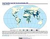
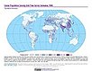
Latin America and the Caribbean Population Time Series, v1 (1990, 2000)

Population Dynamics

  • Overview
  • Download
  • Documents

To describe changing population distribution and growth in Latin America and the Caribbean using spatially consistent and comparable units at a spatial resolution suitable to regional change analysis.

Global Population Count Grid Time Series Estimates, v1 (1970 – 2000)

Population Dynamics

  • Overview
  • Download
  • Documents
  • (4) Maps
  • (4) WMS

To provide back-cast population count estimates at 30 arc-second (~1 km) resolution.

Global Population Density Grid Time Series Estimates, v1 (1970 – 2000)

Population Dynamics

  • Overview
  • Download
  • Documents
  • (4) Maps
  • (4) WMS

To provide back-cast population density estimates at 30 arc-second (~1 km) resolution.

Global Estimated Net Migration Grids By Decade, v1 (1970 – 2000)

Population Dynamics

  • Overview
  • Download
  • Documents
  • (18) Maps
  • (3) WMS

To provide estimates of net-migration (in-migration minus out-migration) per one-kilometer grid cell on a decadal basis for the 1970s, 1980s, and 1990s.

1 of 1
Prev | Next

Home | Data | Data Uses | Data Citations | Maps | Map Services

News | Tools | Guides | Publications | Blog Posts

About | Help | Privacy | User Registration

Copyright © 1997–2023. The Trustees of Columbia University in the City of New York.

WDS ICSU