Data Sets (9)
|
1 of 1
Prev
|
Next
|
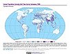
Population (POP), Built-Up Estimates (BUILT), and Degree of Urbanization Settlement Model Grid (SMOD), v1 (1975, 1990, 2000, 2014, 2015)Global Human Settlement Layer (GHSL)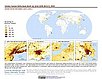
To provide global data on human population, built up area, and degree of urbanization for the years 1975, 1990, 2000, and 2014/2015 in the World Geodetic System 1984 (WGS84) geographic coordinate system. |
||
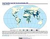
Population Count Grid, v1 (1990, 1995, 2000)Global Rural-Urban Mapping Project (GRUMP), v1To provide a time series of raster population data for ntegration with other data sets. |
Population Density Grid, v1 (1990, 1995, 2000)Global Rural-Urban Mapping Project (GRUMP), v1
To provide a time series of raster population density data for data integration. |
|
U.S. Population Grids (Summary File 1): New Orleans Metropolitan Statistical Area, alpha (2000)Natural Disasters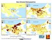
To provide gridded demographic data, including characteristics of age, race, ethnicity, and housing, for metropolitan statistical areas at a finer resolution than is available in the 30 arc-second grids used for the United States as a whole. |
U.S. Population Grids (Summary File 3): New Orleans Metropolitan Statistical Area, alpha (2000)Natural DisastersTo provide gridded demographic data, including characteristics of income, poverty, education, and housing age, for New Orleans. |
|
U.S. Population Grids (Summary File 1): Houston Metropolitan Statistical Area, alpha (2000)Natural Disasters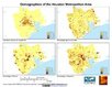
To provide gridded demographic data, including characteristics of age, race, ethnicity, and housing, for metropolitan statistical areas at a finer resolution than is available in the 30 arc-second grids used for the United States as a whole. |
|
1 of 1
Prev
|
Next
|