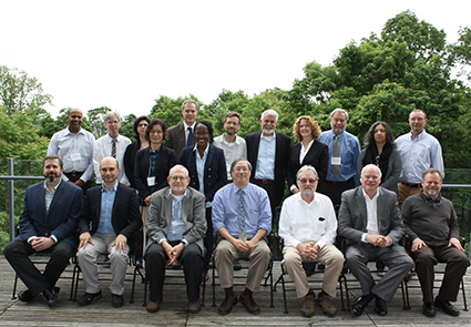
Greg Yetman, associate director for geospatial applications, attended the SERVIR West Africa annual work plan meeting at the Agriculture, Hydrology and Meteorology (AGRHYMET) Regional Center in Niamey, Niger, August 1-2. CIESIN is an implementing partner of the West Africa node of SERVIR, a joint development initiative of NASA and the U.S. Agency for International Development (USAID). The meeting brought together consortium members from West Africa, prime contractor Tetra Tech, and USAID staff to review progress and plan work items for the coming year. The primary focus is the development of services in support of environmental monitoring in key areas related to charcoal production and deforestation, desertification, agriculture and food production, and land use/land cover change. A workshop on geospatial data and metadata is planned in September in Accra, Ghana. Established in 1974, AGRHYMET is a specialized agency of the Permanent Inter-State Committee against Drought in the Sahel (CILSS).
Resources »  News
News
| 12 of 36 |
Geospatial Data for Sustainable Development Addressed by United Nations Experts
August 4, 2017More than 85 countries and 70 international agencies and organizations were represented at the 7th Session of the United Nations Committee of Experts on Global Geospatial Information Management (UN-GGIM), held at UN Headquarters in New York July 31-August 4. The Session included a number of side events on key geospatial data topics related to disaster management, marine resources, planning of national censuses, and other aspects of sustainable development. CIESIN director Robert Chen participated in the August 1 side event, "The 2030 Agenda for Sustainable Development: Where is the Data?," giving a brief presentation on recent efforts to develop a public-private partnership for human settlement, infrastructure, and population data, as part of a panel on "Data Solutions and Platforms for the Sustainable Development Goals." The panel was moderated by Sanjay Kumar, chair of the UN-GGIM's Private Sector Network, and included Anne Hale Miglarese of Radiant Earth, Peter Rabley of the Omidyar Network, and Vincent Seaman of the Bill & Melinda Gates Foundation. Chen and deputy director Marc Levy attended another August 1 side event, on Second Administrative Level Boundaries (SALB), and Chen participated in an August 3 meeting of the UN-GGIM Academic Network. Geographic information specialists Malanding Jaiteh and Dara Mendeloff, together with geographic information system programmer Kytt MacManus, also attended selected sessions and side events during the week.
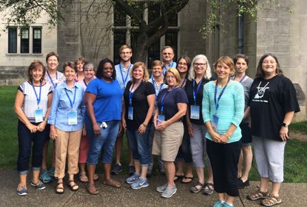
Earth Science Data Experts Connect with Teachers and Data Users
July 31, 2017
|
|
Participants in the ESIP Educators Workshop at Indiana University, Bloomington, Indiana, July 27, 2017, including members of the ESIP Education Committee. Robert Downs, CIESIN senior digital archivist, is in the back row, center right. |
Robert Downs, CIESIN senior digital archivist, joined more than 250 Earth science data experts at the summer meeting of the Earth Science Information Partners (ESIP) at Indiana University in Bloomington, Indiana July 25-28. The meeting continued the 2017 ESIP focus on the theme, "Strengthening the Ties Between Observations and User Communities." As part of an all-day educators workshop on "Drones, Data, and the Great American Eclipse," Downs demonstrated several different mapping tools for visualizing data related to hazards and population exposure, developed by the NASA Socioeconomic Data and Applications Center (SEDAC) operated by CIESIN. He also gave a presentation in the ESIP session, "What Do We Mean by 'Trusted' Data?," on the topic, "Trusted Data for Disaster Management," co-authored with CIESIN director Robert Chen and Gregory Yetman, associate director for geospatial applications.
In a session focused on evaluating options for becoming a trusted data repository, Downs presented "Adopting World Data System Certification to Improve a Trustworthy Data Repository," co-authored with Chen and Alex de Sherbinin, associate director for science applications. The presentation summarized the certification process that SEDAC completed to become a Regular Member of the International Council for Science World Data System (ICSU-WDS). He also presented a poster depicting SEDAC citation metrics in a special "Research As Art" session held at the Wonderlab, a science museum in downtown Bloomington. Downs serves as the Type I representative on the ESIP Governance Committee.
World Bank Launches Atlas of Sustainable Development Goals
July 19, 2017The World Bank Group has launched the 2017 Atlas of Sustainable Development Goals, an interactive data platform and publication aimed at charting the progress that countries are making towards the Sustainable Development Goals (SDGs) that were adopted by the international community in September 2015. The Atlas illustrates trends and challenges for each goal, drawing on the Bank's existing World Development Indicators database and highlighting ongoing measurement challenges. At a July 18 breakfast event in conjunction with the 2017 High-Level Political Forum on Sustainable Development in New York, Umar Serajuddin, senior economist with the World Bank Group, gave an overview of the Atlas and its potential use by the sustainable development community. His Excellency Juan Carlos Mendoz Garcia, Permanent Representative of Costa Rica to the UN, together with Stefan Schweinfest, Director of the UN Statistics Division, and Robert Chen, CIESIN director, then commented on the Atlas, focusing in part on its complementarity to other SDG-related data reports such as the recently released UN Sustainable Development Goals Report 2017. The panel discussion was moderated by Mahmoud Mohieldin, senior vice president for the 2030 Development Agenda, United Nations Relations, and Partnerships at the World Bank Group.
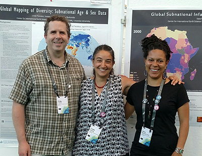
New Geospatial Data and Tools Featured at Annual Esri User Conference
July 14, 2017
|
|
CIESIN associate director for geospatial applications Greg Yetman (left) and geographic information specialists Linda Pistolesi (center) and Dara Mendeloff (right) showcase some of the posters they helped to develop, at the ESRI User Conference Map Gallery Reception July 10–17, 2017, in San Diego CA. |
The annual Esri User Conference reportedly drew nearly 18,000 geospatial data and software users to San Diego July 10-14. Three CIESIN geospatial experts gave presentations and posters and staffed an exhibit booth. Greg Yetman, associate director for geospatial applications, gave an invited presentation on spatial data for the Sustainable Development Goals (SDGs) in a July 12 meeting of the SDG Special Interest Group. He also presented a poster on a new data resource on impervious surfaces and human built-up and settlement extents developed by researchers from NASA's Goddard Space Flight Center and the University of Maryland. The Global Man-made Impervious Surface (GMIS) and Human Built-up and Settlement Extent (HBASE) data sets are based on Landsat 8 images circa 2010 and will be made available through an interactive data visualization and access interface, now in beta testing, from the NASA Socioeconomic Data and Applications Center (SEDAC) operated by CIESIN. The poster was co-authored with: Sri Vinay, CIESIN associate director for information technology; Kytt MacManus, geographic information systems programmer; Frank Pascuzzi, programmer; and Al Pinto, senior media designer, together with Panshi Wang and Chengquan Huang of the University of Maryland and Eric Brown de Colstoun of GSFC.
Geographic information specialists Dara Mendeloff and Linda Pistolesi also presented posters: Mendeloff′s on the forthcoming SEDAC data set, Global Subnational Infant Mortality Rates, v2 (2014), and Pistolesi′s on the addition of age and sex data to the recently released Gridded Population of the World v4 data collection. The latter was co-authored with research scientist Susana Adamo and senior research assistant Olena Borkovska.
- “Global Subnational Infant Mortality Rates, v2 (2014)” (poster, 888KB PDF), D. Mendeloff
- “Global Mapping of Diversity: Subnational Age & Sex Data” (poster, 871KB PDF), L. Pistolesi, S. Adamo, and O. Borkovska
- “Data Visualization and Access Services for Global Man-made Impervious Surface (GMIS) and Human Built-up and Settlement Extent (HBASE) Data Sets” (poster, 1 MB PDF), G. Yetman et al
Hazard Researchers and Practitioners Convene in Colorado
July 13, 2017More than 500 hazard researchers, professionals involved in hazard response and mitigation, students, journalists, and representatives of key government and private sector organizations met in Broomfield, Colorado, July 9–12 for the 42nd annual Natural Hazards Research and Applications Workshop. The annual workshop, organized by the Natural Hazards Center at the University of Colorado-Boulder, is a unique forum for interaction between researchers and practitioners involved in improving understanding and management of hazards and efforts to reduce the impacts and risks of disasters. CIESIN director Robert Chen participated in a panel, “Keeping Count: Deaths, Damage, and Dollars Lost from Disasters," highlighting the role of remote sensing and population and infrastructure data in assessing and tracking hazard exposure, vulnerability, and impact. He also participated July 9 in a working meeting of directors, funders, and partners of hazards and disaster centers, aimed at promoting coordination and collaboration across the academic community, relevant Federal agencies, and other key organizations. The theme of the 2017 workshop was “Knowledge to Action: Reducing Hazards Losses and Promoting Disaster Resilience.″
New Application Supports Integrated Access to Population and Remote Sensing Data
July 10, 2017A new application lets users more easily and efficiently access and transform remote sensing data on land cover and land use change together with spatial population data. Released by the NASA Land Processes Distributed Active Archive Center (LP DAAC) in collaboration with the Socioeconomic Data and Applications Center (SEDAC) operated by CIESIN, Version 1.9 of the Application for Extracting and Exploring Analysis Ready Samples (AppEEARS) leverages two data sets from the SEDAC Gridded Population of the World v4 data collection. AppEEARS enables users to subset data spatially, temporally, and by layer, reducing the volume of data they need to download for analysis. When a request is submitted to AppEEARS, users receive sample data values and associated quality data for data products of interest. Users may then preview and interact with their sample before actually downloading the full set of data of interest. Integrated access to LP DAAC data about land processes with SEDAC data on population distribution facilitates interdisciplinary analysis of interactions between environmental and human systems.
Step-by-step instructions for how to use AρρEEARS and a full listing of available products may be found on the AppEEARS Help page. Additional resources for using AρρEEARS and its services are available on the LP DAAC E-Learning page. For questions, contact LP DAAC User Services (lpdaac@usgs.gov). LP DAAC and SEDAC are two of the data centers in the NASA Earth Observing System Data and Information System.
WorldPop Project Holds Second Annual Workshop in Winchester, England
June 30, 2017CIESIN staff members Greg Yetman, Linda Pistolesi, and Jane Mills traveled to Winchester, England, for the second annual WorldPop Global Development Workshop June 26–29. The main goal of the meeting was to review data inputs, review and revise the methodology for modeling population, and discuss the system design for delivering the project outputs. Yetman, associate director for geospatial applications, summarized CIESIN′s contributions to the project to date for both the workshop participants and the Project Advisory Committee. He, geographic information specialist Pistolesi, and senior research staff assistant Mills worked with partners at the workshop on technical issues and final plans. Initiated in late 2013, WorldPop is a project to develop detailed and open access population distribution data sets built using transparent approaches. With support from the Bill and Melinda Gates Foundation, an international team from the University of Southampton, the University of Louisville, and CIESIN is working to update and extend the WorldPop database to cover all countries, using a consistent methodology with a time series of population estimates, including age and sex ratio breakdowns.
Sharing of Earth Observation Data Addressed in TransAtlantic Working Group Meeting
June 23, 2017The annual meeting of the Group on Earth Observations (GEO) Data Sharing Working Group (DSWG) was held June 21 and 22 in two separate locations, Helsinki, Finland, and Palisades, New York. Taking into consideration a seven-hour time difference between the meeting sites, plenary sessions were held each day via video and telecon. Separate breakout group meetings were then held at each location, focused on specific issues such as international trends in open data sharing and building national capacity for data sharing. Robert Chen, CIESIN director, hosted the New York subgroup at Columbia′s Lamont campus in his capacity as one of the DSWG co-chairs. GEO is a voluntary partnership of national governments and participating organizations working together to improve decision-making informed through coordinated, comprehensive and sustained Earth observations. Improving data access and sharing has been a key GEO focus since it was established in 2005.
New Profiles Feature Yale's Karen Seto and CIESIN's Robert Chen
June 19, 2017The work of Karen Seto, associate dean for research and Frederick C. Hixon professor of geography and urbanization science at Yale University′s School of Forestry & Environmental Studies, is featured in a new User Profile on the NASA Earthdata web site. Seto is an active user of and contributor to the NASA Socioeconomic Data and Applications Center (SEDAC) operated by CIESIN. She served as a member of the SEDAC User Working Group from 2005 to 2011. Seto′s research focuses on urbanization and its effects on local and global environments, relying on both field and remotely-sensed data. Her data set, Global Grid of Probabilities of Urban Expansion to 2030, v.1 (2000-2030), developed with Burak Güneralp and Lucy Hutyra, is currently available from SEDAC. A second data set on long-term urban settlement growth, from 3700 BC to 2000 AD, will be released later this year. Seto recently received NASA funding for a project that will use multi-scale and multi-source satellite data to examine urban growth in the Hindu Kush Himalayan region.
Robert Chen, director of CIESIN and SEDAC's manager, discusses the role of geography and innovative geospatial data and technologies in a profile in Ubique, the newsletter of the American Geographical Society (AGS). One of Chen′s early SEDAC activities was to support development of the first global gridded data set on population distribution, Gridded Population of the World (GPW), created by geographers Waldo Tobler and Uwe Deichmann, then with the University of California-Santa Barbara. SEDAC released the fourth version of GPW in 2016. Chen′s recent collaborations include activities with Facebook′s Connectivity Lab on population mapping in rural areas, the New York Hall of Science on informal sustainability education, the Group on Earth Observations (GEO) and the Research Data Alliance (RDA) on open data sharing, and the United Nations Sustainable Development Solutions Network (UNSDSN) on sustainable development data. He joined the AGS Council in 2015.
Partnerships for Sustainable Development Data Highlighted at Columbia′s Casa Italiana
June 16, 2017
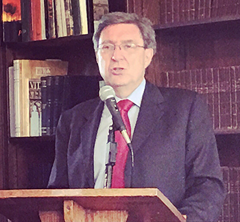
|
|
Enrico Giovannini, professor at University of Rome Tor Vergata, gives the keynote speech at “Navigating the Data Revolution: New Partnerships and Pathways Towards a World that Counts,” June 15, 2017 at Casa Italiana, Columbia University. |
“Navigating the Data Revolution: New Partnerships and Pathways Towards a World that Counts” was the topic of an evening event June 15 at Casa Italiana, co-sponsored by the United Nations (UN) Sustainable Development Solutions Network (SDSN), the Global Partnership for Sustainable Development Data, and the Italian Academy for Advanced Studies in America. Enrico Giovannini, professor at University of Rome Tor Vergata, gave a keynote speech, highlighting the challenges and opportunities facing the development data community since the 2014 publication of the influential report, A World That Counts, produced by the UN Secretary-General′s Independent Expert Advisory Group on the Data Revolution for Sustainable Development. Giovannini′s presentation was followed by a panel discussion on the need for new data partnerships and pathways, moderated by Shaida Badiee, managing director of Open Data Watch. Panelists were Laveesh Bhandari of the Indicus Foundation, CIESIN director Robert Chen, Chukwudozie Ezigbalike of the UN Economic Commission for Africa, and Jenna Slotin of the Global Partnership. The event was held in conjunction with the June 15–16 meeting of the SDSN′s Thematic Network on Data for Sustainable Development, which is co-chaired by Giovannini, Badiee, and Chen. Giovannini also chaired the 2014 group, which included Badiee and Chen as members.
CIESIN Welcomes New Staff and Summer Interns
June 8, 2017New personnel have joined CIESIN recently, including Markus Walsh, senior research scientist. Formerly Walsh was a senior research scientist with the Agriculture and Food Security Center of the Earth Institute, focused on ecosystems and landscape ecology. Prior to that, he was a senior research scientist for ten years at the World Agroforestry Center (ICRAF), where he led research on land degradation assessment, monitoring and rehabilitation in the Lake Victoria Basin, based in Kisumu, Kenya. He holds a PhD in rangeland ecology and management from Texas A&M University and BSc degrees in animal science and in agricultural mechanization from Iowa State University. Walsh grew up in Kenya and has more than 25 years of experience in ecosystems and landscape ecology research in Africa. Since joining the Earth Institute in 2007, his research has focused on developing operational tools for diagnosis, mapping and monitoring of the ecological condition of African landscapes with an emphasis on the application of information technology and data science in agriculture. He is based at the Selian Agricultural Research Institute in Arusha, Tanzania, where he is the science coordinator for the Africa Soil Information Service.
Also new to CIESIN is Ryan Marriott, who is program coordinator for the Millennium Villages data archiving project. Marriott worked on the Millennium Villages Project from January 2010 until June 2016. He has an MPA in energy and environmental policy from the School of International and Public Affairs, Columbia University, and a BA in economics from Macalester College.
Several interns have joined CIESIN for the summer. Anna Kaplan and Seyi Olojo, both rising seniors at Barnard College, are researching the relationship between infant mortality rates and the environment, as part of the creation of a new version of the Global Subnational Infant Mortality Rates (IMR) data set. They are working with Dara Mendeloff, CIESIN geographic information specialist, and Sandra Baptista, senior research associate. Majoring in environmental biology, Kaplan is part of the summer Earth Intern Program for Columbia University and Barnard College students, coordinated by Lamont research scientist Dallas Abbott. Olojo is a rising senior, majoring in environmental policy with a minor in statistics. She is a recipient of an Athena Summer Fellowship at Barnard. Last summer she was an Earth Intern, working with CIESIN deputy director Marc Levy.
Kira Topik is working with Alex de Sherbinin, associate director for science applications, on links between climate change, population distribution, and migration, in support of an ongoing project for the World Bank. A graduate of Pitzer College with dual BA degrees in international and intercultural studies and in Spanish, Topik will receive her MA from Columbia′s Climate and Society program in August. Previously she was a program officer in the Wildlife Conservation Society’s Latin America and Caribbean Program.
Satellites Enable Mapping of Nitrogen Dioxide Exposure for 1996 to 2012
June 7, 2017
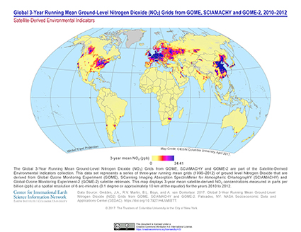
|
|
The map shows the 3-year mean satellite-derived NO2 concentrations for 2010 to 2012. |
Nitrogen dioxide (NO2) is major constituent in air pollution, with direct impacts on respiratory health and a key role as a chemical precursor in the overall air pollution mix. As a common by-product of internal combustion, outdoor NO2 pollution is mainly associated with motor vehicle traffic and energy production. A team of scientists led by Jeff Geddes and Randall Martin from Dalhousie University in Halifax, Canada, has produced a new data set that tracks long-term trends in ambient NO2 concentrations based on observations from three satellite instruments over the 17-year period, 1996–2012. The estimates of surface NO2 levels were validated against ground-based monitors and combined with the Gridded Population of the World version 3 (GPWv3) data set distributed by the NASA Socioeconomic Data and Applications Center (SEDAC) to produce a population-weighted time series of NO2 exposure. The data are now available from SEDAC as part of the data collection, Satellite Derived Environmental Indicators. The data set, Global 3-Year Running Mean Ground-Level NO2 Grids from GOME, SCIAMACHY and GOME-2, v1 (1996–2012), consists of a series of 0.1-degree latitude-longitude grids (approximately 10 x 10 km resolution) representing averages for overlapping 3-year periods. The grids for 1996–1998 and 2010–2012 may be visualized through the Web Mapping Service (WMS).
SEDAC has also recently released other new and updated data sets. The U.S. Census Grids Summary File 1, v1 (2010 ), provides grids for selected population and housing variables for the year 2010 consistent with previous grids released for 1990 and 2000 based on earlier U.S. censuses. These grids have a resolution of 30 arc-seconds (approximately 1 square km) and are based on census block geography from the Census 2010 TIGER/Line Files.
Settlement Points, v1.01 (1990, 1995, 2000), and Urban Extent Polygons, v1.01 (1995), are updates to human settlement data from the Global Rural-Urban Mapping Project (GRUMP) data collection. These revisions incorporate improved geospatial location information, new settlement points, and new urban extents identified from multiple sources. The Urban Extent Polygons data set now includes polygons in Esri shapefile format with the settlement name (or name of the largest city, in the case of multi-city agglomerations). Polygons are defined by the extent of night-time lights and approximated urban extents (circles) based on buffered settlement points.
For more information about these data sets, please see the links below.
User Working Group Advises on SEDAC Priorities
June 2, 2017
|
|
Members of the User Working Group of the NASA Socioeconomic Data and Applications Center (SEDAC) operated by CIESIN and several SEDAC staff members at the Lamont campus in Palisades, New York, May 31. |
The NASA Socioeconomic Data and Applications Center (SEDAC) operated by CIESIN hosted a technical interchange meeting of its User Working Group (UWG) May 31–June 1 to review progress and advise on strategic priorities. The meeting began with reports on recent SEDAC accomplishments and ongoing projects, followed by in-depth discussion of revised and proposed new priorities for SEDAC for the next five years. A joint breakout session was held via telecon with the UWG of the Land Processes-Distributed Active Archive Center (LP-DAAC) to discuss the accessibility of SEDAC data through the LP-DAAC's Application for Extracting and Exploring Analysis Ready Samples (AppEEARS). The LP-DAAC UWG was meeting simultaneously in Fort Collins, Colorado. The meeting also included presentations by two UWG members on recent approaches to the use of remote sensing data in the social sciences and in land cover/land use change research, as well as a guest lecture on big social science data and sustainable development by Emmanuel Letouzé of the Data-Pop Alliance. The first day of the meeting was held at the Lamont campus of Columbia University, and the second on the Morningside campus in Manhattan. Other participants included representatives from NASA headquarters and the Goddard Space Flight Center, and from the LP-DAAC and the Oak Ridge National Laboratory (ORNL) DAAC. Chaired by Myron Gutmann of the University of Colorado, the UWG has members from a diverse set of disciplines and application areas from both the public and private sectors.
Social Science Data Experts Explore Data′s Role in Research
May 26, 2017“Data in the Middle: the Common Language of Research” was the theme of the 2017 conference of the International Association for Social Science Information Services and Technology (IASSIST) in Lawrence, Kansas, May 23–26. At the meeting CIESIN senior digital archivist Robert Downs presented the paper, “Facilitating Integration of Socioeconomic and Remote Sensing Data to Support Interdisciplinary Research and Applications,” co-authored with CIESIN director Robert Chen. IASSIST is an international organization of data librarians, data managers, and other information technology professionals who support data management, research, and teaching in the social sciences. The conference was hosted this year by the University of Kansas, in collaboration with the Kansas University Libraries, the Institute for Policy and Social Research, and the Kansas City Federal Reserve Bank.
Climate Change, Disasters, and Migration Examined at United Nations Panel
May 24, 2017At United Nations (UN) headquarters in New York City May 23, CIESIN research scientist Susana Adamo participated as an expert speaker on a panel, “Adverse Effects of Climate Change and Natural Disasters as Drivers of Migration.” The panel was part of the informal second thematic session on addressing drivers of migration, including adverse effects of climate change, natural disasters, and human-made crisis, through actions such as protection and assistance, sustainable development, poverty eradication, and conflict prevention and resolution. Adamo was invited by the Office of the President of the General Assembly, which organized the panel with the UN Office of the Special Representative of the Secretary-General. This panel, together with a May 16 academic panel on climate change, migration, and displacement organized by the United Nations University (UNU), supported the Preparatory Process for the Global Compact for Migration. The call for the Global Compact follows the adoption in 2016 of the New York Declaration for Refugees and Migrants, in which the 193 UN Member States recognized the need for a comprehensive approach to human mobility and enhanced cooperation at the global level.
Online Seminar Explores Interactions between Demography, Culture, and Environment
May 19, 2017How demographic shifts, evolving cultural values and beliefs, and the changing environment may interact was the focus of an online “cyberseminar″ hosted by the Population and Environment Research Network (PERN) May 15–19, organized by CIESIN and the Columbia Aging Center. The cyberseminar began May 15 with a webinar hosted by Future Earth that summarized the background paper and introduced the themes addressed by panelists. Webinar presenters were Vegard Skirbekk of the Columbia Aging Center and the Norwegian Institute of Public Health, and PERN coordinators, Susana Adamo, CIESIN research scientist, and Alex de Sherbinin, associate director for science applications. They presented a paper co-authored with Tricia Chai-Onn, CIESIN geographic information specialist. Other invited experts provided comments on specific topics: Raya Muttarak of the International Institute for Applied Systems Analysis (IIASA) on ethnic and religious affiliation as they relate to vulnerability to natural hazards; Richard Wilk of the Department of Anthropology, Indiana University, on culture and environmentally significant consumption; and Tom Dietz of the Department of Sociology, Michigan State University, and Rachael Shwom of the Department of Human Ecology, Rutgers University, on culture, environmental risk perception, and behavior. Additional comments by experts from around the world have been posted to the cyberseminar discussion list.
The mission of PERN is to advance academic research on population and the environment by promoting online scientific exchange among researchers from social and natural science disciplines worldwide. PERN is a scientific panel of the International Union for the Scientific Study of Population (IUSSP) and a sustained partner of Future Earth, an international initiative to advance global sustainability science.
CIESIN Addresses Data Needs in Africa
May 19, 2017
|
|
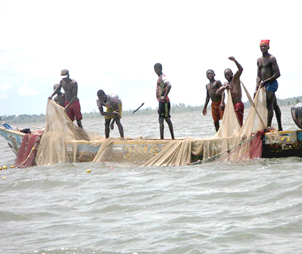
Sylwia Trzaska Fisherman off the coast of Sierra Leone, West Africa. CIESIN led a vulnerability assessment of the fishing communities of Sierra Leone for the West Africa Biodiversity and Climate Change (WA-BiCC) project. |
Awareness is growing of the vital importance of evidence-based decision making in Africa, for example, in agricultural development, natural resource management, and climate vulnerability assessment. CIESIN continues to work actively to address key African data needs through a number of different projects and initiatives, including the Africa Soil Information Service (AfSIS) funded by the Bill and Melinda Gates Foundation (BMGF) and operated by Rothamsted Research; the West Africa Biodiversity and Climate Change (WA-BiCC) project of the U.S. Agency for International Development (USAID); and the West Africa SERVIR hub being established jointly by USAID and NASA.
AfSIS is helping several African countries establish national soil information systems and services based on a range of new technologies. Senior research scientist Markus Walsh and deputy director Marc Levy manage CIESIN’s component of AfSIS, which is utilizing soil infrared spectroscopy, remote sensing, crowdsourcing, and other methods to accelerate development of digital soil maps. Such maps support efforts in partner countries Ethiopia, Ghana, Nigeria, and Tanzania to intensify agricultural production sustainably. Ethiopia, for example, has been able to formulate five fertilizer blends and target their use geographically, which is more effective and less harmful than the single blend formerly in use. Swetha Ramaswamy, education and outreach coordinator for AfSIS, is spending more than two months in Africa this spring, working to develop an eLearning course based on AfSIS field and laboratory protocols. The course will be made available in multiple languages through low bandwidth Internet connections.
CIESIN associate director for science applications Alex de Sherbinin and associate research scientist Sylwia Trzaska are leading CIESIN’s activities on improving climate analyses and assessing vulnerability to climate change in Africa. This past spring Trzaska participated in several workshops and meetings for the United Kingdom’s Weather and Climate Information Services for Africa (WISER) program, in collaboration with colleagues from the International Research Institute for Climate and Society (IRI). These meetings addressed a range of climate information issues, including the use of seasonal climate forecasts and “downscaling” of data to meet local needs. For the WA-BiCC project, Trzaska led a vulnerability assessment in the coastal areas of Sierra Leone, involving field data collection on household poverty, livelihoods, and environmental perceptions as well as mangrove data collection. She also led the data analysis, which involved several CIESIN staff members. Senior research associate Pinki Mondal is also contributing to the project, through an analysis of mangrove degradation along the coast of Sierra Leone using remote sensing data. For the new West African SERVIR node, CIESIN is assisting the prime contractor, Tetra Tech ARD, in developing technical capacity among consortium members and providing technical expertise on geospatial data acquisition, analysis, and application in support of national and regional decision making in the region.
CIESIN Staff Featured at Recent Events in New York and Mumbai
May 18, 2017CIESIN staff members had prominent roles in a number of recent events in New York City, in Mumbai, and at other venues around New York State. Senior research associate Pinki Mondal gave a public lecture, “Mangroves through the Eye of a Satellite,” at the Columbia Global Center located in Mumbai, India, May 8. She described how remote sensing images from the past 27 years have provided insights into changes in mangrove ecosystems in Sierra Leone, West Africa, and how this approach can help estimate mangrove extents in India.
On May 13, CIESIN director Robert Chen gave a lightning talk at New York University in New York City, “Enabling Interdisciplinary Use of Scientific Data on Human Interactions in the Environment,” co-authored with senior digital archivist Robert Downs. The talk was part of a Colloquium on Libraries and Archives in the Anthropocene organized by Litwin Books.
During the United Nations (UN) 2017 Multi-Stakeholder Forum on Science, Technology and Innovation for the Sustainable Development Goals (STI Forum), the International Council for Science (ICSU), in collaboration with its Committee on Data for Science and Technology (CODATA) and the UN Sustainable Development Solutions Network (UNSDSN), organized a side event, “Open Data and Open Science for the SDGs,” at UN headquarters May 15. In his capacity as co-chair of the UNSDSN Thematic Network on Data for Sustainable Development, Robert Chen moderated the panel, which featured talks by Heide Hackmann, executive director of ICSU, and Geoffrey Boulton, president of CODATA. CIESIN research scientist Susana Adamo served as a discussant, together with George Essegby, director of the Science and Technology Policy Research Institute of Ghana's Council for Scientific and Industrial Research.
Susana Adamo also participated in a May 16 academic panel, “Climate Change, Migration and Displacement,” organized by the United Nations University (UNU) at UN headquarters. The panel was held in the context of regional consultations in support of negotiations for the Global Compact for Safe, Orderly and Regular Migration, with the aim of helping diplomatic communities in New York engage with the latest academic research and thinking on relevant migration policy issues.
Robert Downs traveled to Rennselaer Polytechnic Institute (RPI) in Troy, New York, May 17-18 for the Research Data Alliance United States (RDA/US) leadership meeting. Issues discussed included the sustainability of the RDA, engagement with the private sector, updates on current initiatives, current challenges, and new and existing programs. Downs serves as a co-chair of the RDA Interest Group on Repository Platforms for Research Data, and Chen is a co-chair of the RDA Legal Interoperability Interest Group.
More than 100 geographic information system (GIS) experts gathered in Purchase, New York, May 18 for the annual Westchester GIS User Group Meeting. Greg Yetman, associate director for geospatial applications, gave a presentation on the Hudson River Flooding Decision Support System and other related CIESIN projects. The meeting was held in collaboration with the Purchase College Environmental Studies Program.
Remote Sensing Data Experts Meet in South Africa
May 13, 2017Senior digital archivist Robert Downs joined more than 500 remote sensing scientists, data experts, and space agency representatives from around the world in Tshwane, South Africa at the 37th International Symposium on Remote Sensing of Environment (ISRSE37) May 8‒12. During a session organized by the Group on Earth Observations (GEO), he presented “Implementing the Group on Earth Observations Data Management Principles: Lessons from a Scientific Data Center.“ Downs also attended the GEO Work Programme Symposium (WPS) May 12‒13, which focused on coordination across GEO initiatives and priorities. There he participated in discussions about potential adoption of the GEO data management and data sharing principles by the GEO community and presented a poster about relevant experience at the NASA Socioeconomic Data and Applications Center (SEDAC). GEO is a voluntary partnership of more than 100 national governments and over 100 Participating Organizations aimed at improving the coordination and sustained use of Earth observations in societal decision making.
| 12 of 36 |