A diverse group of experts from space agencies, private industry, academia, and nongovernmental organizations contributed to a “Discovery Day″ at United Nations headquarters in New York December 6. The all-day event highlighted the use of geospatial approaches, tools, and data to accelerate sustainable development in such areas as disaster risk reduction, damage assessment, social protection, and water resource management. CIESIN director Robert Chen participated in a panel on training and capacity building, together with Ana Prados of NASA’s Applied Remote Sensing Training (ARSET) program and Danielle Wood from NASA’s Goddard Space Flight Center, who is joining the faculty at the Media Lab at the Massachusetts Institute of Technology next month. Chen discussed the need to more systematically develop and integrate data on human settlements, infrastructure, and population in support of the interlinked Sustainable Development Goals (SDGs) adopted by the international community in 2015. His presentation was co-authored with Greg Yetman, CIESIN associate director for Geospatial Applications, who also attended the event. The Discovery Day was organized jointly by the United Nations Office of Outer Space Affairs (UNOOSA) and the United Nations Development Program (UNDP).
Resources »  News
News
| 11 of 36 |
NASA Health and Air Quality Scientists Meet at Lamont Campus
November 30, 2017More than 100 scientists and stakeholder representatives who focus on the use of NASA satellite data to help solve real-world public health and air quality problems gathered at the Columbia University Lamont campus in Palisades, New York, November 28–29 for the third meeting of the NASA Health and Air Quality Applied Sciences Team (HAQAST3). Launched by the NASA Applied Sciences Program in 2016, the core HAQAST team consists of thirteen air quality and public health scientists from across the U.S., led by Tracey Holloway of the University of Wisconsin-Madison. The HAQAST3 meeting included data users and other stakeholders from local, state, and federal agencies and from the public health and policy communities, as well as scientific collaborators and data managers. CIESIN director Robert Chen gave a short presentation co-authored with associate director Alex de Sherbinin, “Assessing Population Exposure and Vulnerability for Health Applications.” He highlighted relevant population, infrastructure, and air quality data and indicators from the NASA Socioeconomic Data and Applications Center (SEDAC), as well as ongoing efforts to coordinate the data, documentation, and services for georeferenced population and infrastructure data from a range of sources. CIESIN remote sensing scientist Xue Liu was a co-author of the poster paper, ‟Impact of Long-Range Wildfire Smoke Plumes on NYC Air Quality,” by Weihong Han of the Lamont-Doherty Earth Observatory (LDEO) and others. HAQAST3 was hosted by LDEO and co-sponsored by the New York State Energy and Research Development Authority (NYSERDA). The next HAQAST team meeting is planned for summer 2018 in Madison, Wisconsin.
New Interdisciplinary Data Collection on India Launched
November 16, 2017India currently has a population of about 1.3 billion, about one-sixth of the total world population and second in size only to China. Improved understanding of the population, land use, agriculture, and food security of India−past, present, and future−is therefore vital not only to sustainable development of India, but also to the overall sustainability of the region and the globe. With this in mind, the NASA Socioeconomic Data and Applications Center (SEDAC) has launched a new India Data Collection aimed at improving access to high-quality, georeferenced socioeconomic, environmental, and land use/land cover data useful for a range of research activities and practical applications. The first data set to be released as part of the collection, India Annual Winter Cropped Area, v1 (2001–2016), contains annual estimates of the area planted with winter crops for most of India (not including the northeastern states) from 2000–2001 to 2015–2016. These data are based on measurements from the Enhanced Vegetation Index (EVI) for the winter growing season (October through March), derived from NASA′s Moderate Resolution Imaging Spectroradiometer (MODIS). The data were developed as part of a research project documented in a recent paper in the journal Remote Sensing, authored by Meha Jain of the University of Michigan, CIESIN senior research associate Pinki Mondal, Gillian Galford of the University of Vermont, Greg Fiske of the Woods Hole Research Center, and Professor Ruth DeFries of the Columbia University Department of Ecology, Evolution, and Environmental Biology. The research received support from NASA, the U.S. National Science Foundation, Google Earth Engine, and Planet. The data are available in both GeoTIFF and NetCDF formats at 1-kilometer resolution, together with the source code used to create the data. A second data set, India Village-Level Geospatial Socio-Economic Data Set, v1 (1991, 2001), is in development.
Population Experts and Practitioners Convene in Cape Town
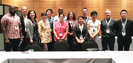
November 10, 2017
|
|
Participants in a town hall offered by the Population and Environment Research Network (PERN) October 31, 2017 at the International Population Conference (IPC) include Landy Sanchez (third from the left), chair of the PERN Steering Committee, and CIESIN research scientist Susana Adamo, co-coordinator of PERN (sixth from the right). |
Cape Town, South Africa, was the site of the 28th International Population Conference (IPC) of the International Union for the Scientific Study of Population (IUSSP), hosted October 29–November 4 by Statistics South Africa on behalf of the Republic of South Africa. CIESIN research scientist Susana Adamo and deputy director Marc Levy joined approximately 2,000 other population experts and practitioners at the conference, which is held every four years. At the University of Cape Town October 29, Adamo gave the lecture, “Mapping populations: Gridded Population of the World version 4 (GPW4),” for a pre-conference workshop on combining satellite, survey, census and cellphone data to provide small-area estimates. During the IPC, she presented the poster, ‟Urban Growth and Water Access in Least Developed Countries: Progress, Challenges, and Emerging Research Directions,” based on a 2015 cyberseminar offered by the Population Environment Research Network (PERN). She also co-authored the paper, ‟Assessing the Regional Context of Migration in Brazilian Legal Amazonia through Spatial Regression Modeling,” in a session on spatial methods in demography. Adamo served as a discussant in a session on population, consumption, and the environment and hosted a PERN “town hall″meeting for members attending the IPC. Levy also participated in the pre-conference workshop, reporting on a new project to build African geospatial capacity supported by the Bill & Melinda Gates Foundation and the United Kingdom's Department for International Development.
PERN is a scientific panel of IUSSP, established in 2001 and hosted by CIESIN, with support from the NASA Socioeconomic Data and Applications Center (SEDAC). The IUSSP is an individual membership association open to all scientists and professionals working in the field of population.
Remote Sensing and Population Data Highlighted in London, Dublin, and Dubai
November 8, 2017Greg Yetman, associate director for geospatial applications at CIESIN, highlighted a range of new geospatial data products on human settlements and population distribution at three recent meetings in London, England; Dublin, Ireland; and Dubai, United Arab Emirates (UAE). He first participated in the workshop, “Satellite Applications for Sustainable Development,” organized by Satellite Applications Catapult at the Royal Aeronautical Society in London October 30-31. There he highlighted the population, environmental, and infrastructure data available from the NASA Socioeconomic Data and Applications Center (SEDAC) operated by CIESIN, as well as ongoing population modeling research projects at CIESIN. The workshop convened researchers and professional staff from United Kingdom government agencies and universities, the World Bank, and several United Nations agencies to identify opportunities for using satellite data streams to help achieve the Sustainable Development Goals adopted by the international community in 2015.
In Dublin November 2–3, Yetman attended the 10th European Forum for Geography and Statistics (EFGS), where he presented a poster describing new population distribution estimates by age category and gender for the year 2010, soon to be released as part of the SEDAC Gridded Population of the World version 4 (GPWv4) data collection. Yetman also represented CIESIN at the Global Forum for Geography and Statistics council meeting held during the conference. GPW was featured in the opening session remarks by the president of the EFGS, and CIESIN’s contributions to the Global Human Settlement Layer population model (GHSL-POP) were also acknowledged during the Forum.
Yetman subsequently travelled to Dubai, where the United Nations Office of Outer Space Affairs (UNOOSA) and the UAE Space Agency jointly organized a High-Level Forum, “Space as Driver for Socio-Economic Sustainable Development,” November 6–9. He participated in a side meeting November 6–7 to discuss development of the Global Partnership for the Coordination of the Development, Operation and Utilization of Space related Infrastructure, Data, Information and Services in support of the 2030 Agenda for Sustainable Development.
Papers Published on African Climate Vulnerability and Water Access Issues
November 6, 2017Two journal articles by CIESIN scientists have been published recently focusing on climate vulnerability mapping and on urban growth and water access in Africa. Alex de Sherbinin, associate director for science applications, is lead author of a paper in The Geographical Journal, “Mapping the Future: Policy Applications of Climate Vulnerability Mapping in West Africa.” Co-authors are Alex Apotsos and Jeremy Chevrier of the United States Agency for International Development. The paper documents the development of climate vulnerability maps for three Sahelian countries―Mali, Burkina Faso, and Niger―and for coastal West Africa. It focuses on the way the maps were designed to meet decision-making needs and their ultimate influence and use in policy contexts.
The paper, “Urban Growth and Water Access in Sub-Saharan Africa: Progress, Challenges, and Emerging Research Directions,” appears in the journal, Science of the Total Environment. Lead author Stéphanie dos Santos of the Institut de Recherche pour le Développement, Laboratoire Population-Environnement-Développement (IRD/AMU) in Marseille, France, was an expert contributor to a Population-Environment Research Network (PERN) online seminar on water and population dynamics held in October 2015. Co-authors of the paper include de Sherbinin and CIESIN research scientist Susana Adamo, who are the co-coordinators of PERN. The paper reviews empirical knowledge of urban dynamics and water issues in sub-Saharan Africa and provides research recommendations.
Geographic information specialist Linda Pistolesi, Adamo, and senior research staff assistant Olena Borkovska have also published a short article in the “Data Points″ section of the Fall 2017 issue of PAA Affairs, the quarterly newsletter of the Population Association of America. The article describes mapping of the subnational total dependency ratio (TDR) using the forthcoming global age and sex structure grids from the Gridded Population of the World version 4 (GPWv4) data collection.
- “Mapping the Future: Policy Applications of Climate Vulnerability Mapping in West Africa”
- “Urban Growth and Water Access in Sub-Saharan Africa: Progress, Challenges, and Emerging Research Directions”
- “Mapping Subnational Total Dependency Ratio (TDR) with GPWv4 Global Age and Sex Structure Grids” (3.29 MB PDF)
Population Displacement Due to Disasters Discussed in Switzerland
November 3, 2017Susana Adamo and Alex de Sherbinin, CIESIN experts in environmental migration and displacement, attended a workshop of the Advisory Committee of the Platform on Disaster Displacement (PDD) October 23‒24 in Bogis-Bossey, Switzerland. Workshop participants assessed progress in implementing recommendations from the Advisory Committee's first meeting in 2016 and the PDD Workplan for 2016‒2019. Adamo and de Sherbinin participated in the PDD Data and Knowledge Working Group and in discussions on regional priorities for Africa and the Americas. Approximately 90 representatives from Advisory Committee organizations, including representatives from the United Nations Office of High Commissioner for Refugees (UNHCR) and the International Organization for Migration (IOM), attended the workshop.
Prior to the workshop, Adamo had attended an expert meeting on "Slow onset effects of climate change and human rights protection for cross-border migrants," organized by UNHCR October 5 in Geneva. She served as the opening discussant in a session on "Protection needs: Understanding the intersecting factors that cause or exacerbate vulnerability in the context of slow onset events."
Adamo, who is a research scientist at CIESIN, and de Sherbinin, who is associate director for science applications, were invited in 2016 by the Government of Germany to serve on the PDD Advisory Committee. The PDD continues the work of the Nansen Initiative, supporting implementation of the 2015 recommendations of the Nansen Initiative Agenda for the Protection of Cross-Border Displaced Persons in the Context of Disasters and Climate Change, known as the Protection Agenda. The Advisory Committee provides expert strategic input to the PDD's chair and steering group, and helps implement PDD activities. CIESIN, together with the Sabin Center for Climate Change Law at Columbia, are two of the Advisory Committee organizations. Based in Geneva, Switzerland, the PDD is supported by the governments of France, Germany, and Switzerland and the MacArthur Foundation.
Group on Earth Observations Showcases Progress in Washington DC
October 30, 2017
|
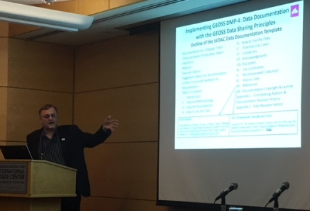
|
CIESIN senior digital archivist Robert Downs describes SEDAC's data documentation template at the October 23 side event, “Best Practices – Data Sharing and Data Management in GEO,” during GEO Week 2017 in Washington DC. |
The fourteenth Plenary of the Group on Earth Observations (GEO-XIV) was held October 25-26 in Washington DC, bringing together more than two hundred representatives of GEO Members and Participating Organizations. The Plenary was the centerpiece of “GEO Week 2017: Insight for a Changing World,” which included a variety of side events, working meetings, and a public exhibition at the Ronald Reagan Building and International Trade Center. CIESIN director Robert Chen and senior digital archivist Robert Downs represented the International Council for Science (ICSU) World Data System (WDS) at the Plenary, and also contributed to several side events and other activities. On October 23, Chen co-organized the side event, “Best Practices – Data Sharing and Data Management in GEO,” during which he moderated the opening panel on “Why Does Open Data Sharing and Sound Data Management Matter?” Downs highlighted activities of the NASA Socioeconomic Data and Applications Center (SEDAC) operated by CIESIN in an afternoon panel, “Best Practices in the GEOSS Common Infrastructure.” On October 24, Chen gave a short panel presentation on urban sustainability indicators at a morning side event on “Earth Observations in Service of the 2030 Agenda for Sustainable Development” (EO4SDG). He then co-moderated an afternoon side event on “Sustainable Development on Our Human Planet: The GEO Human Planet Initiative” and gave a talk on translating Earth observations data into actionable information for policy. Chen and Downs also participated in working meetings of the GEO Data Sharing Working Group and the EO4SDG initiative.
GEO is a voluntary intergovernmental partnership of more than 100 national governments and over 115 Participating Organizations that envisions a future where decisions and actions for the benefit of humankind are informed by coordinated, comprehensive and sustained Earth observations. SEDAC is a member of ICSU-WDS and has contributed to a variety of GEO activities and initiatives for more than a decade.
Thousands Attend Open House at Lamont to Enjoy, Explore, Learn
October 9, 2017
|
|
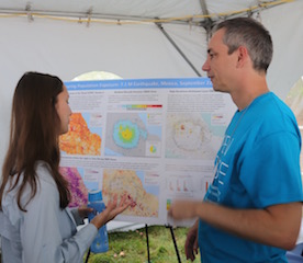
Columbia graduate student Christina Paton (left) discusses population exposure during the September 7.1-magnitude earthquake near Mexico City with geographic information specialist John Squires (right). |
More than 3,500 visitors from across the region came to the Lamont campus of Columbia University October 7 to "Enjoy, Explore, Learn" during the all-day Lamont-Doherty Open House in Palisades NY. The Open House provides the scientists and centers at Lamont with the opportunity to showcase their work, engage visitors in hands-on activities and demonstrations, and support informal learning about science by students and the general public. This year, CIESIN's booth featured interactive demonstrations of two hazard-related mapping tools: the HazPop mobile application for iPhone and iPad and the SEDAC Hazards Mapper, both developed through the NASA Socioeconomic Data and Applications Center (SEDAC). Visitors could also learn more about the populations affected by two recent natural disasters, Hurricane Harvey in Texas in August and the Mexico City earthquake in September. Two other interactive decision support tools were demonstrated, the Jamaica Bay Water Quality Data Visualization and Access Tool and AdaptMap, which focuses on adaptation to flooding and sea level rise in Jamaica Bay. CIESIN's international development work was represented by a poster on community and ecosystem vulnerability to climate change in the coastal areas of Sierra Leone, part of the West Africa Biodiversity and Climate Change (WA-BICC) project of the U.S. Agency for International Development. More than a dozen CIESIN staff members volunteered their time at the booth on a warm, fall weekend day.
World Data System Scientific Committee Meets in Kyoto
October 4, 2017Alex de Sherbinin, CIESIN associate director for science applications and SEDAC deputy manager, traveled to Kyoto, Japan for a meeting of the Scientific Committee of the International Council for Science World Data System (ICSU-WDS) held September 30-October 1. Key issues addressed at the meeting were the recent launch of the CoreTrustSeal certification, developed jointly by ICSU-WDS and the Data Seal of Approval, and updating of the ICSU-WDS strategic plan. At the meeting, de Sherbinin described ongoing work to encourage data centers involved in the NASA SERVIR West Africa hub to seek certification under the CoreTrustSeal and to join the WDS. He also reported on the work of the CODATA-WDS Task Group on Citizen Science Data, which he co-chairs.
The Scientific Committee is the governing body of the World Data System, which is an interdisciplinary body of the International Council for Science established in 2008. SEDAC is a regular member of the WDS, and the NASA Earth Science Data and Information System (ESDIS) Project is a WDS network member. Dr. de Sherbinin has been a member of the Scientific Committee since 2015. The meeting was hosted by Japan's National Institute of Information and Communications Technology (NICT).
New Database Facilitates Analysis of Use of Interdisciplinary Data
September 29, 2017Understanding how scientific data have been used in scientific studies is important to further use of the data in both science and in practical applications. The NASA Socioeconomic Data and Applications Center (SEDAC) has tracked the use of its data for more than two decades in a range of scientific publications, in order to better see how these data are incorporated into scientific research and combined with remote sensing and other types of data. Such scientific citations are also useful for SEDAC's data users, who may wish to see how others have used the data, and what opportunities and limitations have been found.
With this in mind, SEDAC has recently released a searchable database of scientific citations, containing more than 3,400 citations of SEDAC data published since 1995. This database enables users to more easily find and access relevant citations, especially those that also cite remote sensing data in conjunction with SEDAC data. Users may filter and sort citations in various ways, and export them to a file. Digital Object Identifiers (DOIs) or other direct links to the publications are provided whenever possible. Access to the full text of the publications may require a subscription. The database provides direct links to relevant citations from the "landing pages" for data sets within SEDAC's web site.
Tenth Research Data Alliance Plenary Held in Montreal
September 25, 2017"Better Data, Better Decisions" was the theme of the Tenth Plenary (P10) of the Research Data Alliance (RDA) held September 19-21 in Montreal, Canada. P10 drew a range of data scientists, managers, librarians, sponsors, and government agency representatives to Montreal, many of whom participated in several co-located events during the week. Robert Downs, CIESIN senior digital archivist, participated in the side event, "Research Data for Better Public Decisions" and in the RDA Technical Advisory Board and Working Group/Interest Group Chairs meeting September 18. During P10, he gave two presentations, "Improving a Trustworthy Data Repository with ISO 16363," and "Repository Platforms for Research Data: Addressing Requirements and Gaps." He also presented a poster on "Disseminating Open Source Software with Open Data: A Case Study from a Scientific Data Center," co-authored with senior research associate Pinki Mondal. Downs chaired a session organized by the Repository Platforms for Research Data Interest Group and served as a rapporteur during sessions of the RDA/CODATA Legal Interoperability Interest Group, which is co-chaired by CIESIN director Robert Chen. After P10, Downs represented the Group on Earth Observations (GEO) in a September 21 meeting of the Belmont Forum e-Infrastructures and Data Management Oversight Committee.
Spatial Data, Sustainable Development, and Climate Migration Addressed in New York City Talks
September 21, 2017Alex de Sherbinin, CIESIN associate director for the science applications, gave a talk on “Spatial Data for the 2030 Agenda on Sustainable Development" at a learning session on “Navigating the Data Revolution" at Columbia University September 19. Organized by the United Nations Sustainable Development Solutions Network (UNSDSN) and the Group on Earth Observations (GEO), the session drew approximately 40 participants attending the International Conference on Sustainable Development (ICSD) at Columbia. Later that day, de Sherbinin gave a keynote speech on climate change-induced displacement and resettlement at the event, "Human Impact: A Gathering about Climate Migration." The event was organized by Domini Impact Investments as part of Climate Week NYC, September 18-24.
Forum Highlights New Ways to Assess Human Settlement Patterns and Change
September 18, 2017The University of Twente in Enschede, the Netherlands, hosted more than 90 experts on population distribution and change, urbanization, remote sensing, and related fields for the first Human Planet Forum, organized September 13-15 by the Human Planet initiative (HPI) of the Group on Earth Observations (GEO). The Forum sought to highlight recent progress since last year's HPI launch as part of GEO's 2017-2019 work programme, to expand participation and partnerships in the initiative, and refine plans for collaborative work. CIESIN director Robert Chen participated in the Forum's opening session, giving a welcome on behalf of William Sonntag of the GEO Secretariat, whose arrival was delayed by poor weather. Chen also served as a session moderator and gave a presentation on a new project on human settlement, infrastructure, and population data, recently funded by the Bill & Melinda Gates Foundation, aimed at better coordinating and documenting the growing number of global data products on population distribution and related settlement characteristics. Deputy director Marc Levy and Geographic Information Systems programmer Kytt MacManus also attended the Forum, participating in planning discussions for several HPI activities and related projects. The Forum was organized jointly by GEO, the European Commission (EC) Joint Research Centre (JRC), and the University of Twente's Faculty of Geo-Information Science and Earth Observation (ITC).
Strengthening Disaster Risk Reduction Addressed in Buenos Aires Summit
September 12, 2017Representatives of government agencies, United Nations bodies, the Red Cross and Red Crescent Societies, other nongovernmental organizations and civil society groups, businesses, and scientific institutions gathered in Buenos Aires, Argentina September 3-8 for a Regional Summit on Strengthening Disaster Risk Reduction across the Americas. The Summit focused on how Earth Observations (EO) can help reduce the risks of disasters to society through open exchange and dissemination of EO data and improved end-to-end flow of data and information from providers to practitioners and decision makers. Research scientist Susana Adamo participated in the Summit as a representative of the Earth Science Information Partners (ESIP), giving an oral presentation on "ESIP strategies on data driven decision making in disaster risk reduction." She also presented a poster on ESIP initiatives in disaster lifecycle management and helped to organize and evaluate a simulation exercise, held during the Summit in both Spanish and English, for a fictional disaster scenario.
The Summit was hosted by Argentina's space agency, the National Commission for Space Activities (CONAE), and organized by the NASA Disasters Program in collaboration with the Group on Earth Observations (GEO), the Committee on Earth Observation Satellites (CEOS), the Global Flood Partnership (GFP), and the Open Geospatial Consortium (OGC). The NASA Socioeconomic Data and Applications Center (SEDAC) operated by CIESIN is a Type 2 ESIP member, and is an active contributor to the ESIP Disaster Lifecycle Cluster.
CIESIN Scientists Active in Two Workshops in Accra, Ghana
September 11, 2017
|
|
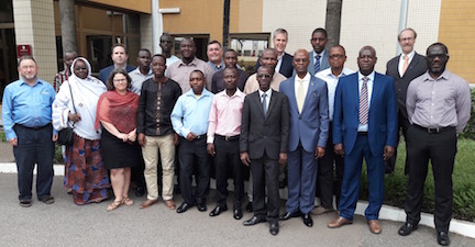
Participants in the Geospatial Data Training Workshop at the Accra City Hotel in Accra, Ghana, September 6-8, organized by the West Africa hub of SERVIR. |
More than 20 data experts and managers met in Accra, Ghana September 6-8 to participate in a training workshop on geospatial data management, policy, and use, organized in support of the West Africa hub of SERVIR, a joint development initiative of the National Aeronautics and Space Administration (NASA) and the United States Agency for International Development (USAID). Greg Yetman, associate director for geospatial applications, and Alex de Sherbinin, associate director for science applications, co-led the workshop, together with John Del Corral of the International Research Institute for Climate and Society (IRI). The workshop addressed the importance of standards, open data, and sound data management practices, and included hands-on exercises in metadata development and use of IRI's climate data library. Sessions were also held on the architecture for the new SERVIR West Africa hub data portal and the development of data sharing agreements between members of the SERVIR consortium. Consortium members include the Regional Center of Agro-Meteorology (AGRHYMET), the Center for Ecological Monitoring (CSE) of Senegal, the African Center for Meteorology Applied to Development (ACMAD), the Centre for Remote Sensing and Geographic Information Systems (CERSGIS) of Ghana, the African Regional Institute for Geospatial Information Science and Technology (AfriGIST), and International Crops Research Institute for the Semi-Arid Tropics (ICRISAT). CIESIN is part of a team led by Tetra Tech, Inc. that is supporting development of the West Africa hub, which aims to help stakeholders and decision makers make more informed decisions related to agriculture and food security, water resources and hydroclimatic disasters, weather and climate, and land cover and land use change and ecosystems.
In parallel with the SERVIR workshop, climate scientist Sylwia Trzaska, together with de Sherbinin, participated in the West Africa Biodiversity and Climate Change (WA BiCC) project's annual work plan validation workshop September 6-7. The two-day workshop involved project staff and representatives of regional partners, including the Economic Community of West African States (ECOWAS), the Abidjan Convention for Co-Operation in the Protection and Development of the Marine and Coastal environment of the West and Central African Region, and the Manor River Union, as well as representatives of USAID. Workshop participants reviewed progress to date and activities proposed for the next year. Trzaska briefly presented the results of a vulnerability assessment carried out by CIESIN in the mangrove areas of Sierra Leone last year. CIESIN is also a partner with Tetra Tech in supporting the USAID-funded WA BiCC project.
Climate Change and Population Dynamics Examined at Alpach Forum Seminar
August 22, 2017Alex de Sherbinin, associate director for science applications, co-chaired a six-day seminar on climate change and population dynamics at the European Forum Alpbach in Alpach, Austria, August 17-22. Together with fellow chair Dr. Raya Muttarak of the University of East Anglia and the International Institute for Applied Systems Analysis (IIASA), de Sherbinin lectured daily to more than 60 participants on topics including climate change science, vulnerability mapping, climate change-induced migration, and demographic aspects of climate mitigation. The Alpbach Forum has been convened each year since 1946 in Alpbach as an effort to broaden the education and offer new perspectives to students in post-World War II Europe. The Forum now has 700 students, selected from an applicant pool of 3,500, from all over the world, at different stages in their academic careers, and from many disciplines. The Seminar Week is the academic centerpiece of the Forum, with 18 interdisciplinary seminars conceptualised and facilitated by internationally-renowned academics.
Open Geospatial Community Gathers in Boston
August 18, 2017Boston Harbor was the backdrop for more than 1,000 geospatial software developers, users, and other experts attending the International Conference for Free and Open Source Software for Geospatial (FOSS4G) August 14-19. Kytt MacManus, geospatial information system programmer, gave a talk on "Open Data and Processing Services at NASA's Socioeconomic Data and Applications Center (SEDAC)," providing an overview of SEDAC's many free and open mapping tools and data services. FOSS4G is the largest global gathering focused on open source geospatial software and associated products, standards, and protocols.
Experts on Geographic Names Hold 11th Conference in New York
August 17, 2017The United Nations Group of Experts on Geographical Names (UNGEGN) held the 11th United Nations Conference on the Standardisation of Geographical Names at UN Headquarters in New York on August 8-17. The Conference, which marked the 50th anniversary of the UNGEGN, serves as a forum to encourage national and international geographical names standardization, promote international dissemination of nationally standardized geographical names information, and adopt single romanization systems for converting non-Roman writing systems to the Roman alphabet. On August 15, Greg Yetman, CIESIN associate director for geospatial applications, gave a special presentation on “Detailed Population Modeling: The Integration of Satellite and Census Data,” highlighting work by CIESIN and other groups around the world on population and settlement mapping. A video of his presentation and subsequent discussion is available through UN WebTV.
Ecology from Space Demonstrated at Portland, Oregon Workshop
August 11, 2017
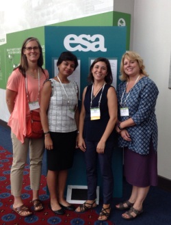
|
|
Presenters at the Ecology from Space workshop at the Ecological Society of America annual meeting, Portland, Oregon, August 10. Left to right: Michele Thornton, ORNL; Pinki Mondal, SEDAC; Alison Boyer, ORNL; Jennifer Brennan, ESDIS. Not pictured: Cole Krehbiel, LP-DAAC. |
Scientists from three NASA Distributed Active Archive Centers (DAACs) joined together at the Ecological Society of America annual meeting in Portland, Oregon to give a workshop on "Ecology from Space: How Can NASA Remote-Sensing Data Inform Your Research?" August 10. CIESIN senior research associate Pinki Mondal gave a presentation and demonstration about data and applications from the NASA Socioeconomic Data and Applications Center (SEDAC) operated by CIESIN, highlighting geospatial data sets from SEDAC relevant to ecological research. The workshop was organized by Alison G. Boyer of the Oak Ridge National Laboratory (ORNL) DAAC, with presentations from ORNL scientist Michele M. Thornton, Cole Krehbiel from the Land Processes (LP) DAAC, and Jennifer Brennan from NASA's Earth Science Data and Information System (ESDIS) project. The aim of this workshop was to provide a beginner's level introduction to NASA's remote-sensing and ground-based ecological data and to demonstrate user friendly tools to access, subset, and visualize these data.
| 11 of 36 |