At the Sustainable Development Learning Event of the United Nations High-level Political Forum on Sustainable Development June 29 at UN Headquarters in New York City, Alex de Sherbinin, CIESIN associate director for science applications, gave two presentations. The first presentation provided an overview of the concepts of vulnerability, risk, and resilience and approaches to mapping these concepts. The second presentation focused on remote sensing and other novel data streams that can be applied to vulnerability mapping, as well as to index construction and issues of uncertainty. Held under the auspices of ECOSOC, this year's forum addressed the theme, strengthening integration, implementation, and review.
Resources »  News
News
| 21 of 36 |
CIESIN Associate Director Joins World Data System’s Scientific Committee
June 30, 2015Alex de Sherbinin, associate director for science applications at CIESIN, has been appointed to the Scientific Committee (SC) of the International Council for Science (ICSU) World Data System (WDS) for a three-year term beginning July 1. The SC is the governing body of the WDS, responsible for developing and prioritizing WDS plans, guiding their implementation, and publicizing the results. SC members are leading scientists and experts actively involved with data management and stewardship who have been selected by the ICSU Executive Board after an open nomination process. The new chair of the SC is Sandy Harrison of the University of Reading in the United Kingdom and Macquarie University in Australia.
The NASA Socioeconomic Data and Applications Center (SEDAC) operated by CIESIN recently became a WDS regular member, joining most of the other NASA data centers as well as the NASA Earth Science Data and Information System (ESDIS) Project. CIESIN director Robert Chen is SEDAC’s manager and de Sherbinin serves as its deputy manager. The WDS currently has more than 90 member organizations in four different categories.
Summer Institute Focuses on Integrating Spatial Frameworks Across Disciplines
June 29, 2015Bar Harbor, Maine, was the site of a week-long summer institute June 21-27, “Spatial Ontologies for e-Science,” sponsored by the Vespucci Initiative for the advancement of geographic information in science. GIS programmer Kytt MacManus was one of about fifteen participants in this interactive learning experience, which focused on how location often acts as an integrator in science, bringing together perspectives across multiple disciplines and scales. During the Institute, he presented a lightning talk on the potential for semantic Web technologies to enable the integration of population data sets in support of decision making. Facilitators this year included Peter Fox of Rensselaer Polytechnic Institute, Michael Grueninger of the University of Toronto, and Werner Kuhn of the University of Münster, Germany.
New Project to Assess Hazard Exposure in Five African Countries
June 24, 2015CIESIN is part of a team led by ImageCat, Inc that recently won a contract from the Global Facility for Disaster Reduction and Recovery (GFDRR), a global partnership managed by the World Bank, to develop a physical exposure database for five countries in Africa: Ethiopia, Kenya, Niger, Senegal, and Uganda. Key project tasks include development of spatial data on structural and infrastructural assets and estimates of their replacement costs; projection of the spatial distribution of population and Gross Domestic Product in the year 2050 consistent with socioeconomic scenario data currently under development by the research and assessment community; and collaboration with four other teams to support the integration of the exposure data with assessments of earthquake, flood, drought, and landslide hazards. Other project partners are Keith Porter from the University of Colorado Boulder, SecondMuse, and the Regional Centre for Mapping of Resources for Development (RCMRD) in Nairobi. CIESIN continues to work with ImageCat on a three-year award from the NASA Applied Sciences Program to develop and test methods of assessing global building exposure for disaster forecasting, mitigation, and response, using remote sensing data. ImageCat is an international risk management innovation company with offices in Long Beach, California and London.
Award Announced for Exceptional Data Stewardship
June 23, 2015The World Data System (WDS) of the International Council for Science (ICSU) has announced the 2015 Data Stewardship Award, aimed at recognizing exceptional contributions to the improvement of scientific data stewardship by early career researchers. Nominations may be submitted by representatives of ICSU WDS members and working groups, ICSU interdisciplinary bodies, and ICSU national and union members by Monday, September 7 (see form below). The award includes recognition at and travel to the plenary of the next Scientific Data Conference (SciDataCon), tentatively scheduled for fall 2016, as well as a state-of-the-art electronic tablet device. Nominees must be under age 40 and within ten years of the award of their PhD or equivalent professional training. Prior winners include Robert Redmon of the World Data Service for Geophysics and Xiaogang Ma from Rensselaer Polytechnic Institute.
Rescue of Millennium Ecosystem Assessment Data Completed
June 19, 2015
|
From 2001 to 2005, the Millennium Ecosystem Assessment (MA) brought together more than 1,300 experts worldwide to assess the consequences of ecosystem change for human well-being. The MA provided a comprehensive scientific appraisal of the condition and trends in the world’s ecosystems and associated services at that time, and articulated the scientific basis for action to conserve and use these ecosystems sustainably. The core data used and developed by the MA had been maintained by the U.S. Geological Survey’s National Biological Information Infrastructure (NBII) program, but unfortunately when this program was terminated in January 2012, access to the data ended.
To remedy this situation and to ensure long-term preservation of and access to these important data, the NASA Socioeconomic Data and Applications Center (SEDAC) operated by CIESIN obtained copies of the original data and has recently released them as the Millennium Ecosystem Assessment Collection. The original data consisted of many files that were not well documented or organized, so SEDAC has grouped the data into six separate data sets: population; scenarios; biodiversity; climate and land cover; ecosystems; and rapid land cover change. Although most of the data in the collection have been superseded by newer versions, the data may still be of interest from both scientific and historical perspectives since they reflect the state of knowledge at the time the assessment was completed.
In preparing the collection, SEDAC has sought to provide access to the data in their original formats with basic documentation. Users will need to refer directly to the MA reports for details on sources, methods, and interpretation of the data.
Climate Conference Side Event to Focus on Trusted Data Services
June 16, 2015In recognition of the importance of open sharing of quality-assured scientific data to climate research and policy, a side event, “Trusted Data Services to Support Climate Change Research,″ is planned in conjunction with the upcoming international conference, Our Common Future Under Climate Change, July 7–10 in Paris. The event, organized by the International Council for Science (ICSU) World Data System (WDS) in collaboration with the Group on Earth Observations (GEO), ICSU Committee on Data for Science and Technology (CODATA), Research Data Alliance (RDA), and the Organization for Economic Co-Operation and Development (OECD), has been granted a “COP21 label,″ highlighting its relevance to the 21st Session of the Conference of the Parties to the United Nations Framework Convention on Climate Change (COP21/CMP11), to be held in Paris in late 2015. During the July 6 event CIESIN director Robert Chen, in his capacity as manager of the NASA Socioeconomic Data and Applications Center (SEDAC), will give a short talk on integrating environmental and socioeconomic data to support interdisciplinary research and applications. He will also present, “Developing Indicators to Support Climate Adaptation and Sustainability Decision Making,″ co-authored with Alex de Sherbinin and Marc Levy, in a parallel session, “Quality and Availability of Data for Global Sustainability″ to be held day two of the conference. The side event, together with a second side event organized by ICSU, “Science and the Road to Transformation: Opportunities in the post-2015 Global Climate Regime,″ is expected to support the development of science community inputs into COP21.
Developing Usable Climate-Security Data Addressed in Boulder Symposium
June 8, 2015A symposium on climate and human security was organized by the World-Wide Human Geography Data (WWHGD) Working Group June 3–4 at the University of Colorado, Boulder. CIESIN deputy director Marc Levy was part of a panel, “Anticipating Near-term Climate Disruptions on the Human Geography Scales.” In his presentation, “In Search of Usable Climate-Security Data,” he argued that the task of generating effective climate-security data requires as much attention to deepening social ties across the climate-security communities as it does attention to technical data work. The WWHGD working group was created to focus on the need for human geography global foundation data in order to provide a basis for a deeper understanding of cultures, activities, and attitudes.
Map Enthusiasts Assess State of Open Mapping
June 6, 2015CIESIN staff joined OpenStreetMap (OSM) mapping enthusiasts at the annual State of the Map US 2015 conference in New York City June 6–7. Alex de Sherbinin, associate director for science applications, and Paola Kim-Blanco, senior research associate, presented a lightning talk, “Validation and Assimilation of OSM Data for the Global Roads Open Access Data Set.” With geographic information specialist Linda Pistolesi, they also organized a breakout group on validation and assimilation of OSM roads data. Geographic information specialist Dara Mendeloff also participated in the conference. OSM has had impressive growth in coverage and detail in the past decade, and is increasingly being seen as an authoritative data source. However, OSM still lags in some developing regions, and efforts to rectify this situation are being made through groups such as Missing Maps and Map Give. CIESIN's efforts, under the CODATA Global Roads Data Development Task Group with support from the NASA Socioeconomic Data and Applications Center (SEDAC), represent an important joint effort with OSM to evaluate the geometry, coverage, and completeness of the OSM roads data in the world′s poorest regions.
Social Science Data Experts Meet in Minneapolis
June 5, 2015CIESIN geospatial specialist Erin Doxsey-Whitfield and senior digital archivist Robert Downs were among the social science data managers, data librarians, and other experts participating in the 41st annual conference of the International Association for Social Science Information Services and Technology (IASSIST) June 2-5 in Minneapolis. On June 3, Downs presented, “Bridging Disciplines: Assessing the Interdisciplinary Impact of Open Data,” co-authored with Robert Chen, director of CIESIN. While in Minneapolis, Doxey-Whitfield visited the Minnesota Population Center (MPC) at the University of Minnesota to work on the Terra Populus project. MPC was a host of the conference, of which CIESIN was a gold sponsor.
See:
Urbanization Workshop Examines User Needs for Spatial Data and Tools
June 1, 2015A workshop sponsored by the European Commission (EC) Joint Research Centre May 27–29 in Ispra, Italy, convened more than 50 experts and planners from European and other international agency and academic organizations to discuss how new mapping tools and data can inform the design of spatial planning and promote best practices across the urban/rural spectrum. Greg Yetman, CIESIN associate director for geospatial applications, gave a presentation on the evolution of the Gridded Population of the World (GPW) data collection available from the NASA Socioeconomic Data and Applications Center (SEDAC). The newest version of GPW, due to be released later this year, integrates data from more than 14 million census units to create global surfaces of population counts and other variables at five-year intervals between 2000 and 2020, including estimated age and sex distributions.
Regional Environmental Issues Addressed in Western Hemisphere Meetings
May 29, 2015CIESIN scientists recently participated in several meetings focused on regional environmental issues in the Western Hemisphere. Deputy director Marc Levy co-chaired both the North America Regional Environmental Information Network (REIN) Conference May 27-28 and the first Global Environmental Outlook (GEO) Regional Authors' Meeting May 29 in Gatineau, Quebec. The two gatherings kicked off the North American Regional Assessment of the 6th Global Environmental Outlook (GEO-6), carried out under the auspices of the United Nations Environment Programme (UNEP). During the REIN Conference, government officials from the United States and Canada, along with scientific experts, agreed on priority environmental issues to inform the regional assessment. At the Authors′ Meeting, participants considered key themes to explore in the regional assessment, the structure of the report, and assignment of roles. Levy and Robert W. Correll are co-chairing the regional assessment, which is scheduled for release in spring 2016.
The annual meeting of the Scientific Advisory Committee (SAC) of the Inter-American Institute for Global Change Research (IAI) was held May 20–22 in Quito, Equador. CIESIN associate research scientist Susana Adamo gave a presentation on recent scientific developments in demography and population-environment studies relevant to the IAI’s collaborative resource networks and small grant programs. The SAC meeting included discussions with the Minister of the Environment and local university representatives on biodiversity issues. IAI is an intergovernmental organization supported by 19 countries in the Americas, whose mission is to increase understanding of global changes and their socioeconomic implications. The SAC agreed to hold its next meeting in spring 2016 in New York City.
Assessing Urban Climate Risk and Resilience
May 25, 2015Urban climate resilience—in particular, the case of New York City in the post-Superstorm Sandy period—was the subject of a presentation by Alex de Sherbinin, CIESIN associate director for science applications, to a delegation from Électricité de France (EDF) on May 22 at the School for International and Public Affairs, Columbia University. His presentation reviewed major urban risks associated with climate change, including heat stress, flooding, and sea level rise, and highlighted a range of resilience and adaptation strategies being undertaken in New York City. The delegation included recipients of EDF Pulse Awards, which support innovation in the energy sector.
User Working Group Reviews SEDAC Progress
May 23, 2015The User Working Group (UWG) of the NASA Socioeconomic Data and Applications Center (SEDAC) operated by CIESIN met May 18–19 to review SEDAC activities and plans and to provide guidance on strategic directions and user needs. Key discussion topics included SEDAC′s evolving role in addressing data needs stemming from international negotiations regarding the Sustainable Development Goals (SDGs) and the potential value of developing “virtual collections” of remote sensing and socioeconomic data in collaboration with other NASA data centers. The meeting included a presentation on the NASA Soil Moisture Active Passive (SMAP) mission by outgoing UWG member Kyle McDonald of the City University of New York (CUNY), who also hosted the second day of the meeting at the CUNY Advanced Science Research Center in Manhattan. Daniel Bader of the NASA Goddard Institute for Space Studies (GISS) and the Columbia University Center for Climate Systems Research (CCSR) also presented on New York City′s resilience to climate change. The UWG meeting was chaired by Myron Gutmann of the University of Colorado and included representatives from NASA headquarters and the NASA Goddard Space Flight Center.
Experts Consider Improvements in Scenarios Used in International Climate Assessments
May 22, 2015CIESIN deputy director Marc Levy participated in the Intergovernmental Panel on Climate Change (IPCC) Expert Meeting on Scenarios, which took place May 18–20 at the International Institute for Applied Systems Analysis (IIASA) in Laxenburg, Austria. Participants took stock of the use of climate and socioeconomic scenarios in the IPCC Fifth Assessment Report and recommended actions to improve their use in the Sixth Assessment. Levy gave a presentation on the second day of the meeting, proposing how governance indicators could be incorporated into climate scenarios. He also participated in a working group meeting May 21 on quantitative impacts, adaptation, and vulnerability indicators, organized by the International Committee on New Integrated Climate Change Scenarios (ICONICS). The meeting reviewed recent work on quantitative scenarios of poverty rates and income distribution.
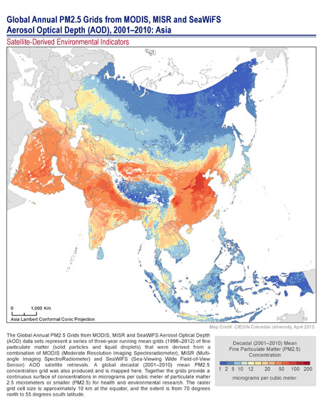
Satellite Data Provide Insights into Long-Term Air Quality Trends
May 15, 2015
|
A new data release offers insights into the extent of global human exposure to fine particulate matter (PM2.5) over more than a decade. The new data set replaces an earlier one released by the NASA Socioeconomic Data and Applications Center operated by CIESIN and features improved accuracy, a longer time span, and higher spatial resolution than the previous version.
Satellite-derived estimates of PM2.5 provide one of the few ways of assessing changes in exposure to air pollution around the world over the long term. The data set consists of a series of global grids representing three-year running averages, from 1998-2012, derived from measurements of Aerosol Optical Depth (AOD) from three different NASA instruments: MODIS (Moderate Resolution Imaging Spectroradiometer), MISR (Multi-angle Imaging SpectroRadiometer), and SeaWIFS (Sea-Viewing Wide Field-of-View Sensor). The grids were developed by Aaron van Donkelaar and colleagues at Dalhousie University in Canada.
These global grids of estimated PM2.5 surface concentrations, expressed in micrograms per cubic meter (μg/m3), are useful for health and environmental research and have already served as a valuable input to the World Health Organization (WHO) global burden of disease study. Fine-particulate matter represents one of the most serious types of air pollutants and is of particular concern in many parts of Asia. For example, the estimated proportion of the people in East Asia living above the WHO Interim Target-1 of 35 μg/m3 increased from 51% in 1998–2000 to 70% in 2010–2012.
The raster grids have a grid cell resolution of 6 arc-minutes (0.1 degree, or approximately 10 km at the equator) and cover the global land surface from 70 degrees north to 55 degrees south. More details can be found in the van Donkelaar et al. 2015 article, “Use of Satellite Observations for Long-Term Exposure Assessment of Global Concentrations of Fine Particulate Matter,” in the journal Environmental Health Perspectives.
Monitoring Gap Will Increase for the Sustainable Development Goals
May 15, 2015In a recent visit to the Oak Ridge National Laboratory (ORNL) of the U.S. Department of Energy (DOE) in Oak Ridge, Tennessee, CIESIN deputy director Marc Levy gave a presentation to the ORNL Environmental Sciences Division on data and monitoring needs for the new Sustainable Development Goals (SDGs). The SDGs are currently under negotiation by governments as part of the post-2015 development agenda; after they have been adopted, the international community will face an even larger gap between monitoring needs and available capabilities. A global data partnership and an expert consultation are needed.
While at ORNL, Levy participated as an observer in a meeting of the user working group (UWG) of the ORNL Distributed Active Archive Center (ORNL DAAC) May 13–14, in his capacity as the lead project scientist for the NASA Socioeconomic Data and Applications Center (SEDAC) operated by CIESIN. Like SEDAC, the ORNL DAAC is part of NASA Earth Observing System Data and Information System (EOSDIS); its focus is on biogeochemical and ecological data and models.
Earth Observation Strategy and Work Program Developed in Geneva
May 8, 2015More than 100 representatives of member states and participating organizations of the Group on Earth Observations (GEO) met May 4–7 in Geneva, Switzerland, to discuss and further develop a new strategy and work program for the next phase of the voluntary intergovernmental organization. CIESIN director Robert Chen participated in the meeting in his capacity as a co-chair of the GEO Data Sharing Working Group, which oversees the evolution and implementation of the data sharing principles for the Global Earth Observing System of Systems (GEOSS). Established in 2005, GEO has successfully implemented GEOSS as an operational network that links remote sensing and other geospatial data from around the world and makes them accessible for both research and decision making. Over the next decade, GEO plans to incorporate rapidly growing volumes of data from increasingly diverse sources and ensure their regular use in many different public and private sector applications. The NASA Socioeconomic Data and Applications Center (SEDAC) operated by CIESIN is a unique element of GEOSS, providing key socioeconomic data and services that facilitate such real-world applications. SEDAC is currently contributing to phase 8 of the Architecture Implementation Pilot (AIP-8), which is testing new apps and tools for energy and disaster management applications.
Climate-Violence Links Explored in Recent Talk
May 7, 2015Links between climate stress and political violence were the subject of a talk by CIESIN deputy director Marc Levy at an interdisciplinary workshop organized by the Initiative on Extreme Weather and Climate May 6 at Columbia University′s Morningside campus in New York City. Levy was one of 15 speakers from Columbia on topics such as hurricanes and droughts, disease transmission, and energy resilience. His presentation, “Extremes and Extremism: Why Climate Stress Increases Political Violence,” looked at how climate stress can trigger political instability and violence across linked systems and how efforts to manage risk may lead to more instability. He also discussed why some people persist in denying climate-security connections. A video of a longer version of the lecture, given at Simon Fraser University in Vancouver earlier this year, is now available online.
CIESIN Deputy Director to Co-Lead North American Environmental Assessment
May 1, 2015Marc Levy, CIESIN deputy director, has agreed to serve as one of two co-chairs of the North American Regional Assessment for the sixth Global Environment Outlook (GEO-6) being developed by the United Nations Environmental Programme (UNEP). GEO-6 will use a regional assessment approach to create a comprehensive picture of the environmental factors contributing to human well-being and to analyze policy options for achieving environmental objectives and goals. Together with co-chair Robert Corell, Levy will help coordinate the work of more than 40 experts on the North American assessment.
| 21 of 36 |