Each year, NASA commissions an online satisfaction survey of users of its Earth Observing System Data and Information System (EOSDIS) data, tools, and support. Registered users of the Socioeconomic Data and Applications Center (SEDAC) operated by CIESIN, which is one of the EOSDIS data centers, should receive an e-mail invitation from the CFI Group requesting feedback on SEDAC data products and services. This year’s survey is shorter than previous surveys, but now has some optional questions for SEDAC users. For further information on the survey, please contact SEDAC User Services.
Resources »  News
News
| 20 of 36 |
Environmental Geographer Joins Science Applications Division
September 11, 2015

|
Environmental geographer Pinki Mondal has joined CIESIN’s Science Applications Division as a senior research associate, where she will be contributing to a number of CIESIN projects and activities and continuing her work with collaborators from Columbia and New York University. Previously a postdoctoral research scientist in the DeFries Lab at Columbia's Department of Ecology, Evolution & Environmental Biology, Mondal has a PhD in land change science from the University of Florida. She is currently co-editing, with Harini Nagendra and Ruth DeFries, a Special Section, “Livelihood impacts and adaptation of rural communities to climate change in India,” to be published in Current Science. This fall she is also teaching a course on physical geography at the City University of New York (City College campus). Earlier this year, Mondal collaborated with CIESIN on the development of satellite-derived environmental indicators related to land-surface temperature and urban heat islands, to be released by the NASA Socieconomic Data and Applications Center (SEDAC).
SEDAC Hazards Mapper Estimates Population Near Hazards and Infrastructure
September 10, 2015
|
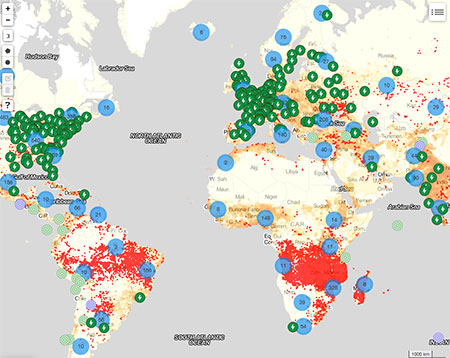
A new online mapping tool, the SEDAC Hazards Mapper, enables users to easily display recent natural hazard data in relationship to population, human settlements, major infrastructure, and satellite imagery. Hazards data include the location of active fires over the past 48 hours; earthquake alerts over the past seven days; flood and tornado warnings in the U.S. in near real-time; and yesterday′s air pollution data measured from space. The mapper shows the location of major dams and nuclear power plants and provides more detailed information and imagery for these facilities where available. By drawing a circle or polygon around a point or area of interest on the map, users can obtain an estimate of the total population and land area enclosed within.
Developed by the NASA Socioeconomic Data and Applications Center operated by CIESIN, the SEDAC Hazards Mapper combines layers from various sources including NASA's Land, Atmosphere Near real-time Capability for EOS (LANCE) and Global Imagery Browse Services (GIBS), the U.S. Geological Survey (USGS), the National Oceanic and Atmospheric Administration (NOAA), Esri, and others, using a variety of open Web mapping services. The population and settlement data are based on SEDAC′s Gridded Population of the World, version 3 (GPWv3) data for 2005 and the Global Rural Urban Mapping Project (GRUMP) data collection. The custom population estimates are provided by the SEDAC Population Estimation Service (PES). SEDAC plans to add more hazard and infrastructure layers and update the population data in early 2016.
The mapper is designed to be used by disaster risk managers, humanitarian response organizations, public health professionals, journalists, and others needing a quick assessment of the potential dangers posed by a major hazardous event or developing emergency. For example, a disaster response agency can obtain a rough estimate of the population and major facilities near a recent earthquake or a predicted flood as an input into response planning. Journalists or students can explore the location of recent wildfires relative to human settlements, dense populations, roads, terrain, and water bodies. Due to the coarse resolution and varying quality of some of the data, the mapper is not intended to support in-depth risk assessment or location-specific response needs.
See:
Scholars from India and Romania Arrive at CIESIN
September 4, 2015A Fulbright-Nehru postdoctoral fellow from India and a visiting staff associate from Romania have begun appointments at CIESIN. Saleem Khan is spending one year at CIESIN to conduct research on communicating the risks of sea level rise and engaging urban stakeholders in framing community-based adaptation strategies, working with associate director for Science Applications Alex de Sherbinin and director Robert Chen. Khan received his PhD in climate change sciences from the Centre for Climate Change and Adaptation Research, Anna University, in Chennai, India. In 2013 he was selected as a Next Generation Climate Change Scholar, part of an initiative by the National Science Foundation and NASA to acknowledge the critical value of interdisciplinary and communications skills in climate change research.
Bogdan-Mihai Cîrlugea is working with de Sherbinin until mid-February next year, assessing the accuracy of OpenStreetMap road data for integration into the Global Roads Open Access Data Set (gROADS) as the basis for his master’s thesis. He has a bachelor’s of engineering from Polytechnic University of Timisoara in Romania and is currently getting his master’s in environmental engineering, with a specialization in environmental modeling and monitoring, at École Polytechnique Fédérale de Lausannne (EPFL) in Switzerland. Cîrlugea recently completed an internship for CSD Engineers in Lausanne, a leading engineering consulting enterprise in Switzerland, where he provided geographic information systems support to projects ranging from noise pollution assessment and mitigation projects to territorial energy planning.
Demographer Deborah Balk Profiled in NASA Series
September 3, 2015Former CIESIN research scientist Deborah Balk has been featured in the NASA Earthdata User Profile series. Balk, a professor at Baruch School of Public Affairs, City University of New York (CUNY) Graduate Center Doctoral Programs in Public Health, Sociology, and Economics, is also associate director of the CUNY Institute of Demographic Research. She studies urbanization in the developing world, using a spatial framework to explore the demographic implications of climate-change issues. She and her team continue to use data from the NASA Socioeconomic Data and Applications Center (SEDAC) operated by CIESIN, notably Gridded Population of the World and the Global Rural-Urban Mapping Project data collection, which she helped to develop while serving as SEDAC’s lead project scientist. She is currently a member of SEDAC’s User Working Group.
Links between Climate and Security Issues Explored in Webinar
August 26, 2015A Webinar in which CIESIN deputy director Marc Levy participated, “Peace, Conflict, and the Scale of the Climate Risk Landscape,” is now online. Levy’s presentation, “What We Worry about When We Worry about Climate and Security, and Why?” identified concerns related to climate and security, and the reasons behind these concerns. He also discussed causal links to violence, and systemic instability as a factor undermining security, among other issues. Fellow presenters included Joshua Busby, associate professor of the LBJ School of Public Affairs at the University of Texas at Austin, and Christine Parthemore, director for climate and food security at the Center for American Progress. The Webinar, which was originally convened by Arizona State University on August 25, was introduced by Edward Saltzberg, president of Security and Sustainability Forum, and moderated by Nadya Bliss, director of the Global Security Initiative.
Brief Outage to Occur for SEDAC User Registration System Wednesday, August 26
August 25, 2015Users of the Socioeconomic Data and Applications Center (SEDAC) Web site should note that a planned outage of the NASA User Registration System will occur Wednesday, August 26, 2015, beginning approximately 8:10 am ET and estimated to end by 8:20 am ET. During this brief down time, users will not be able to download data. For any issues or concerns related to the outage, please contact SEDAC User Services at ciesin.info@ciesin.columbia.edu.
New Visiting Scientist and Staff Member at CIESIN
August 21, 2015CIESIN has recently welcomed a visiting senior research scientist from Brazil, Douglas Sathler, to its Science Applications Division, and a senior research staff assistant, Alyssa Fico, to the Geospatial Applications Division. Sathler is a professor with the Institute of Humanities at Brazil’s Universidade Federal dos Vales do Jequitinhonha e Mucuri (UFVJM), Diamantina, Minas Gerais. He earned his BA in geography at Universidade Federal de Minas Gerais and PhD in demography at its Center for Development and Regional Planning (CEDEPLAR). He coordinates the network, Population, Space, and Environment, of the Brazilian Association of Population Studies, and is chief editor of Revista Espinhaço, a journal of geography and geosciences. During his year at CIESIN, Sathler will work with research scientist Susana Adamo on issues related to migration and environment, and cities and climate change.
Alyssa Fico graduated from Manhattanville College in Purchase, New York, with a BA in Biology and a NYC teaching certification for science education in grades K through 12. After teaching in middle and high schools in the South Bronx Public School system, she earned an MPA from Columbia's School of International and Public Affairs within their Environmental Science and Policy program. Formerly a casual employee at CIESIN, Fico will continue to work on various projects including the Ecological Assessment of the Hudson River and the NASA Socioeconomic Data and Applications Center.
International Expert Group Formed on Data for Sustainable Development
August 20, 2015The Sustainable Development Solutions Network (SDSN), a global initiative for the United Nations, has established a new thematic group, Data for Sustainable Development. The group is co-chaired by Shaida Badiee of Open Data Watch, Enrico Giovannini of the University of Rome Tor Vergata, and Robert Chen, CIESIN director. The group will serve as an information and education network on data collection, processing, and dissemination for sustainable development, seeking to identify solution-oriented approaches to measuring progress on the SDGs, to strengthen the cross-sectoral and multi-scale analysis of data for SDG monitoring, and to encourage greater frequency and quality of data production and monitoring. It is expected that the group will also serve as a technical advisory committee to the new Global Partnership on Sustainable Development Data to be launched next month.
Experts Evaluate Disaster Risk Reduction Indicators
August 7, 2015Deputy director Marc Levy participated in an expert meeting, “Developing Indicators for Disaster Risk Reduction,″ in Geneva, Switzerland, July 27–29. The meeting was convened by the United Nations Office for Disaster Risk Reduction (UNISDR) as part of a consultative process aimed at developing indicators to track global implementation of the Sendai Framework for Disaster Risk Reduction 2015–2030. Participants evaluated possible indicators in terms of data availability, feasibility, comprehensiveness, and alignment with proposed Sustainable Development Goal targets. The meeting′s findings are to be presented to an open-ended intergovernmental working group on indicators and terminology relating to disaster risk resolution, established by the UN General Assembly in June 2015.
United Nations Experts Review Geospatial Information Developments
August 7, 2015
|
|
CIESIN was accredited as an observer at the UN-GGIM meeting held at UN headquarters in New York City August 5–7. The critical role of geospatial data and information in supporting sustainable development and measuring progress towards SDGs was highlighted by several representatives. |
The United Nations Committee of Experts on Global Geospatial Information Management (UN-GGIM) held its fifth session at UN headquarters in New York City August 5–7, examining its accomplishments since its founding in 2011 and discussing its planned contributions to the post-2015 development agenda. Many UN-GGIM representatives highlighted the critical role of geospatial data and information in supporting sustainable development and measuring progress towards the Sustainable Development Goals (SDGs). CIESIN has been an active contributor to a number of UN-GGIM and related activities and was accredited as an observer at the meeting. CIESIN director Robert Chen represented CIESIN during the plenary and participated in side events on improving geospatial information policy, processes, and services to support emergency response and on the role of geospatial information in the SDGs. August 3–4 he and GIS programmer Kytt MacManus also attended portions of the 15th plenary meeting of the United Nations Geographic Information Working Group (UNGIWG), which focused on core geospatial data resources and needs across the UN community. CIESIN has been a non-governmental organization with special consultative status recognized by the UN Economic and Social Council (ECOSOC) since 1995.
New Journal Articles by CIESIN Staff on Diverse Topics
August 6, 2015The fourth version of the Gridded Population of the World data set is featured in a paper appearing in the new journal Papers in Applied Geography, by CIESIN geographic information specialist Erin Doxsey-Whitfield with CIESIN colleagues Kytt MacManus, Susana Adamo, Linda Pistolesi, John Squires, Olena Borkovska, and Sandra Baptista. The paper, “Taking Advantage of the Improved Availability of Census Data: A First Look at the Gridded Population of the World, Version 4,” describes the methodology and key highlights of GPWv4, which has been updated using census data from the 2010 round of censuses.
Robert Downs, senior digital archivist, is lead author of a paper, “Data Stewardship in the Earth Sciences,” co-authored with Ruth Duerr, Denise Hills, and Hampapuram Ramapriyan, published in D-Lib Magazine, an electronic publications focused on digital library research and development. The paper reports on the work of the Data Stewardship Committee of the Federation of Earth Science Information Partners (ESIP) to develop recommendations, best practices, and guidelines for stewardship of Earth science data.
Kytt McManus, GIS programmer, is one of the co-authors of a paper, “Channel Shallowing as Mitigation of Coastal Flooding,” by Philip Orton of Stevens Institute of Technology and colleagues, appearing in the Journal of Marine Science and Engineering. Part of a special issue on coastal hazards related to storm surge, the paper assesses how reducing the depth of inlets or estuary channels could help reduce or prevent coastal flooding during severe storms such as Hurricane Sandy, based on a validated hydrodynamic model for Jamaica Bay in New York.
Vulnerability mapping is the subject of a paper co-authored by Alex de Sherbinin, associate director for science applications, with colleagues from Battelle Institute and published in Applied Geography. The article, “Policy-Relevant Indicators for Mapping the Vulnerability of Urban Populations to Extreme Heat Events: A Case Study of Philadelphia,” is based on research funded by a NASA grant on indicator development in support of the National Climate Assessment.
See:
- Taking advantage of the improved availability of census data: A first look at the Gridded Population of the World, Version 4 (subscription required)
- Data Stewardship in the Earth Sciences
- Channel Shallowing as Mitigation of Coastal Flooding
- Policy-Relevant Indicators for Mapping the Vulnerability of Urban Populations to Extreme Heat Events: A Case Study of Philadelphia
Remote Sensing and Population Data Integration Examined in Milan Session
July 31, 2015
|
|
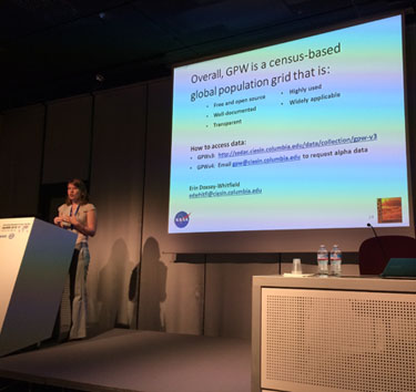
CIESIN geographic information specialist Erin Doxsey-Whitfield presents a technical overview of the development and methodology of Gridded Population of the World data product, soon to be released in its fourth version. IGARSS 2015, Milan, Italy, July 26–31. |
Alex de Sherbinin, CIESIN associate director for Science Applications, and Erin Doxsey-Whitfield, geographic information specialist, traveled to Milan, Italy, to participate in the International Geoscience and Remote Sensing Symposium 2015 (IGARSS 2015) July 26–31. Together with Prof. Ryuei Nishii of Kyushu University in Japan, de Sherbinin co-chaired two back-to-back sessions on remote sensing and population data integration for global change and disaster risk research. The sessions included an overview by de Sherbinin of work by the NASA Socioeconomic Data and Applications Center (SEDAC) to integrate remote sensing and population data, and a technical review of development and methods for the fourth version of the Gridded Population of the World (GPW) data set by Doxsey-Whitfield, co-authored with GIS programmer Kytt MacManus and research scientist Susana Adamo. Other session presenters included former visiting scholar Christopher Aubrecht of the Austrian Institute of Technology, as well as Nishii and Shojiro Tanaka of Hiroshima University of Economics. Prior to the IGARSS conference, Doxsey-Whitfield attended the 2015 International Summer School on Data Fusion for Risk Mapping, organized in Pavia July 23–24. Participation in the two IGARSS sessions was partially funded through a grant obtained by Nishii and Tanaka and administered by Kyushu University.
CIESIN Active at Esri Events in San Diego
July 27, 2015
|
|
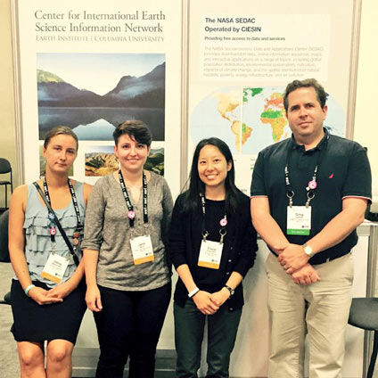
CIESIN staff introduce SEDAC products and services to visitors to the Nonprofit Showcase of the 2015 Esri User Conference, July 20–24 in San Diego, California. From left to right, geographic information specialists Olena Borkovska, Jane Mills, and Tricia Chai-Onn, and associate director for geospatial applications, Greg Yetman. |
CIESIN was well represented at two San Diego events organized by Esri: the National GIS Executive Forum (NGEF) July 18–19 and the 2015 Esri User Conference July 20–24. CIESIN deputy director Marc Levy participated in the NGEF, an invitation-only meeting at which senior geospatial industry executives discuss major trends shaping national mapping and geospatial data activities. He served on a panel exploring the themes of the meeting and gave a talk, “Data Needs for the Sustainable Development Goals: Implications for National Mapping.″
Following NGEF, an estimated 16,000 attendees from 132 countries gathered for the 2015 Esri User Conference, including Greg Yetman, CIESIN associate director for geospatial applications, and geographic information specialists Tricia Chai-Onn, Olena Borkovska, and Jane Mills. CIESIN was one of 45 aid, development, and conservation organizations invited to exhibit in the Nonprofit Showcase at the conference. The booth featured the new SEDAC Hazard Mapper, which visualizes data and map layers related to the exposure of population and infrastructure to selected natural hazards, as well as other data and services available from the NASA Socioeconomic Data and Applications Center (SEDAC) operated by CIESIN. In the demo theatre, Yetman gave a presentation on using SEDAC data and services in ArcGIS. He also presented a poster, “Spatial Disaggregation of Gridded Population Density Using Stable Night Light Brightness,” created with Lamont scientist Chris Small, Chris Elvidge and Kim Baugh of the NOAA National Centers for Environmental Information (NCEI), and CIESIN GIS programmer Kytt MacManus. Chai-Onn also presented a poster, co-authored with geographic information specialist Malanding Jaiteh, “Using GIS to Support Public Policy and Natural Resource Protection,” which was displayed in the Map Gallery on the opening day of the conference.
CIESIN has long used Esri software for the development and integration of SEDAC and other data sets. For Esri’s Landscape for Contributors group in ArcGIS Online, which has more than two million GIS data users, CIESIN has just published six new data layers on hazardous waste sites, global human footprint, emissions, roads, population, and the world's remaining wild areas. Additional layers will be added in coming months. Through its GIS Service Center, CIESIN hosts the Esri Columbia University Site License Program, which supplies Esri software, licenses, data, and technical support to schools, departments, and individuals at Columbia.
Call for Early Career Social Scientists Interested in Urban Big Data
July 24, 2015The International Social Science Council (ISSC) invites applications from outstanding early career social scientists around the world to become World Social Science Fellows and participate in the seminar, Big Data in an Urban Context, November 30–December 4, 2015, in Xiamen, China. The deadline for applications is August 24. The seminar will be hosted by the International Council of Science (ICSU) International Programme Office on Urban Health and Wellbeing at the Institute of Urban Environment (IUE), and is being organized in partnership with the ICSU Committee on Data for Science and Technology (CODATA). CIESIN research scientist Susana Adamo is one of three co-convenors of the seminar.
Earth Science Informatics Community Convenes in California
July 18, 2015Two recent meetings brought together members of the earth science informatics and user communities to Pacific Grove, California, to address key challenges in managing and utilizing earth science data. At DUG, the user group meeting of the Data Observation Network for Earth (DataONE) July 12–13, CIESIN senior digital archivist Robert Downs presented a poster on improving usability of earth science data. He then attended the summer meeting of the Federation of Earth Science Information Partners (ESIP) July 14–17, where he co-convened the session, “Citing a Black Box and its Content,” and gave several presentations on citation and usability issues. During the 2015 ESIP Education Workshop July 16, he presented on visualizing socioeconomic data in the classroom with the Climate and Health Analysis for Global Education Viewer (CHANGE Viewer). He also participated in a meeting of the Board of Directors of the Foundation for Earth Science. Greg Yetman, associate director of Geospatial Applications, gave a presentation on improving earthquake risk assessments for the reinsurance industry using remote sensing and socioeconomic data, based on a NASA-funded project led by ImageCat, Inc. He also participated in the session, “Developing and Emerging Standards, Practices, & Technologies,” giving brief remarks on geospatial data formats for developing and distributing data.
Science Community Meets in Paris to Consider Climate Change Futures
July 13, 2015In preparation for the upcoming Conference of the Parties to the United Nations Framework Convention on Climate Change (UNFCCC) in December, nearly two thousand scientists and policy experts met at UNESCO headquarters in Paris for the international scientific conference, Our Common Future Under Climate Change (CFCC), July 7–10. The conference highlighted scientific findings pertinent to ongoing international climate negotiations and emphasized the critical need for immediate action both to mitigate climate change and to begin implementing adaptation strategies. CIESIN director Robert Chen gave a presentation on the importance of integrated, policy-relevant indicators in helping to guide decision making related to climate change, co-authored with Alex de Sherbinin and Marc Levy, in a parallel session, “Quality and availability of data for global sustainability.” He also participated in a side event July 6, “Trusted Data Services to Support Climate Change Research,” where he presented on efforts by the NASA Socioeconomic Data and Applications Center (SEDAC) to support integration of natural, social, and health science data to enable both interdisciplinary science and practical applications. The side event was organized by the World Data System (WDS) of the International Council for Science (ICSU), the ICSU Committee on Data for Science and Technology (CODATA), the Research Data Alliance (RDA), and other partners, and was granted a “COP21 Label” by the government of France.
CIESIN Demographer Promoted to Research Scientist
July 8, 2015CIESIN is pleased to announce the appointment of demographer Susana Adamo as a research scientist beginning July 1. Adamo, who joined CIESIN's Science Applications Division in December 2007, is one of the project scientists for the NASA Socioeconomic Data and Applications Center (SEDAC) and co-leads the Population-Environment Research Network (PERN) hosted by CIESIN. Her research areas include climate and migration, vulnerability to hazards and climate change, and cross-disciplinary data integration. Adamo′s promotion recognizes her significant accomplishments in both science and practice, including service in international organizations and initiatives such as the Inter-American Institute for Global Change Research (IAI), the Integrated Research on Disaster Risk (IRDR) program, and the International Union for the Scientific Study of Population (IUSSP). A CIESIN committee chaired by Prof. Sally Findley of the Mailman School of Public Health conducted a rigorous review of her promotion case, in accordance with procedures established by the Earth Institute for practice-oriented scholars. The promotion was approved and endorsed by the Appointments Committee of the Earth Institute, the Earth Institute Faculty, and the Office of the Provost of Columbia University.
Adamo recently attended the 8th International Conference on Population Geographies (ICPG) in Brisbane, Australia, June 30–July 3. The biennial conference brought together population geographers and spatial demographers interested in the spatial dimensions of population processes, dynamics, and impacts. Adamo presented a paper co-authored with CIESIN senior research associate Paola Kim-Blanco, "Migrants in urban areas of developing countries: Understanding exposure and vulnerability in the context of global environmental change." She also chaired a session on climate and population dynamics.
International Experts on Use of Climate Data and Scenarios Meet at CIESIN
July 2, 2015
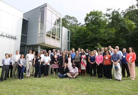
|
|
IPCC TGICA meeting participants gather on the lawn of the Comer Building, Lamont Campus, Palisades New York, June 30. The use of climate data and scenarios to support decision making was the focus of back-to-back international meetings hosted by CIESIN. |
The use of climate data and scenarios to support decision making was the focus of back-to-back international meetings hosted by CIESIN at Columbia's Lamont campus in Palisades, New York June 28–July 2. The meetings were organized by the Task Group on Data and Scenario Support for Impact and Climate Analysis (TGICA) of the Intergovernmental Panel on Climate Change (IPCC). On June 28–29, the TGICA held its 22nd meeting since its founding in 1996, addressing its ongoing responsibilities for managing the IPCC Data Distribution Centre (DDC) and continuing its efforts to develop guidance materials and other materials to facilitate access to and appropriate use of climate and socioeconomic data and information stemming from the IPCC assessments.
June 30–July 2, the TGICA organized an international expert meeting, "Decision-Centered Approaches to the use of Climate Information," which brought together more than 40 experts from around the world involved in using and producing climate-related data services. The specific objective of this expert meeting was to help guide and promote the appropriate application of new information emerging from the IPCC′s Fifth Assessment (AR5) released last year. The meeting included a guest lecture by Sabine Marx of Columbia's Center for Research on Environmental Decisions (CRED),“Decision Making under Uncertainty: A Social-Science Approach to Understanding and Improving the Use of Climate Information.″ CIESIN deputy director Marc Levy was one of the invited experts, and other CIESIN staff participated as observers.
CIESIN hosts the socioeconomic component of the IPCC DDC through the NASA Socioeconomic Data and Applications Center (SEDAC). CIESIN director Robert Chen has served as an ex officio member of the TGICA for more than 15 years.
Environmental Performance Discussed in Visit by Representatives of Togo
July 1, 2015A high-level delegation from the Republic of Togo met with CIESIN staff members at the Lamont campus June 29 to discuss environmental performance indicators issued by CIESIN in support of the Millennium Challenge Corporation (MCC). The delegation was led by His Excellency Limbiye Kadangha Bariki, the Ambassador of the Republic of Togo to the United States, and also included Stanislas Baba, minister-counselor in the presidency and director of the MCC Cell; Beguebouwe Paneto, director of studies in the Ministry of Planning; Simon Pierre Adouellande, consultant to the MCC Cell; and Ablamba Johnson, project analyst in the presidency. CIESIN updates the Natural Resource Protection Indicator (NRPI) and the Child Health Indicator (CHI) annually for the MCC, which is a grant-making arm of the U.S. government that provides development funding to low-income countries. MCC funding is conditional on national performance relative to 20 indicators in a range of good governance categories including ruling justly, investing in people, and encouraging economic freedom.
| 20 of 36 |