Building global partnerships to improve sharing and management of scientific data was the focus of the second plenary meeting of the Research Data Alliance (RDA), a new international initiative led by scientists and science agencies from the U.S., Europe, and Australia. Held at the National Academy of Sciences in Washington, DC, September 16–18, the meeting drew more than 350 experts from around the world to work on specific projects and develop new collaborations across a range of scientific disciplines. CIESIN director Robert Chen co-chaired a session on the legal interoperability of scientific data together with Paul Uhlir of the National Research Council and Enrique Alonso García, Counselor of State, Spain. CIESIN senior digital archivist Robert Downs and Chen also presented a poster, “Independent Evaluation of a Scientific Data Center for Compliance with the ISO 16363 Requirements for Audit and Certification of Trustworthy Digital Repositories.″
Resources »  News
News
| 28 of 36 |
Agriculture, Environment, and Livelihoods the Focus of Columbia Seminar
September 11, 2013A distinguished group of experts from around the world gathered in the rotunda of Columbia's Low Library for an all-day seminar, “The Nexus of Agriculture, Environment and Livelihoods,” marking the inauguration of the new Agriculture and Food Security Center (AFSC) within the Earth Institute. After a welcome by Columbia University president Lee Bollinger and Earth Institute executive director Steve Cohen, keynote speaker Akinwumi Adesina, Nigeria's minister of agriculture and rural development, gave an inspiring talk about the rapid progress transforming agriculture in Nigeria over the past two years, building on innovative approaches to sustainable agriculture and food security. AFSC director Pedro Sanchez and colleagues outlined the AFSC′s strategy for the future, which includes a strong emphasis on data and metrics for agricultural planning and decision making. CIESIN deputy director Marc Levy chaired a panel on integrating agricultural data, and senior staff associate Sonya Ahmed helped demonstrate the data and information resources available from the Africa Soil Information Service (AfSIS). The seminar also included remarks by Columbia′s provost, John Coatsworth; Earth Institute director Jeffrey Sachs; and Lamont-Doherty Earth Observatory director Sean Solomon.
Leader in Environmental Law Community Passes Away
August 30, 2013CIESIN notes with sadness the passing of Dr. Françoise Burhenne-Guilmin, head of the IUCN Environmental Law Center (ELC) in Bonn, Germany. Dr. Burhenne-Guilmin initiated the Environmental Law Information System (ELIS), which over the years evolved into the far more sophisticated online information system ECOLEX, the Gateway to Environmental Law. In 2000, CIESIN utilized ELIS in the development of the Environmental Treaties and Resource Indicators (ENTRI) Web application. Dr. Burhenne-Guilmin was a dedicated and tireless legal professional who will be missed by the environmental community.
NASA Invites Data Center Users to Evaluate Services and Support
August 29, 2013Every year NASA conducts a survey of users of the Earth Observing System Data and Information System (EOSDIS) to assess their satisfaction with the data, tools, and support provided by EOSDIS data centers. SEDAC, the Socioeconomic Data and Applications Center operated by CIESIN, is one of the centers evaluated by the Web-based survey. Registered SEDAC users should receive an e-mail invitation from CFI Group on behalf of NASA to provide feedback on the quality and utility of SEDAC products and services.
Please participate! Your feedback affects our future performance and helps us to identify and address user needs. Completing the anonymous questionnaire takes approximately 20 minutes. Optional comment fields are provided. If you are not currently a registered user, but would like to complete the survey, please contact SEDAC User Services.
We thank those who have participated in previous surveys and encourage you to provide feedback again this year! Your comments are useful as we continue to expand and improve SEDAC's data, services and web site.
EPA Holds Community Involvement Training in Boston
August 5, 2013Meredith Golden, CIESIN senior research associate, participated in the “2013 US EPA Community Involvement Training Conference″ and preconference “Superfund Monday,” organized by the U.S. Environmental Protection Agency (EPA) in Boston July 29–August 1. Golden provided a live technology demonstration and poster presentation on the NPL Superfund Footprint: Site, Population, and Environmental Characteristics Mapping Tool developed by CIESIN as part of the Columbia University NIEHS Superfund Research Program Research Translation Core. The Mapper was created for academic researchers, government regulators, and community stakeholders to help visualize critical data related to the area and inhabitants near Superfund sites in order to better assess the vulnerability of affected populations and to prioritize cleanups. Newly confirmed EPA Administrator Gina McCarthy gave the plenary presentation on the need for active community involvement in environmental policymaking and implementation. More than 400 EPA staff, agency stakeholders, and collaborative partners attended multiple workshops designed to enhance capacity to achieve these community involvement goals, with topics on best practices, innovative tools and technologies, and new software.
NASA Extends Socioeconomic Data Center Activities at CIESIN
August 1, 2013The integration of socioeconomic and remote sensing data to support both scientific research and societal applications continues to be an important element of the NASA Earth Observing System Data and Information System (EOSDIS). The NASA Goddard Space Flight Center (GSFC) has awarded CIESIN a follow-on contract effective August 1 to operate the NASA Socioeconomic Data and Applications Center (SEDAC) for another year, with the option of up to four additional years. CIESIN director Robert Chen will continue to serve as the SEDAC manager and principal investigator, along with deputy manager Alex de Sherbinin and system engineer Sri Vinay. SEDAC provides a range of socioeconomic and integrated data products and services to tens of thousands of users each month, with particular emphasis on the needs of geospatial data users, policy- and decision-makers, and those involved in research on the human dimensions of global change. SEDAC works closely with other EOSDIS data centers and with external partners and networks to facilitate access to and integration of data from a range of scientific disciplines to address pressing scientific and societal problems. Users may contact SEDAC's User Services office for information and assistance.
CIESIN Scientists Accept New Roles in Ecology and Global Change Research Institutions
July 30, 2013CIESIN associate research scientist Susana Adamo and director Robert Chen have been appointed to key management bodies of the Inter-American Institute for Global Change Research (IAI) and the National Ecological Observatory Network (NEON), respectively.
Adamo has begun a three-year term on the IAI Scientific Advisory Committee, which makes recommendations to the IAI's Conference of the Parties regarding the institute′s scientific agenda and its annual program and long-term plans, and also assesses the IAI′s research results. The committee is chaired by Frank E. Muller Karger of the University of South Florida and includes ten scientists representing a range of disciplines involved in global change research. Established in 1992, the IAI is an intergovernmental organization supported by 19 countries in the Americas that is working to increase the understanding of global change phenomena and their socio-economic implications.
Chen has been appointed for three years as an at-large member of the NEON Board of Directors, which is chaired by James P. Collins of Arizona State University. NEON, Inc. is a registered 501(c)(3) nonprofit organization solely funded by the U.S. National Science Foundation to enable understanding and forecasting of the impacts of climate change, land use change and invasive species on continental-scale ecology. NEON is currently in its construction phase, with the aim of establishing an operational observatory network in the 2017 time frame.
Biomass Burning and Climate Change Impacts Discussed in Recent Visits
July 24, 2013CIESIN recently hosted visits by Prof. Emilio Chuvieco from the Department of Geography and Geology, Universidad de Alcalá, Spain and Prof. Francisco Meza of the Pontificia Universidad Católica de Chile. Chieveco gave a “brownbag” lunch presentation July 23 on the subject of a global monitoring program for biomass burning. Meza, who is director of the Centro de Cambio Global at his university and co-director of AQUASEC, the Center of Excellence for Water Security of the Inter-American Institute for Global Change Research (IAI), met with CIESIN director Robert Chen and others July 17 to discuss areas of collaboration. Meza and Chen are both members of the Task Group on Data and Scenario Support for Impacts and Climate Analysis (TGICA) of the Intergovernmental Panel on Climate Change (IPCC).
Climate and Human Security to Be Addressed in Forthcoming IPCC Assessment
July 23, 2013CIESIN deputy director Marc Levy attended the final Lead Authors' Meeting of the Intergovernmental Panel on Climate Change (IPCC) Working Group II held in Bled, Slovenia July 14–18. Working Group II, which focuses on impacts, adaptation and vulnerability, is devoting a chapter to the topic of human security, including such issues as conflict, migration, employment, inequality, and indigenous peoples. As one of the chapter's lead authors, Levy spent the week with his co-authors evaluating responses to peer-review comments, coordinating with other chapter teams, and discussing final revisions to the chapter. The IPCC Fifth Assessment is expected to be released in spring 2014.
Targets for Reducing the Risks of Disasters Considered at UN Technical Meeting
July 19, 2013The human and economic toll of large-scale disasters is widely recognized, but in many parts of the world efforts to reduce disaster risks are limited and not well integrated into economic and social development. To help focus attention on the benefits of disaster risk reduction for sustainable development, a technical meeting “Targets and Indicators for Addressing Disaster Risk Management in the Post-2015 Development Agenda” was held in New York July 18–19. CIESIN senior staff associate Alex de Sherbinin gave a presentation on the use of indicators related to environmental performance and sustainability in policy and decision making. Director Robert Chen moderated a panel session on building the evidence base for key indicators and targets identified in the meeting breakout groups. Alliance Program intern Fannie Delavelle also participated in the meeting as a rapporteur.
The technical meeting was organized by the United Nations Development Programme, the United Nations Children's Fund, the United Nations Office for Disaster Risk Reduction, and the Global Facility for Disaster Reduction and Recovery. It aims to provide technical inputs on potential disaster-related targets and indicators to be incorporated into a new set of sustainable development goals that would supersede the current Millennium Development Goals in 2015.
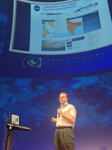
Chapel Hill Meetings Highlight Education and User Needs for Earth Observation Data
July 12, 2013
|
|
CIESIN senior digital archivist Robert Downs gives a presentation July 10 at the North Carolina Museum of Natural Sciences, on the SEDAC Population Estimation Service and data resources. 2013 ESIP Summer Meeting, Chapel Hill, North Carolina. |
Chapel Hill, North Carolina was the venue for back-to-back meetings addressing different aspects of the use of remote sensing and other environmental data in research, applications, and teaching. CIESIN senior digital archivist Robert Downs participated in the 2013 DataONE User Group Meeting July 7–8, where he presented a poster authored with CIESIN director Robert Chen, “Enabling Discovery and Use of Education and Professional Development Resources to Improve Geospatial Data Management and Preservation Practices.” As part of the meeting, he led a roundtable on data management planning.
Downs then joined the 2013 Summer Meeting of the Federation of Earth Science Information Partners (ESIP) July 9–12, where, in a special workshop for teachers, he gave a presentation on classroom use of the NASA Socioeconomic Data and Information Applications Center (SEDAC) Population Estimation Service. He also presented a second poster authored with Chen, “Measuring the Multidisciplinary Impact of Scientific Data Disseminated by the NASA SEDAC.” On July 10, Downs was one of the ESIP meeting attendees who shared their work at the North Carolina Museum of Natural Sciences, and on July 11 he gave another presentation on the topic of using SEDAC data to meet next-generation science education standards.
The ESIP Federation meeting was hosted by the University of North Carolina at Chapel Hill and the Renaissance Computing Initiative (RENCI). DataOne, the Data Observation Network for Earth, is one of the DataNet projects supported by the National Science Foundation; CIESIN is also a partner in a DataNet project led by the University of Minnesota, Terra Populus.
Virtual Lectures on Scenario Development/Sustainability Science Data Needs
June 28, 2013CIESIN deputy director Marc Levy and director Robert Chen gave virtual lectures June 27 to two different groups of scientists and scholars. Levy spoke to a distributed international network of health researchers involved in the Institute of Medicine (IOM) Innovation Collaborative on Global Environmental Health and Sustainable Development. He described the ongoing development of new socioeconomic and climate scenarios needed to assess the long-term implications of climate change, through a process coordinated with the Intergovernmental Panel on Climate Change (IPCC) Fifth Assessment Report (AR5). Chen gave an invited talk to more than 100 faculty, staff, students, and other guests at the Forum on the Future of Scientific Publishing: Open Access to Manuscripts & Big Data held at Stanford University in Palo Alto, California. His presentation addressed the need for sustainable, open access data in the rapidly expanding field of sustainability science.
Data Management, Analysis, and Visualization Addressed in U.S. Meetings
June 28, 2013CIESIN staff members recently participated in four meetings around the U.S. on different aspects of data management, analysis, and visualization. On June 16-20, senior staff associate Sonya Ahmed attended the 2013 National Cooperative Soil Survey (NCSS) National Conference in Annapolis, Maryland. She gave an overview of efforts to develop digital soils maps for Africa as part of the Africa Soil Information Service (AfSIS), a major initiative funded by the Bill and Melinda Gates Foundation.
On June 24-25 in Hampton, Virginia, senior research associate Alex de Sherbinin and senior media designer Al Pinto participated in a NASA technical meeting on data visualization and browse imagery for data from the Earth Observing Data and Information System (EOSDIS), including data from the Socioeconomic Data and Applications Center (SEDAC) operated by CIESIN. At the same time, CIESIN director Robert Chen traveled to Ann Arbor, Michigan to attend a workshop on "Sustaining Domain Repositories for Digital Data," organized by the Inter-university Consortium for Political and Social Research (ICPSR) at the University of Michigan and sponsored by the Alfred P. Sloan Foundation. He participated in a panel discussion on data infrastructure at national and international levels chaired by Sayeed Choudhury of Johns Hopkins University.
Further west, geographic information specialist Kytt MacManus attended the twelfth annual Scientific Computing with Python conference (SciPy 2013) June 24-28 in Austin, Texas. He gave a presentation on recent research activities at CIESIN to develop a uniform and efficient data structure for summarizing global geographic information.
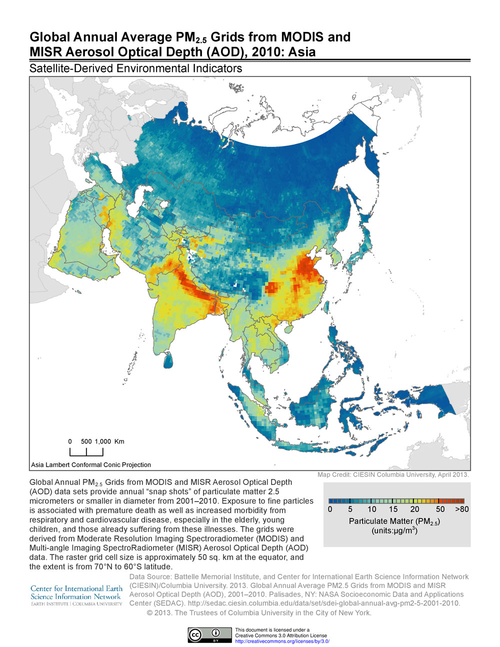
Satellites Help Monitor Air Pollution Around the World
June 26, 2013
|
Satellite observations are proving to be a valuable tool in assessing air pollution, specifically one of the worst pollutants, PM2.5 (microscopic particles smaller than 2.5 microns in diameter). Ground-based monitoring of this type of pollutant, which can lodge deep in lungs and may lead to respiratory and cardiovascular diseases, is expensive. Many countries lack the technical and financial resources to set up their own monitoring systems. Satellite monitoring, though less accurate than ground-based measurements, has the advantage of providing wall-to-wall coverage at relatively low cost.
Building on a model developed by researchers at Dalhousie University that estimates ground-based concentrations of PM2.5 from data on aerosol optical depth (AOD), a team from the Battelle Memorial Institute and CIESIN developed annual estimates of PM2.5 concentrations over a 10-year period on a global latitude-longitude grid. The AOD data were obtained from two different NASA instruments, the Moderate Resolution Imaging Spectroradiometer (MODIS) and the Multi-angle Imaging SpectroRadiometer (MISR).
The gridded data, developed by the NASA-funded project, "Using Satellite Data to Develop Environmental Indicators: An Application of NASA Data Products to Support High Level Decisions for National and International Environmental Protection," are the basis for environmental indicators designed to support health and environmental research and decision making. For example, they have been used in developing the particulate matter indicator of the 2012 Environmental Performance Index (EPI).
Exposure to high levels of PM2.5 is associated with premature death as well as increased morbidity from respiratory and cardiovascular disease, especially among the elderly, young children, and those already suffering from these illnesses. The World Health Organization guideline for PM2.5 average annual exposure is less than or equal to 10.0 micrograms per cubic meter, whereas the U.S. Environmental Protection Agency (EPA) primary standard is less than or equal to 12.0 micrograms per cubic meter.
Art-Science Collaboration Continues During Informal Visit
June 5, 2013Lars Jan, founding artistic director of Early Morning Opera, visited CIESIN in Palisades, New York June 4 to continue collaborative discussions started at the “Art and Science Dating Game,” which took place in March at the Metropolitan Museum of Art in New York City. Jan met again with CIESIN director Robert Chen as well as with other CIESIN and Earth Institute staff members to examine how various types of scientific data could be woven into Jan's new performance project, Holoscenes. Holoscenes is an ambitious effort to use water as a medium of expression about human-climate interactions on multiple time and space scales.
Jan gave an informal brown bag talk about his work to CIESIN and other staff at the Lamont campus. He was accompanied by Rasu Jilani, director of community programs at Mapp International Productions, which is producing Holoscenes. This art-science collaboration was facilitated by PositiveFeedback, an initiative of the Earth Institute, the Center for Creative Research at New York University, and the Institute for Sustainable Cities of the City University of New York.
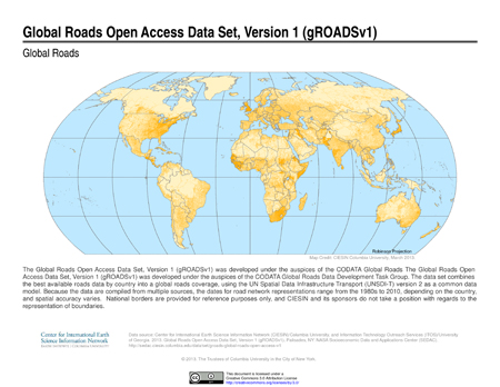
New Digital Roads Data Set Characterizes Intercity Road Networks Around the World
May 24, 2013
|
CIESIN has released a digital global data set on intercity roads, the Global Roads Open Access Data Set, Version 1 (gROADSv1). Developed under the auspices of the Global Roads Data Development Task Group of the Committee on Data for Science and Technology (CODATA) of the International Council for Science, gROADSv1 combines the best available open access data on roads between human settlements into a global roads coverage consistent with the United Nations Spatial Data Infrastructure Transport (UNSDI-T) version 2 data model.
This first version of the gROADS data set is part of a continuing effort to address the need among professionals in the humanitarian response, development, transportation, biodiversity conservation, and allied fields for free and open, spatially accurate, and readily updateable data on roads in order to better understand issues such as market access, cost of transportation, and human pressures on the environment. Data on road networks connecting human settlements may be especially valuable when used in conjunction with remote sensing and other spatial data to improve decision making related to urbanization and rural development. gROADSv1 is being distributed by the NASA Socioeconomic Data and Applications Center (SEDAC) operated by CIESIN, and represents an important step towards addressing the criteria established by the CODATA Task Group.
South Asia Urbanization and Transboundary River Basin Indicators the Focus of Two New Projects
May 23, 2013CIESIN has recently begun work on a new project funded by the World Bank to use night-time lights data to analyze growth patterns of South Asian cities over time. Cities in India, Pakistan, Afghanistan, Bangladesh, Sri Lanka, Nepal, Bhutan, and the Maldives with populations greater than 100,000 in the year 2000 have been mapped at two points in time, 1999 and 2010, and patterns of change in urban extent over the decade are being analyzed.
CIESIN has also joined an international team led by the UNEP-DHI Center for Water and Environment that is developing an assessment of transboundary river basins as part of the Global Environment Facility (GEF) Transboundary Water Assessment Program (TWAP). The overall purpose of the TWAP is to carry out a global comparison of approximately 200 transboundary river basins in order to improve understanding and management of current and future risks to both society and ecosystems at the river basin scale. The transboundary river basins component aims to develop quantitative indicators on a variety of dimensions, including water quantity, water quality, ecosystems, governance, and socioeconomic trends, for use by the GEF and other stakeholders. CIESIN′s role is to create indicators of economic activity, socioeconomic well-being, vulnerability to natural disasters, and dependence on water resources. Other team members include the International Union for Conservation of Nature (IUCN); Stockholm International Water Institute (SIWI); the Center for Environmental Systems Research (CESR) at the University of Kassel, Germany; the City University of New York (CUNY); and the Delta Alliance.
Population Estimation Map Client Now Available for Mobile Devices
May 22, 2013The NASA Socioeconomic Data and Applications Center (SEDAC) operated by CIESIN has released an update of its Population Estimation Service Map Client that now supports mobile devices such as tablets and smart phones. The new client uses version 3 of the Google Maps API to provide a user-friendly query interface to the SEDAC Population Estimation Service (PES), which is a standards-based Web service that provides an estimate of total 2005 population for a specific area of interest. The population estimates are based on the SEDAC Gridded Population of the World version 3 (GPWv3) data set. The new map client auto-detects screen size and automatically adjusts fonts and presentation to fit the device. Users are also now able to modify an existing polygon in order to refine their query, and to search for locations by name.
Data Needs for Understanding Urbanization and for Developing Climate Indicators Examined in Washington DC Meeting
May 10, 2013How remote sensing data from the NASA Earth observation satellites can be used in conjunction with socioeconomic data to improve assessment of urbanization patterns and trends was one of two main topics addressed in a technical interchange meeting organized by SEDAC, the NASA Socioeconomic Data and Applications Center operated by CIESIN, May 8–9 in Washington, D.C. The second topic was the potential role of NASA data centers like SEDAC in supporting the development of a system of indicators for the U.S. National Climate Assessment (NCA), a Congressionally-mandated assessment of climate change and its impacts in the United States.
As part of the meeting, two parallel breakout sessions were held with members from the SEDAC User Working Group (UWG) and the UWG of the Land Processes Distributed Active Archive Center (LP DAAC), to take advantage of their combined expertise and understanding of remote sensing and socioeconomic data. Experts from NASA, the NCA, other NASA data centers, and the World Bank also participated in person and by teleconference. Later in the meeting, SEDAC manager Robert Chen, deputy manager Alex de Sherbinin, and lead project scientist Marc Levy briefed the SEDAC UWG on recent activities and progress, including improvements to the SEDAC Web site and the expanding range of scientific citations of SEDAC data.
The SEDAC UWG is chaired by Molly Macauley of Resources for the Future. The UWG provides strategic advice and guidance to SEDAC and NASA and reviews SEDAC data development and dissemination plans.
New Online Resource Supports Learning About Scientific Data Management Practices
April 29, 2013CIESIN senior digital archivist Robert Downs created seven modules for the online learning resource, Data Management for Scientists Short Course, which was developed as a collaborative effort of the ESIP Commons, the knowledge repository of the Federation of the Earth Science Information Partners (ESIP). The short course aims to improve data management practices of scientists and data management professionals. Modules developed by Downs include Providing Access to Your Data: Access Mechanisms,” “Providing Access to Your Data: Determining Your Audience,” “Providing Access to Your Data: Rights,” “Responsible Data Use: Data Restrictions,” “Working with Your Archive: Broadening Your User Community,” “Providing Access to Your Data: Tracking Data Usage,” and “Providing Access to Your Data: Handling Sensitive Data.” All of the modules in the short course are freely available for use under a Creative Commons Attribution License, and may be used individually or combined to support instruction and learning on data management, dissemination, stewardship, and related issues.
| 28 of 36 |