Marine and Coastal Regions and Sea Level Rise
|
1 of 3
Prev
|
Next
|
MA Ecosystems, v1 (2000)Millennium Ecosystem Assessment (MA)To preserve access to the original ecosystems data used by the Millennium Ecosystem Assessment (MA) and other related research. |
Global Mangrove Forests Distribution, v1 (2000)Land Use and Land Cover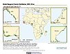
To provide data that can be used in global mangrove forest distribution modeling, land cover change analysis, global carbon accounting studies and to assist with policy-making in regards to human-environment interactions and future adaptive strategies. |
|
Urban-Rural Population and Land Area Estimates, v3 (1990, 2000, 2015)Low Elevation Coastal Zone (LECZ)
To provide estimates of urban and rural populations and land areas for the years 1990, 2000, 2015 for 234 countries and statistical areas with contiguous coastal elevations of less than or equal to 5m above sea level, 5-10m above sea level, and national totals using multiple updated data sources for comparative analysis. |
Sea Level Rise Impacts on Ramsar Wetlands of International Importance, v1 (
|
|
Urban-Rural Population and Land Area Estimates, v2 (1990, 2000, 2010, 2100)Low Elevation Coastal Zone (LECZ)
To provide estimates of urban and rural populations and land areas for the years 1990, 2000, and 2010; and projections to the year 2100 for 202 countries with contiguous coastal elevations in the following categories: less than or equal to 1m, 3m, 5m, 7m, 9m, 10m, 12m, or 20m; as well as national totals. |
Urban-Rural Population Estimates, v1 (1990, 1995, 2000)Low Elevation Coastal Zone (LECZ)
To provide estimates of urban and rural populations and land areas in the low elevation coastal zone. |
|
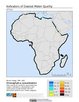
Annual Chlorophyll-a Concentration, v1 (
|
Change in Chlorophyll-a Concentration, v1 (
|
|
Coastlines, v3 (2000)Gridded Population of the World (GPW), v3To provide a set of coastlines consistent with GPWv3 raster data for cartographic purposes. |
Groundswell Spatial Population and Migration Projections at One-Eighth Degree According to SSPs and RCPs, v1 (
|
|
Groundswell Africa Spatial Population and Migration Projections at One-Eighth Degree According to SSPs and RCPs, v1 (
|
Delta Urban-Rural Population and Land Area Estimates, v1 (1990, 2000, 2014, 2015)Low Elevation Coastal Zone (LECZ)
To provide country-level estimates of populations and land areas in river delta- and non-delta contexts for the years 1990, 2000, 2014, and 2015 for 246 statistical areas, focusing on greater-risk zones using the global extent of low elevation zones contiguous to the coast bounded by either 5 meters or 10 meters. |
|
Subset of OpenStreetMap Roads, v1 (2014)West Africa Coastal Vulnerability MappingTo provide roads linking rural production to urban markets in the coastal zone of West Africa that represent an important exposed infrastructure asset. |
Subset of Global Mammal and Amphibian Richness Grids, 2015 Release (2013)West Africa Coastal Vulnerability MappingTo provide areas of higher richness of threatened species which may be at risk from climate stressors in the coastal zone of West Africa. |
|
Subset of High and Low Resolution Altimeter Corrected Elevations 2 (ACE2), v1 (
|
Social Vulnerability Indices, v1 (1997, 2005, 2008, 2010, 2013)West Africa Coastal Vulnerability MappingTo provide a measure of social vulnerability and "defenselessness" in the face of climate stressors in the coastal zone of West Africa. |
|
Subset of JRC Map of Accessibility, v1 (
|
Mangrove Forests Distribution Polygon, v1 (2000)West Africa Coastal Vulnerability MappingTo provide mangrove forests in the coastal zone of West Africa that may be exposed to the threats of sea level rise and storm surge. |
|
GPWv4 Population Growth Preliminary Release, v1 (
|
Population Projections, v1 (2030, 2050)West Africa Coastal Vulnerability MappingTo provide areas in West Africa that may be particularly exposed to climate stressors owing to future high population growth. |

|
1 of 3
Prev
|
Next
|