Marine and Coastal Regions and Sea Level Rise
| 2 of 3 |
GPWv4 Population Density Preliminary Release, v1 (2010)West Africa Coastal Vulnerability MappingTo provide areas in the coastal zone of West Africa that may be particularly exposed to climate stressors owing to high population density. |
Demographic and Health Survey Data Sets, v1 (
|
|
Gridded Subset of Sub-national Poverty and Extreme Poverty Prevalence, v1 (2005)West Africa Coastal Vulnerability MappingTo provide poverty levels in the coastal zone of West Africa. |
Deforestation, v1 (
|
|
Subset of DMSP-OLS Nighttime Lights for Economic Activity, v1 (2010)West Africa Coastal Vulnerability MappingTo provide a measure of economic activity in the coastal zone of West Africa based on nighttime lights. |
Commercial Crop Production, v1 (2000)West Africa Coastal Vulnerability MappingTo provide crop production for five higher-value export crops in West Africa to aid in estimating production value. |
|
Economic Systems Index, v1 (2000, 2010)West Africa Coastal Vulnerability MappingTo assess relative levels of economic activity in the coastal zone of West Africa. |
Point and Gridded Locations of Fatalities, v1 (
|
|
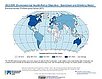
Environmental Performance Index, 2020 Release (
|
Environmental Performance Index, 2010 Release (
|
|
Environmental Performance Index and Pilot Trend Environmental Performance Index, 2012 Release (
|
Environmental Performance Index, 2014 Release (
|
|
Environmental Performance Index, 2016 Release (
|
Environmental Performance Index, 2018 Release (
|
|
Environmental Performance Index, 2008 Release (
|
Environmental Performance Index, 2022 Release (
|
|
U.S. Social Vulnerability Index Grids, v1.01 (2000, 2010, 2014, 2016, 2018, 2020)U.S. Census Grids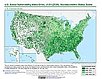
To provide a 1 km grid of the CDC Social Vulnerability Index (SVI) aligned with CIESIN's Gridded Population of the World, Version 4, Revision 11 (GPWv4.11) with a mask for water and no population. |
Fifth Assessment Report (AR5) Observed Climate Change Impacts, v2.01 (
|
|
Fourth Assessment Report (AR4) Observed Climate Change Impacts, v1 (
|
Complete Collection, v1.01 (
|
| 2 of 3 |