Environmental Sustainability Indicators and Trends
| 7 of 8 |
Global Cyclone Mortality Risks and Distribution, v1 (2000)Natural Disaster Hotspots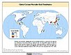
To provide a means of assessing global cyclone mortality risks and distribution. |
Global Volcano Mortality Risks and Distribution, v1 (2000)Natural Disaster Hotspots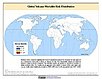
To provide a means of assessing global volcano mortality risks and distribution. |
|
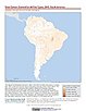
Global Cyclone Total Economic Loss Risk Deciles, v1 (2000)Natural Disaster Hotspots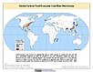
To provide a spatial surface of the total economic impacts of global cyclone hazard. |
Global Cyclone Proportional Economic Loss Risk Deciles, v1 (2000)Natural Disaster Hotspots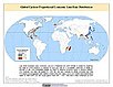
To provide a spatial surface of the proportional economic impacts of global cyclone hazard. |
|
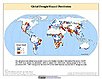
Global Earthquake Mortality Risks and Distribution, v1 (2000)Natural Disaster Hotspots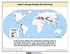
To provide a means of assessing global earthquake mortality risks and distribution. |
Global Flood Proportional Economic Loss Risk Deciles, v1 (2000)Natural Disaster Hotspots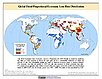
To provide a spatial surface of the proportional economic impacts of global flood hazard. |
|
Global Flood Mortality Risks and Distribution, v1 (2000)Natural Disaster Hotspots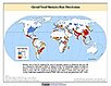
To provide a means of assessing global flood mortality risks and distribution. |
Global Earthquake Total Economic Loss Risk Deciles, v1 (2000)Natural Disaster Hotspots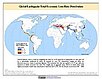
To provide a spatial surface of the total economic impacts of global earthquake hazard. |
|
Global Drought Hazard Frequency and Distribution, v1 (
|
Global Mangrove Forests Distribution, v1 (2000)Land Use and Land Cover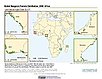
To provide data that can be used in global mangrove forest distribution modeling, land cover change analysis, global carbon accounting studies and to assist with policy-making in regards to human-environment interactions and future adaptive strategies. |
|
U.S. Climate Risk Projections by County, v1 (
|
Global Fire Emissions Indicators, Grids, v1 (
|
|
Global Human Footprint (Geographic), v1 (
|
Top One Percent Wild Areas (IGHP), v1 (
|
|
Global Human Footprint (IGHP), v1 (
|
Last of the Wild (IGHP), v1 (
|
|
Top One Percent Wild Areas (Geographic), v1 (
|
Last of the Wild (Geographic), v1 (
|
|
MA Ecosystems, v1 (2000)Millennium Ecosystem Assessment (MA)To preserve access to the original ecosystems data used by the Millennium Ecosystem Assessment (MA) and other related research. |
Global Fire Emissions Indicators, Country-Level Tabular Data, v1 (
|

| 7 of 8 |