Last of the Wild, v2
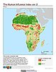
To provide an updated map of anthropogenic impacts on the environment in geographic projection which can be used in wildlife conservation planning, natural resource management, and research on human-environment interactions.
|
|
Last of the Wild, v2
To provide an updated map of anthropogenic impacts on the environment in Interrupted Goode Homolosine Projection which can be used in wildlife conservation planning, natural resource management, and research on human-environment interactions.
|
Last of the Wild, v2
To provide an updated map of anthropogenic impacts on the environment in the Interrupted Goode Homolosine Projection which can be used in wildlife conservation planning, natural resource management, and research on human-environment interactions.
|
|
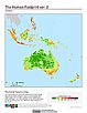
Last of the Wild, v2
To provide an updated map of wild areas in geographic projection which can be used in wildlife conservation planning, natural resource management, and research on human-environment interactions.
|
Last of the Wild, v2
To provide an updated map of anthropogenic impacts on the environment in geographic projection which can be used in wildlife conservation planning, natural resource management, and research on human-environment interactions.
|
|
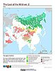
Last of the Wild, v2
To provide an updated map of wild areas in Interrupted Goode Homolosine Projection which can be used for wildlife conservation planning, natural resource management, and research on human-environment interactions.
|