Data Sets (117)
|
1 of 6
Prev
|
Next
|
Daily 8-Hour Maximum and Annual O3 Concentrations for the Contiguous United States, 1-km Grids, v1.10 (
|
Daily and Annual PM2.5 Concentrations for the Contiguous United States, 1-km Grids, v1.10 (
|
|
Daily and Annual NO2 Concentrations for the Contiguous United States, 1-km Grids, v1.10 (
|
Delta Urban-Rural Population and Land Area Estimates, v1 (1990, 2000, 2014, 2015)Low Elevation Coastal Zone (LECZ)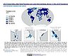
To provide country-level estimates of populations and land areas in river delta- and non-delta contexts for the years 1990, 2000, 2014, and 2015 for 246 statistical areas, focusing on greater-risk zones using the global extent of low elevation zones contiguous to the coast bounded by either 5 meters or 10 meters. |
|
Annual Mean PM2.5 Components (EC, NH4, NO3, OC, SO4) 50m Urban and 1km Non-Urban Area Grids for Contiguous U.S., v1 (
|
Annual Mean PM2.5 Components Trace Elements (TEs) 50m Urban and 1km Non-Urban Area Grids for Contiguous U.S., v1 (
|
|
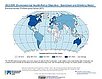
SDG Indicator 7.1.1: Access to Electricity, 2023 Release (
|
SDG Indicator 11.2.1: Urban Access to Public Transport, 2023 Release (
|
|
SDG Indicator 9.1.1: The Rural Access Index (RAI), 2023 Release (
|
SDG Indicator 11.7.1: Urban Public Space, Availability and Access, 2023 Release (
|
|
Global Database of Light-based Geospatial Income Inequality (LGII) Measures, v1 (
|
Sub-global Scenarios that Extend the Global SSP Narratives: Literature Database, v1 (
|
|
Natural Resource Protection and Child Health Indicators, 2023 Release (
|
Population, Landscape, And Climate Estimates (PLACE), v4 (2000, 2005, 2010, 2015, 2020)National Aggregates of Geospatial Data Collection (NAGDC)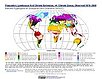
To provide tabular data to researchers without GIS capabilities who need data on population and land area by country across a range of physical characteristics. These include measures such as the number of persons living within coastal zones, the total area within a specific elevation strata, or the number of persons living within different climate zones. |
|
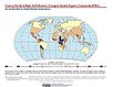
INFORM Global Risk Index 2019 Mid Year, v0.3.7, (2019)Intergovernmental Panel on Climate ChangeTo assess country-level vulnerability and coping capacity related to climate change based on the data set used in Chapter 8 of the Sixth Assessment Report (AR6) by the Intergovernmental Panel on Climate Change (IPCC) Working Group II (WGII). |
Daily and Annual NO2 Concentrations for the Contiguous United States, 1-km Grids, v1 (
|
|
Country Trends in Major Air Pollutants, v1 (
|
Environmental Performance Index, 2022 Release (
|
|
Natural Resource Protection and Child Health Indicators, 2022 Release (
|
Twentieth Century Crop Statistics, v1 (
|


|
1 of 6
Prev
|
Next
|