Alex de Sherbinin, CIESIN associate director for science applications and deputy manager of SEDAC, participated in an expert meeting, Land-Based Indicators for Sustainable Development Goal (SDG) Target 15.3, in Washington, DC, February 24–26. The meeting was convened by the United Nations Convention to Combat Desertification (UNCCD), the Convention on Biological Diversity (CBD), and the Food and Agriculture Organization of the United Nations (FAO) and co-hosted by the Scientific and Technical Advisory Panel of the Global Environment Facility (GEF-STAP). Participants focused on refining a proposed indicator of land degradation that will be presented at the forthcoming session of the Inter-Agency and Expert Group on Sustainable Development Goal Indicators (IAEG-SDGs) in Mexico City. This indicator would be complemented by additional data and indicators on land use/cover change, change in land productivity, and change in above- and below-ground carbon, that could also support reporting processes for the UNCCD, CBD, and GEF.
Resources »  News
News
| 18 of 36 |
CIESIN and Facebook Begin Collaboration on More Detailed Population Mapping
February 22, 2016CIESIN has begun working with Facebook’s Internet.org initiative to conduct systematic validation and quality assessment of high-resolution gridded population data, as announced by Facebook at the Mobile World Congress in Barcelona February 22. Last year, Facebook launched a project to utilize high-resolution (50-centimeter) remote sensing imagery in combination with the Gridded Population of the World version 4 (GPWv4) data set, to produce a 5-meter population map in order to better understand population and settlement patterns in rural areas of the developing world. Their main objective is to optimize strategies for extending Internet to these populations as part of the organization’s larger goal to bring connectivity to the four billion people who are not yet online. Recognizing the potential value of these data for a wide range of applications, Facebook decided to work with CIESIN to assess and improve the quality of the data. Facebook plans to make the new population distribution data for more than 20 developing countries openly available by summer 2016 and to continue expanding the data’s coverage to additional countries.
Mapping Climate Vulnerability: Annapolis Workshop Develops Best Practices
February 19, 2016A workshop on climate vulnerability and risk mapping and identifying best practices was held February 16 at the National Socio-Ecological Synthesis Center (SESYNC) in Annapolis, Maryland. Alex de Sherbinin, CIESIN associate director for science applications, organized the workshop, in which twelve scientists and two individuals from decision making communities worked together over three days to design a protocol for assessing existing studies, including outputs of method (conceptual models, data, and spatial analysis techniques) and mapping (clarity of communication and adherence to cartographic convention). The goal was to develop best practice guidelines for use in climate vulnerability and risk mapping. Such mapping is increasingly used for targeting adaptation programs and for local planning. Saleem Khan, visiting Fulbright-Nehru Fellow at CIESIN, was one of the participants in the workshop. SESYNC is funded by the U.S. National Science Foundation.
Approaches to Integrating OpenStreetMap and Global Roads Data Examined
February 12, 2016
|
|
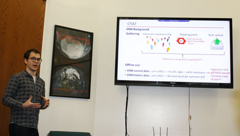
Bogdan-Mihai Cîrlugea discusses his work validating OpenStreetMap data for integration into the Global Roads Open Access Data Set (gROADS), at a presentation of his master's research February 11 at the Lamont Campus, Palisades, New York. |
A presentation, “Validation of OpenStreetMap for Integration into the gROADS v1,” was given by visiting staff associate Bogdan-Mihai Cîrlugea at the Lamont campus in Palisades, New York, February 11 at the conclusion of his five-month visit to CIESIN. Launched in 2004, OpenStreetMap (OSM) is the largest collaborative project to date to create free and editable cartographic data of the world. Cîrlugea’s work advances understanding about OSM's data structures and the potential advantages and limitations of using the OSM roads data set in geospatial research and applications. The work is the basis of Cîrlugea’s thesis for his master’s degree in environmental engineering, with a specialization in environmental modeling and monitoring, from l’École Polytechnique Fédérale de Lausannne (EPFL) in Switzerland. It is also a contribution to the work of an international task group of the Committee on Data for Science and Technology (CODATA) of the International Council for Science, which is developing a digital, publicly-available database of intercity roads, the Global Roads Open Access Data Set (gROADS). The current version of gROADS is available via the NASA Socioeconomic Data and Applications Center (SEDAC) operated by CIESIN.
Webinar Highlights Efforts to Validate OpenStreetMap Data
February 11, 2016CIESIN senior research associate Paola Kim-Blanco was one of two presenters in the February 10 webinar, “Crowdsourcing Data and Quality Control—The Experience of OpenStreetMap,” sponsored by the World Data System (WDS) of the International Council for Science (ICSU). Co-presenter Mikel Maron of the OpenStreet Map Foundation, Humanitarian OSM Team, and Mapbox described the evolution of approaches to providing guidance to members and of applying quality assurance/quality control methods to the data. Kim-Blanco summarized the literature on independent validation of the road and street data developed by more than 2.3 million registered OpenStreetMap (OSM) users, and reported on CIESIN’s efforts to validate intercity roads data in low-income countries. Launched in 2004, OSM is the largest crowd-sourced spatial data effort to date, having mapped more than 34 million kilometers of roads throughout the world. The Webinar was the eighth in a series organized by the WDS. The NASA Socioeconomic Data and Applications Center (SEDAC) operated by CIESIN is a regular member of the WDS.
Google Earth Engine Developers Hosted by CIESIN
February 5, 2016A team from Google Earth Engine, Google’s cloud platform for petabyte-scale analysis of satellite imagery and other geospatial data, visited CIESIN February 4–5 to provide training and discuss potential areas of collaboration. Tyler Erickson, Matt Hancher, and Allison Lieber met in the morning of February 4 with staff and researchers from CIESIN, the Lamont-Doherty Earth Observatory, and the International Research Institute for Climate and Society. That afternoon at the Comer Building, Hancher and Erickson led a public workshop tutorial on using Google Earth Engine. Hancher subsequently gave an evening presentation at Butler Library on Columbia's Morningside campus, in which he talked about the trends and technologies that have informed Google’s development of the Earth Engine platform over the past six years. On February 5, CIESIN director Robert Chen, deputy director Marc Levy, and associate director for geospatial applications Gregory Yetman met with Lieber and Rebecca Moore, Google's director of engineering for Google Earth, Earth Engine and Earth Outreach, to explore collaboration on population data access and integration. Originally conceived in 2009 as a platform for global forest monitoring, Earth Engine today is used by scientists, governments, and organizations around the world in diverse areas, ranging from food and water security to disaster risk management and public health to biodiversity and climate change adaptation.
CIESIN’s Meredith Golden Retires After Long Career in Environmental Health
February 3, 2016
|
|
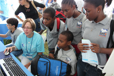
CIESIN senior research associate Meredith Golden demonstrates the National Priority List (NPL) Superfund Footprint Mapper at the Lamont-Doherty Open House in Palisades, New York, October 6, 2012. Before retiring, Golden led development of the mapping tool, with support from the National Institute of Environmental Health Sciences. |
After more than 35 years working in the field of environmental health, Meredith Golden, senior research associate at CIESIN, has retired. Golden joined the Consortium for International Earth Science Information Network in Saginaw, Michigan, 22 years ago, with a background in economics, medical geography, and epidemiology. She relocated to Columbia when CIESIN became an Earth Institute Center in 1998. She has served as a principal investigator of the National Institute of Environmental Health Sciences Columbia Superfund Research Program, leading the interdisciplinary Research Translation Core and coordinating development of the National Priorities List Superfund Footprint Mapper, a decision-making tool for researchers, regulators, and community partners. Golden also led the environment and health mission area of the NASA Socioeconomic Data and Applications Center and contributed to other CIESIN and Earth Institute activities on health and hazards. Going forward, Golden plans to continue to use her public health expertise in assisting communities in environmental education and hazard mitigation.
Moving from Talk to Action Urged in Planetary Security Presentation
February 2, 2016The post-1990 trend towards lower global insecurity is in reversal, with unanticipated and poorly managed climate shocks partly to blame, according to Marc Levy, CIESIN deputy director, in a presentation given in New York City January 25. The event, “Planetary Security: An Action Agenda on the Frontlines of Climate Change,” was hosted by the government of The Netherlands. Levy’s talk, “Time to Move from Talk to Action,” argued against scare tactics and overwhelming the public with large amounts of data. Among other recommendations, he called for the development of tools, techniques, and methods that drive effective action coalitions.
Latest Environmental Performance Index Released at World Economic Forum
February 1, 2016
|
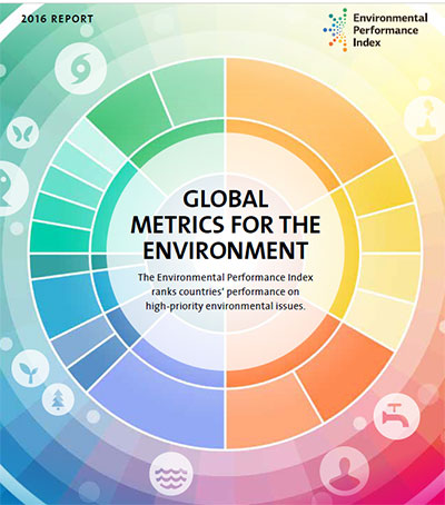
More deaths globally occur from poor air quality than from water, and more than half the world’s population is subject to unsafe air—these are some of the findings of the 2016 Performance Environmental Index (EPI) released January 23 at the annual meeting of the World Economic Forum in Davos, Switzerland. The biennial report, produced this year by the Yale Center for Environmental Law & Policy (YCELP), Yale Data-Driven Environmental Solutions Group at Yale University, and CIESIN, in collaboration with the Samuel Family Foundation, McCall MacBain Foundation, and the World Economic Forum, ranks country performance on high-priority environmental issues in two broad policy areas: protection of human health from environmental harm and protection of ecosystems. The 2016 EPI measures the performance of 180 countries in nine categories of environmental concern.
A major goal of the EPI is to organize the best available information to make it as relevant as possible. “Even when data exists, policymakers often struggle to apply this information appropriately,” notes Marc Levy, CIESIN deputy director. “The EPI works to identify and address these blind spots within existing policy goals. For instance, a new biodiversity indicator weeds out protected areas that do not intersect with species’ habitats, showing where national parks may be ineffective at protecting species.”
The 2016 version of the EPI awards Finland the top slot, followed by Iceland, Sweden, Denmark, and Slovenia. These five environmental leaders have policies that target protections to natural and built environments, with strong commitments to renewable energy. Finland’s top rank indicates its commitment to achieving a carbon-neutral society that will not exceed nature’s carrying capacity by 2050. Countries performing poorly—such as lowest ranked Somalia, Eritrea, Madagascar, Niger, and Afghanistan—are reminders that stable governance is necessary for effective environmental management and conflict disrupts environmental performance. Around one-third of countries that were scored on Climate and Energy are reducing their carbon intensity, and globally, trends in carbon intensity show a slight decline.
Access to Climate, Earth Science, and Social Science Data Addressed in Multiple Meetings
January 29, 2016Experts gathered in Geneva, Switzerland; Huntsville, Alabama; and Chapel Hill, North Carolina, for three different technical meetings addressing data access and management of scientific data related to climate change, remote sensing, and the social sciences. Alex de Sherbinin, associate director for science applications, participated in an experts meeting January 26–27 in Geneva, organized by the Intergovernmental Panel on Climate Change (IPCC) to examine the future role and activities of its Task Group on Data and Scenario Support for Impact and Climate Analysis (TGICA). The TGICA oversees the IPCC Data Distribution Center (DDC), which is co-managed by the British Atmospheric Data Center (BADC), the World Data Center-Climate in Germany, and the NASA Socioeconomic Data and Applications Center (SEDAC) operated by CIESIN.
At the same time in Huntsville, CIESIN director Robert Chen, in his capacity as manager of SEDAC, attended the annual meeting of the NASA Distributed Active Archive Center (DAAC) managers hosted by the Global Hydrology Resource Center (GHRC) DAAC at the University of Alabama in Huntsville. Together with NASA personnel from the Goddard Space Flight Center, the DAAC Managers planned cross-DAAC activities to improve the ability of users to seamlessly access, integrate, and analyze diverse Earth and social science data available from the NASA Earth Observing System Data and Information System (EOSDIS).
Chen subsequently traveled to the University of North Carolina at Chapel Hill for a workshop on public access to social science data, organized by the Minnesota Population Center (MPC) with support from the U.S. National Science Foundation (NSF). The workshop brought together more than 25 scientists and data experts from a diverse set of social science disciplines to develop recommendations to the NSF on how to improve data management plans and their implementation. Chen is a member of the workshop organizing committee that is drafting the workshop report and recommendations.
Geospatial Data Preservation and Climate Change Mitigation and Adaptation the Focus of New Publications
January 14, 2016Geospatial data management, curation, and preservation are the focus of three special issues of the Journal of Map & Geography Libraries, guest-edited by senior digital archivist Robert Downs. Due to a large number of high quality submissions, Downs and the editorial team were able to expand the original planned special issue into a sequence of three. The first issue, published in September 2015, contains an editorial by Downs, “Management, Curation, and Preservation of Geospatial Data: Introductory Perspectives,″ and six research articles. The second issue, published in December 2015, includes another introductory editorial, “Progress on the Management, Curation, and Preservation of Geospatial Data,″ and five more articles. The third special issue will be released in early 2016.
CIESIN research scientist Susana Adamo has published the opinion piece, “About Mitigation, Adaptation, and the UNFCCC’s 21st Conference of the Parties,” in REBEP-Revista Brasileira de Estudos de População. She argues for greater attention to linkages between mitigation and adaptation, and in particular to the role of population dynamics, in the context of international climate negotiations. Also appearing in the same journal is the paper, “Climate change and mitigation in the forestry sector: REDD+, national policies and local sustainable development in the Legal Amazon,″ by visiting senior research scientist Douglas Sathler, with Adamo and Everton Lima as co-authors.
- “Management, Curation, and Preservation of Geospatial Data: Introductory Perspectives″--Guest Editorial, First Special Issue, published September 2015, Volume 11, No. 2
- “Progress on the Management, Curation, and Preservation of Geospatial Data”--Guest Editorial, Second Special Issue, Volume 11, No. 3
- “About Mitigation, Adaptation, and the UNFCCC’s 21st Conference of the Parties”
- “Climate Change and Mitigation in the Forestry Sector: REDD+, National Policies, and Local Sustainable Development in the Legal Amazon”
New Population and Urbanization Data Released for Testing
January 12, 2016The NASA Socioeconomic Data and Applications Center (SEDAC) has released three new geospatial data products for external user testing.
The Global Urban Heat Island data set estimates the average land surface temperature within urban areas in degrees Celsius (summer daytime maximum and nighttime minimum), as well as the difference between those temperatures and the temperatures in surrounding rural areas, defined as a 10-kilometer buffer around the urban extent.
The Global Grid of Probabilities of Urban Expansion data set assesses likely future areas of urban expansion up to the year 2030. The projections are based on a model of global urban land-cover change developed by Karen C. Seto of Yale University, Burak Güneralp of Texas A&M University, and Lucy R. Hutyra of Boston University, described in a 2012 paper published in the Proceedings of the National Academy of Sciences.
The Gridded Population of the World, version 4 (GPWv4), data collection is the fourth version of SEDAC′s flagship data product, which models the global distribution of human population on a continuous surface. New features of GPWv4, which is expected to be released in production in early 2016, include more recent census data; a smaller grid size; and many more input census units.
Users are invited to submit comments and suggestions regarding these test versions of the data through the online “Feedback and Support″ link on the SEDAC Web site or by contacting SEDAC User Services at ciesin.info@ciesin.columbia.edu. A free Earthdata Login is now required to download data from SEDAC.
Earth Science Data Community Kicks off New Year in Washington DC
January 11, 2016The winter meeting of the Federation of Earth Science Information Partners (ESIP Federation) brought together more than 275 representatives of earth science data organizations at the Marriott Wardman Park in Washington DC January 6–8. The NASA Socioeconomic Data and Applications Center (SEDAC) was represented by CIESIN director and SEDAC manager Robert Chen and by senior digital archivist Robert Downs, who is also a member of the board of the Foundation for Earth Science. Downs participated in the ESIP Federation awards ceremony on January 6, introducing the winner of the Martha Maiden Lifetime Achievement Award for Service to the Earth Science Information Community, Ruth Duerr of the Ronin Institute for Independent Scholars. Downs also presented a poster, “Improving the Usability of Earth Science Data Products and Services by Enhancing Documentation.″ Chen gave a live demo of the recently released SEDAC Hazards Mapper as well as the HazPop mobile application currently under development in a session, “Trusted Data for Disaster Lifecycle Applications.″ On January 8, Downs summarized the activities of the Data Systems Integration Committee of the Earth Science Data System Working Group on Data Quality during the session, “Information Quality Cluster—Introduction, Reporting and Use Case Tutorial.″ He also led the development of use cases for the session, “Information Quality Cluster—Use Case Development Working Session.″
The ESIP Federation elected Emily Law of the NASA Jet Propulsion Laboratory as its new president, replacing outgoing president Peter Fox of the Rensselaer Polytechnic Institute. SEDAC has been a Federation “Type 1″ member since 1999.
Record Attendance at Fall American Geophysical Union Meeting
December 18, 2015More than 24,000 geoscientists from around the world gathered in San Francisco for the fall meeting of the American Geosphysical Union (AGU), the leading professional society in the earth sciences and related fields. CIESIN director Robert Chen, senior digital archivist Robert Downs, associate director for geospatial applications Greg Yetman, and Fulbright-Nehru postdoctoral Fellow Saleem Khan were among the attendees at the week-long event, December 14–18. Chen gave presentations on reference data layers for human population and built infrastructure and on monitoring the water-related sustainable development goals (SDGs). He also presented a poster on facilitating progress towards the SDGs through open data and indicators. Downs gave two oral presentations on data quality and data usability, presented posters on data curation and data interoperability, and helped convene or co-chair several sessions in the education, informatics, and public affairs tracks. He also served as a judge for student papers on informatics. Yetman gave an oral presentation on merging remote sensing and socioeconomic data for disaster risk assessment, and was a co-author, along with other CIESIN staff and external colleagues, of a paper presented by Philip Orton of Stevens Institute of Technology on flood adaptation mapping. Khan presented a poster on communicating sea level rise risks and adaptation strategies, which summarized his ongoing postdoctoral research at CIESIN.
Experts Provide Inputs to World Economic and Social Survey
December 15, 2015CIESIN research scientist Susana Adamo participated in an expert group meeting on the forthcoming World Economic and Social Survey 2016, “Building Resilience to Climate Change: An Opportunity to Reduce Inequality,” held in New York City December 10–11. Produced annually by the Development Policy and Analysis division of the United Nations Department of Economics and Social Affairs (UN DESA), the World Economic and Social Survey analyzes critical long-term social and economic development issues and the impacts of corresponding policies. Adamo was a discussant in the session, “Global Partnership for Building Climate-Resilient Development Pathways.” Designed to provide UN DESA with substantive advice in the preparation of the 2016 survey, the meeting brought together members of the UN DESA Team with experts from other UN organizations, academia, and research institutions. A second expert group meeting is planned in March 2016.
Estimating Child Mortality Focus of Technical Advisory Group Meeting
December 10, 2015The United Nations Inter-agency Group for Child Mortality Estimation (IGME) held a meeting of its independent Technical Advisory Group (TAG) at World Bank headquarters in Washington, D.C., December 8−9. Greg Yetman, CIESIN associate director for geospatial applications, gave an invited presentation on modeling global population distribution at the meeting, drawing on examples from the fourth version of the Gridded Population of the World data collection (GPWv4), to be released later this month through the NASA Socioeconomic Data and Applications Center (SEDAC). Spatially disaggregated estimates of population by age and gender are currently under development and will be released in 2016. The TAG provides guidance to the IGME on estimating infant and child mortality in support of Millennium Development Goal 4, the reduction of infant and child mortality.
Role of Data in Addressing Climate Change Highlighted in Paris
December 6, 2015This year′s 21st Conference of Parties (COP21) of the United Nations Framework Convention on Climate Change (UNFCCC), held in Paris for two weeks beginning November 30, was organized around the aim of achieving a legally binding and universal agreement to address the threat of climate change. CIESIN deputy director Marc Levy participated in four different events associated with COP21, highlighting the importance of data in dealing with climate security threats and building climate resilience. On December 4, he served on a panel, “The Science of Data Analytics for Climate Resilience,″ at a day-long side event hosted by the French Development Agency, ”Climate Change Resilience in the Age of Data.” He also gave a synthesis of the day′s discussion in the closing session. The following day he gave a talk on climate and security linkages at a side event hosted by the Netherlands Foreign Ministry, ”Planetary Security: Policy Action on the Impact of Climate on Security.” On December 7, he participated in two invitation-only workshops: ”Climate Open Data Roundtable,” hosted by the governments of Mexico and France and the Center for Open Data Enterprise; and ”How Can the Data Revolution Accelerate Climate Action?” held as part of ”Caring for Climate Business Forum.”
Social Scientists Explore Big Data in an Urban Context
December 5, 2015CIESIN research scientist Susana Adamo served as one of the convenors of the International Social Science Council (ISSC) World Social Science Fellows Seminar on “Big Data in an Urban Context” in Xiamen, China, November 30–December 4. The seminar brought together 19 Fellows from around the world to explore the opportunities and challenges of the emerging “big data” revolution for the social sciences. Adamo gave a short presentation, “Challenges of interdisciplinary data integration,” drawing on CIESIN's collaboration with the Minnesota Population Center to develop Terra Populus, a data service that integrates census and environmental data. The seminar was organized by the ISSC in partnership with the Committee on Data for Science and Technology (CODATA) of the International Council for Science (ICSU), and was hosted by the ICSU International Programme Office on Urban Health and Wellbeing at the Institute of Urban Environment (IUE) of the Chinese Academy of Sciences.
Articles Published on Climate Vulnerability Mapping and Sustainable Software
December 1, 2015CIESIN researchers have authored two new peer-reviewed journal articles. “Data Integration for Climate Vulnerability Mapping in West Africa” has been published in the ISPRS International Journal of Geo-Information, written by Alex de Sherbinin, associate director for science applications, with co-authors Tricia Chai-Onn, Malanding Jaiteh, and Linda Pistolesi, geographic information specialists; Valentina Mara, senior research associate; Emilie Schnarr, staff associate; and Sylwia Trzaska, associate research scientist. The article reports on vulnerability mapping efforts in West Africa conducted under the African and Latin American Resilience to Climate Change (ARCC) project of the U.S. Agency for International Development. By integrating climate, biophysical, and socioeconomic data in an overall vulnerability framework, vulnerability maps can be developed to help target adaptation and disaster risk management interventions. The paper draws on a range of data available from the NASA Socioeconomic Data and Applications Center (SEDAC) operated by CIESIN.
Robert Downs, senior digital archivist, is lead author of the article, “Community Recommendations for Sustainable Scientific Software,” appearing in the Journal of Open Research Software. Co-authors are former CIESIN associate director Chris Lenhardt of Renci, Erin Robinson of the Foundation for Earth Science, Ethan Davis of the University Corporation for Atmospheric Research, and Nicholas Weber of the University of lllinois at Urbana-Champaign. The paper summarizes outcomes of plenary and focus-group discussions on sustainable software held at the 2014 Summer Meeting of the Federation for Earth Science Information Partners (ESIP Federation) in Copper Mountain, Colorado.
Invited Talk Given on Vulnerability of Agriculture to Climate Change
November 30, 2015Senior research associate Pinki Mondal was an invited speaker at the conference, “Challenges and Significance of Ecosystem Research in Asia to Better Understand Climate Change,” at the Indian Institute of Tropical Meteorology in Pune, India, November 22–29. Mondal discussed how to decouple the spatial and temporal vulnerability of agricultural systems from future climate changes. The conference was sponsored jointly by AsiaFlux and the International Society for Photogrammetry and Remote Sensing (ISPRS).
| 18 of 36 |