The 21st Conference of Parties (COP21) of the United Nations Framework Convention on Climate Change (UNFCC) in Paris provided the context for the release of a new UNICEF report, Unless We Act Now: The Impact of Climate Change on Children, and the November 24 launch of an updated art installation, EXIT, presented by Fondation Cartier at the Palais de Tokyo. The UNICEF report utilized the soon-to-be-released fourth version of the Gridded Population of the World (GPWv4) data collection as the basis for a high-resolution child population map, which was then linked to a range of likely impacts of climate change on child health and wellbeing. EXIT also used updated data from GPWv4, as well as several other data sets from the NASA Socioeconomic Data and Applications Center operated by CIESIN, in an immersive, animated exhibit focused on contemporary human migration and the potential implications of climate change. EXIT was developed by the design studio Diller Scofidio + Renfro in collaboration with Columbia faculty members Mark Hansen, Laura Kurgan, and Ben Rubin. The original version was part of the exhibition “Native Land: Stop Eject″ held at the Fondation Cartier in 2008, and was subsequently shown at COP15 in Copenhagen.
Resources »  News
News
| 19 of 36 |
2015 El Niἦo Event Examined at Lamont Conference
November 25, 2015The climate phenomenon known as the “El Niἦo″ that is currently affecting weather and climate conditions around the globe was the focus of the El Niἦo 2015 Conference held at the Lamont campus November 17–18. More than 100 representatives from academia, government, nongovernmental organizations, and the private sector gathered to discuss the prospects for an unusually intense El Niἦo this year and its potential socioeconomic impacts. CIESIN deputy director Marc Levy gave an invited plenary talk, “El Niἦo in the Context of Global Change: Implications for Risk,” highlighting the many socioeconomic and environmental changes that are likely to influence how the 2015 El Niἦo impacts society on regional to global scales. The conference was jointly organized by the International Research Institute for Climate and Society (IRI), the World Meteorological Organization (WMO), the U.S. Agency for International Development, and the U.S. National Oceanic and Atmospheric Administration. A video of Levy’s talk is available.
Geography 2050 Symposium Explores Our Urban Future
November 24, 2015
|
|
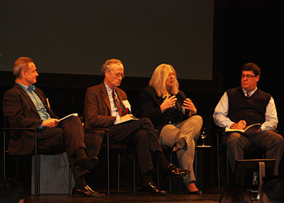
Keynote speaker Susan Gordon, deputy director of the National Geospatial-Intelligence Agency (second from right), with moderator Keith Masback of the U.S. Geospatial Intelligence Foundation (far right) and commentators Lee Schwartz, the Geographer of the United States (far left), and Alexander Murphy of the University of Oregon (second from left), in a panel at the Geography 2050 symposium, “Future Role of Cities in the Geo-Strategic Landscape.″ New York City, November 20. |
Following up on the first Geography 2050 Symposium held in 2014, the Earth Institute again partnered with the American Geographical Society (AGS) to host “Geography 2050: Exploring Our Future in an Urbanized World” November 19–20 at Columbia University’s Lerner Hall in New York City. More than 250 participants from government, industry, academia, and the non-profit sector participated in a series of thematic panels and sessions addressing the diverse processes reshaping the world′s cities. CIESIN director Robert Chen moderated a plenary panel, “Cities at Risk of Disaster″ that included speakers Cynthia Rosenzweig of the NASA Goddard Institute for Space Studies (GISS) and Jacob Rosengarten, chief enterprise officer with the XL Catlin Group. The Symposium featured keynote speakers Joan Clos, executive director of the United Nations Human Settlements Programme (UN-Habitat), and Susan Gordon, deputy director of the National Geospatial-Intelligence Agency (NGA). The AGS has recently named three new honorary fellows, including Earth Institute director Jeffrey Sachs and Jesse Ausubel of the Rockefeller University. Other Geography 2050 partners were the Open Geospatial Consortium and the U.S. Geospatial Intelligence Foundation and sponsors included Boundless, Esri, HumanGeo, MapStory, the Rockefeller Foundation, and Spatial Networks. Chen also participated in the AGS Council’s annual meeting held in Low Library November 21, where he was re-elected to a full 3-year term.
Collaborative Strategies for Sustained Environmental Data Management
November 20, 2015Senior digital archivist Robert Downs was among an interdisciplinary group of data curators, environmental and computer scientists, tool developers, and data aggregators attending the Collaborative Strategies for Sustained Environmental Data Management workshop November 17–19 at Arizona State University in Tempe, Arizona. Sponsored by the National Science Foundation, the workshop explored strategies for data repositories to collaborate and facilitate the continuing management and usability of environmental data to accelerate scientific inquiry, including perspectives from both interdisciplinary and domain repositories. Kerstin Lehnert, senior research scientist at the Lamont-Doherty Earth Observatory, also participated in the workshop.
NASA Webinar Features Hazard Mapping Tools
November 19, 2015The recently released SEDAC Hazards Mapper was the subject of a Webinar on November 18, one in a series of NASA Earthdata Webinars. Greg Yetman, associate director for geospatial applications at CIESIN, demonstrated the Hazards Mapper, a simple, online tool for estimating the number of people living near hazardous events as well as human settlements and major facilities such as dams and nuclear power plants. Developed by the NASA Socioeconomic Data and Applications Center (SEDAC) operated by CIESIN, the Hazards Mapper displays near-real-time data on earthquakes, fires, air quality, and, for the U.S., flood and tornado warnings. Yetman also demonstrated a preliminary version of the HazPop app, an iPhone- and iPad-compatible app expected to be released next year. The HazPop app supports many of the features of the Hazards Mapper and also takes advantage of location services available with mobile phones and tablets. A recording of the webinar, the third offered by SEDAC, is now available on YouTube.
Group on Earth Observations Establishes New Ten-Year Strategy
November 13, 2015The Group on Earth Observations (GEO) held its twelfth Plenary Meeting (GEO-XII) and Ministerial Summit in Mexico City November 9–13. CIESIN director Robert Chen and associate director for science applications Alex de Sherbinin participated in the plenary and several side events as members of the delegation from the Committee on Data for Science and Technology (CODATA), which is a GEO Participating Organization. Chen provided an overview of the new thematic network on sustainable development data established by the UN Sustainable Development Solutions Network (SDSN) at a side event November 10, “Sustainable Development Goals: Earth Observations in Service of Global Development.″ Another side event, the “Benefits of Data Sharing,” featured a presentation by de Sherbinin, “Data Sharing for the Sustainable Development Goals (SDGs).” The ministerial meeting affirmed GEO support for implementation of the SDGs and approved the GEO Strategic Plan for 2016–2025. Established in 2005, GEO is a voluntary partnership of governments and organizations.
Digital Resource Preservation Focus of Chapel Hill Conference
November 6, 2015CIESIN senior digital archivist Robert Downs joined other archivists, librarians, and computer scientists to discuss ways to improve infrastructure and capabilities for the long-term preservation of digital resources at the 12th International Conference on Digital Preservation (iPRES2015) hosted by the University of North Carolina at Chapel Hill (UNC) November 2–6. During the plenary session November 2, Downs provided a summary of the standard for bodies providing audit and certification of candidate trustworthy digital repositories developed by the International Organization for Standardization (ISO 16919:2014). The following day he presented a lightning talk and a poster, “Establishing Trustworthy Repositories of Scientific Data: Opportunities and Benefits.″ The poster was authored with Ruth Duerr of the Ronin Institute for Independent Scholarship, Devan Ray Donaldson of Indiana University, and Sarah Ramdeen of UNC. For a workshop November 6, “Using Open-Source Tools to Fulfill Digital Preservation Requirements,″ he gave a lightning talk on open source software challenges.
Communication Tools for Hazards and Sea Level Rise Highlighted
November 6, 2015The new SEDAC Hazards Mapper and a prototype iOs mobile app called HazPop were the focus of a presentation by CIESIN associate director for information technology Sri Vinay and application developers Al Pinto and Frank Pascuzzi at a systems engineering meeting at the NASA Goddard Space Flight Center in Greenbelt, Maryland, November 3–5. These new tools provide users with the ability to monitor selected hazards such as earthquakes and fires in near-real time in conjunction with information on population and infrastructure.
At the Rising Seas Summit in Boston, also November 3–5, CIESIN postdoctoral research fellow Saleem Khan gave an invited talk, “Public Health Implications of Climate Change and Sea-level Rise.” Khan described a tool he is developing, Communicating Risk of Sea-level Rise and Engaging Stakeholders in Framing Community-based Adaptation Strategies (COREDAR), and its potential role in health care infrastructure, community health, organizational planning, and climate projection and response management. The Summit was organized by the Association of Climate Change Officers (ACCO) to explore the interrelationships between sea level rise, climate change and extreme events.
Remote Sensing Enables Mapping of Urban Infrastructure and Population
November 5, 2015Greg Yetman, associate director for geospatial applications, gave a presentation on mapping infrastructure and population for disaster planning in urban areas using remote sensing and census data, at the Mapping Urban Areas from Space (MUAS) conference November 4–5 in Frascati, Italy. Organized by the European Space Agency (ESA), the conference provided a forum for scientists and data users to present results from ongoing research and application development activities using data from past and current satellites. Yetman′s presentation was based on collaborative work with ImageCat, Inc. under projects funded by NASA and the World Bank. Lamont research professor Christopher Small, who serves as one of the project scientists for the NASA Socioeconomic Data and Applications Center (SEDAC) operated by CIESIN, also presented on mapping human settlements.
“Data Diplomacy” Discussed at New York Workshop
October 30, 2015The political and social dimensions of data collection and sharing was the theme of the Data Diplomacy Workshop October 28–29 at the New York Academy of Medicine in New York City. CIESIN senior digital archivist Robert Downs co-moderated a discussion on data curation and access and gave a presentation, “Data Diplomacy Considerations for the Data Curation Lifecycle.” The workshop was organized by the University of Rochester and sponsored by the Worldwide Universities Network (WUN), in collaboration with the Committee on Data for Science and Technology (CODATA) and the World Data System (WDS) of the International Council for Science (ICSU) and others.
International Climate Data Task Group Meets in Cape Town
October 29, 2015The twenty-third meeting of the Task Group on Data and Scenario Support for Impact and Climate Analysis (TGICA) of the Intergovernmental Panel on Climate Change (IPCC) was held October 26–28 in Kalk Bay, Cape Town, South Africa. CIESIN director Robert Chen participated in the meeting as an ex officio member of the TGICA, in his capacity as co-manager of the IPCC Data Distribution Centre (DDC). The TGICA is working to make key data sets from the Fifth Assessment Report (AR5) available through the DDC and to provide guidance information and other resources to facilitate access to and use of data and scenarios by the international community. The meeting was hosted by the University of Cape Town and included a special session on South African data and scenario needs.
Best Practices for Data Rescue Discussed at Pennsylvania State Archives
October 21, 2015CIESIN′s senior digital archivist, Robert Downs, attended the Best Practices Exchange 2015 at The State Museum of Pennsylvania in Harrisburg October 20, where he co-convened the session, “Rescuing Early Digital Assets and Preserving Data Rescue Capabilities,” with Christopher Muller of Muller Media Conversions. During the session, Downs described a number of data rescue efforts conducted by the NASA Socioeconomic Data and Applications Center (SEDAC) over the past two decades, including data from early Intergovernmental Panel on Climate Change (IPCC) assessments and the Millennium Ecosystem Assessment (MA). The Best Practices Exchange is an online community for librarians, archivists, records managers and other information professionals dedicated to managing digital information in government and non-government settings.
Nansen Initiative Sets Protection Agenda for Displaced Persons
October 14, 2015CIESIN research scientist Susana Adamo participated in the Nansen Initiative Global Consultation October 12–13 in Geneva, Switzerland, as a member of the Consultative Committee. Hosted by the Governments of the Swiss Confederation and the Kingdom of Norway, the Consultation brought together more than 350 delegates, including government ministers and officials from over 100 countries as well as representatives of 13 international and non-governmental organizations and more than 35 academic and civil society institutions. The Consultation reviewed and endorsed a non-binding Agenda for the Protection of Cross-Border Displaced Persons in the Context of Disasters and Climate Change. The Protection Agenda articulates three priorities: collecting data and enhancing knowledge; enhancing the use of humanitarian protection measures; and strengthening the management of disaster displacement risk in the country of origin. Adamo and CIESIN associate director for science applications, Alex de Sherbinin, contributed to a number of previous regional and civil society meetings that led up to the Global Consultation, which marked the end of the Nansen Initiative in its current form.
Vision for a Digital Earth Highlighted at International Conference
October 10, 2015Nearly 500 scientists, engineers, technologists, and environmental managers from around the world gathered in Halifax, Nova Scotia, October 5–9 for the 9th Symposium of the International Society for Digital Earth. Greg Yetman, CIESIN associate director for geospatial applications, gave a talk on modeling the distribution of global human population in a session on the human dimensions of a “digital Earth.” The conference facilitated the sharing of concepts, research findings, technologies, and practical applications supporting the digital Earth vision, with a particular focus on applications related to Nova Scotian expertise in ocean and atmospheric sciences.
Eye on Earth Alliance Commits to Supporting Sustainable Development Goals
October 9, 2015
|
|
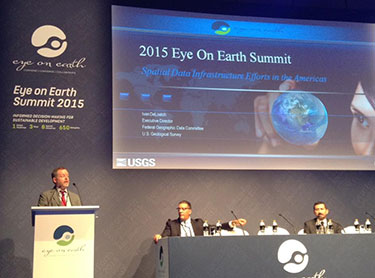
CIESIN deputy director Marc Levy moderated a side event, “Enabling the Data Revolution in the Americas” at the Eye on Earth Summit 2015 held in Abu Dhabi October 6-8. |
Abu Dhabi in the United Arab Emirates was the venue October 6–8 for the Eye on Earth Summit 2015, an international conference organized by the Eye on Earth Alliance to address the global challenge of increasing access to information to support sustainable development. CIESIN director Robert Chen and deputy director Marc Levy participated actively in the Summit, highlighting CIESIN′s experience in interdisciplinary data integration and indicator development and contributing to the Summit′s outcome statement. Chen moderated a session, “Innovations in Data Supply: Big Data and How to Manage It.″ Levy gave a presentation, “Data Needs for the Sustainable Development Goals: Preparing for Pluralism.″ He also moderated a panel, “Data Integration for Effective Monitoring of the Sustainable Development Goals,” and chaired a side event, “Enabling the Data Revolution in the Americas.”
The Eye on Earth Alliance is an international coalition led by five organizations: the Environment Agency-Abu Dhabi (EAD) through the Abu Dhabi Global Environmental Data Initiative (AGEDI); the United Nations Environment Programme (UNEP); the Group on Earth Observations (GEO); the International Union for Conservation of Nature (IUCN) ; and the World Resources Institute (WRI). At the conclusion of the Summit, the Alliance committed to “guarantee the free and open access to environmental and societal data” and to “assist and guide the global community in meeting the Sustainable Development Goals.”
Population Modeling and Mobile Phone Data Topic of Talk at CIESIN
October 8, 2015Andrew Tatem, director of the WorldPop project and the Flowminder Foundation, visited CIESIN October 7 for a presentation on mapping population distributions and characteristics at high spatial and temporal resolutions. Tatem, who is also an associate professor of geography at the University of Southhampton, England, gave an overview of the WorldPop project, which aims to provide an open access archive of spatial demographic data sets for Central and South America, Africa, and Asia. WorldPop supports development, disaster response, and health applications through the provision of detailed and open access modeled population distribution data sets built using open and peer-reviewed methods. Flowminder focuses on analysis of mobile phone data to reap insights into population dynamics.
Demographic Evidence Base for Development Reviewed
October 7, 2015Alex de Sherbinin, CIESIN associate director for science applications, and research scientist Susana Adamo were part of an expert group meeting convened by the United Nations Population Division October 5–6 at United Nations headquarters in New York City. The meeting, “Strengthening the Demographic Evidence Base for the Post-2015 Development Agenda,” was organized to inform a report by the UN Secretary General to be presented to the 49th session of the Commission on Population and Development (CPD) in April 2016. The meeting reviewed the ability of typical sources of demographic data, such as censuses, surveys, civil registration and vital statistics systems, and administrative records, to meet the needs of the 2030 Sustainable Development Agenda recently adopted by the UN General Assembly. Experts were asked to consider how new types of data might complement more traditional data sources. Adamo and de Sherbinin presented a note, “CIESIN’s Experience Mapping Population and Poverty,” to session six of the meeting, “Data disaggregation and utilization challenges: Prospects for the integration of multiple data sources to produce estimates for different geographical scales and time periods.”
Second Geography 2050 Symposium to Focus on Our Future Urbanized World
October 2, 2015The American Geographical Society (AGS) is again partnering with the Earth Institute and other organizations to hold its Fall Symposium, “Geography 2050: Exploring Our Future in an Urbanized World,” at the Columbia University Morningside Heights campus November 19–20. The symposium will bring together leaders from diverse sectors of business, government, science, and education for discussion and debate about the implications of radically changing geographies of urban habitats over the next few decades. Featured speakers include Joan Clos, executive director of UN-Habitat; Lee Schwartz, the geographer of the United States; Audrey Singer, Senior Fellow with the Brookings Metropolitan Policy Program; and Jeffrey Sachs, director of the Earth Institute. CIESIN director Robert Chen will moderate a session, “Cities at Risk of Disaster.″
Historic Global Partnership on Sustainable Development Data Launched
September 30, 2015On September 27 in New York City, the 193 Member-States of the United Nations committed to meeting 17 Sustainable Development Goals (SDGs) by the year 2030. The following day, the Global Partnership for Sustainable Development Data was launched, a multi-stakeholder group consisting of governments, civil society, private sector, international organizations, academic, statistical and data communities, and networks. The Partnership aims to work together to strengthen inclusivity, trust, and innovation in the way that data are used to address sustainable development. CIESIN is one of more than 70 “Champions″ that have made specific commitments to further the work of the Partnership in key areas, including improving the effective use of data, filling key data gaps, expanding data literacy and capacity, increasing data openness, and mobilizing political will and resources. At the launch event, CIESIN director Robert Chen gave a one-minute commitment statement on behalf of both CIESIN and the Group on Earth Observations (GEO). CIESIN has begun working with GEO, the UN Sustainable Development Solutions Network (SDSN), and other Champions to ensure that the vast expertise, data resources, and capabilities of the science and Earth Observations communities will be integrated into efforts to develop and implement SDG indicators and to support sustainable development data needs at all levels of decision making.
Events at Columbia Highlight New Sustainable Development Agenda
September 24, 2015A major international conference and several working meetings were held at the Columbia University Morningside Heights campus September 23–24 in the lead-up to the United Nations (UN) Sustainable Development Summit 2015 on September 25–27, just prior to the UN General Assembly meeting. The 2015 International Conference on Sustainable Development brought together a range of world leaders with more than 1500 stakeholders from government, academia, international agencies, nongovernmental organizations, and grassroots organizers to share practical solutions for the achievement of more sustainable and inclusive societies. CIESIN director Robert Chen moderated a plenary panel, “Monitoring the SDGs: Are OECD Countries Ready?,″ which included ambassadors from the U.S. and Germany and other experts on measurement of progress towards the Sustainable Development Goals (SDGs). Deputy director Marc Levy gave a presentation, “Planetary Boundaries and Peacebuilding: Separating Myth from Reality,” in a parallel session on planetary boundaries.
In conjunction with the conference, the new thematic group, Data for Sustainable Development, established by the UN Sustainable Development Solutions Network (SDSN), met for the first time, co-chaired by Enrique Giovanni, University of Rome Tor Vergata; Shaida Baidee, Open Data Watch; and Chen. Levy and senior program manager Alex Fischer also participated in the meeting, outlining initial plans for specific project activities to be carried out under the auspices of the thematic group. Chen also participated in part of the SDSN Leadership Council meeting on September 24, to help report on the plans for the data group. The SDSN Leadership Council acts as the board of the SDSN and includes eminent experts on sustainable development from academia, business, civil society, and the public sector from around the world.
| 19 of 36 |