lan
|
3 of 3
Prev
|
Next
|
ATSDR Hazardous Waste Site Polygon Data with CIESIN Modifications, v2 (2010)Superfund Site FootprintsTo provide an easily accessible, corrected data set of polygons for hazardous waste sites in the United States which can be used to identify nearby populations and assess their potential risk. |
Global Fire Emissions Indicators, Country-Level Tabular Data, v1 (
|
|
MA Biodiversity, v1 (
|
MA Scenarios, v1 (
|
|
Central American Vegetation/Land Cover Classification and Conservation Status, v1 (
|
||
China Maps Bibliographic Database, v1 (
|
||
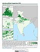
India Annual Winter Cropped Area, v1 (
|
India Village-Level Geospatial Socio-Economic Data Set, v1 (1991, 2001)India Data Collection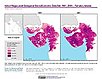
To provide data that can be used in independent spatial statistical analyses, construction of development-related indices, or in combination with remote sensing data in order to identify spatio-temporal patterns and/or changes in different demographic categories, such as male, female, urban, rural, level of education, etc. |
|
Global Human Built-up And Settlement Extent (HBASE) Dataset From Landsat, v1 (2010)Global High Resolution Urban Data from Landsat
To provide high spatial resolution estimates of global urban extent derived from global 30m Landsat satellite data for the target year 2010 and a companion dataset to the Global Man-made Impervious Surface (GMIS) dataset. |
Global Man-made Impervious Surface (GMIS) Dataset From Landsat, v1 (2010)Global High Resolution Urban Data from Landsat
To provide high spatial resolution estimates of global man-made imperviousness for the target year 2010, derived from global 30m Landsat satellite data and a companion dataset to the Global Human Built-up And Settlement Extent (HBASE) dataset. |
|
U.S. EPA National Priorities List Sites with CIESIN Modifications, v2 (2014)Superfund Site Footprints
To provide an easily accessible, corrected EPA data set of the geo-referenced locations displayed as points for all the National Priorities List (NPL) Superfund sites in the United States, Puerto Rico, and other territories. |
SDG Indicator 11.7.1: Urban Public Space, Availability and Access, 2023 Release (
|
|
Yale Center for Earth Observation (YCEO) Surface Urban Heat Islands, v4 (
|
Sub-global Scenarios that Extend the Global SSP Narratives: Literature Database, v1 (
|
|
Global Urban Polygons and Points Dataset (GUPPD), v1 (
|

|
3 of 3
Prev
|
Next
|