Land Use and Land Cover Change
| 2 of 3 |
MA Climate and Land Cover, v1 (
|
MA Ecosystems, v1 (2000)Millennium Ecosystem Assessment (MA)To preserve access to the original ecosystems data used by the Millennium Ecosystem Assessment (MA) and other related research. |
|
Subset of High and Low Resolution Altimeter Corrected Elevations 2 (ACE2), v1 (
|
||
MA Scenarios, v1 (
|
Central American Vegetation/Land Cover Classification and Conservation Status, v1 (
|
|
Global Human Built-up And Settlement Extent (HBASE) Dataset From Landsat, v1 (2010)Global High Resolution Urban Data from Landsat
To provide high spatial resolution estimates of global urban extent derived from global 30m Landsat satellite data for the target year 2010 and a companion dataset to the Global Man-made Impervious Surface (GMIS) dataset. |
Global Man-made Impervious Surface (GMIS) Dataset From Landsat, v1 (2010)Global High Resolution Urban Data from Landsat
To provide high spatial resolution estimates of global man-made imperviousness for the target year 2010, derived from global 30m Landsat satellite data and a companion dataset to the Global Human Built-up And Settlement Extent (HBASE) dataset. |
|
Dams, v1.01 (2011)Global Reservoir and Dam (GRanD), v1
To provide a geographically explicit and reliable database of dams for the scientific community. |
Global Urban Heat Island (UHI) Data Set, v1 (2013)Satellite-Derived Environmental Indicators
To provide a global data set of average summer daytime maximum/nighttime minimum land surface temperatures (LSTs) for urban extents, as well as the LST difference between the urban area and the buffer. |
|
Global Fire Emissions Indicators, Grids, v1 (
|
Global Summer Land Surface Temperature (LST) Grids, v1 (2013)Satellite-Derived Environmental Indicators
To provide raster representations of global summer daytime maximum and nighttime minimum surface temperature for studies related to human health and climate change. |
|
Reservoirs, v1.01 (2011)Global Reservoir and Dam (GRanD), v1
To provide a geographically explicit and reliable database of reservoirs for the scientific community. |
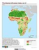
Global Human Influence Index (Geographic), v2 (
|
|
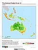
Global Human Footprint (IGHP), v2 (
|
Global Human Influence Index (IGHP), v2 (
|
|
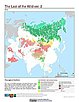
Last of the Wild (Geographic), v2 (
|
Global Human Footprint (Geographic), v2 (
|
|
Last of the Wild (IGHP), v2 (
|
SSPs Literature Database, v1 (
|
| 2 of 3 |