Poverty Mapping
To provide a global gridded relative deprivation index characterizing the levels of multidimensional deprivation in each pixel at ~1 km resolution.
|
|
Poverty Mapping
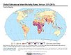
To provide a global subnational map of infant mortality rate estimates for the year 2015, to be used by a wide user community in interdisciplinary studies of health, poverty, and the environment.
|
Poverty Mapping
To provide high spatial resolution subnational estimates of unsatisfied basic needs for use by a wide community for interdisciplinary studies of poverty, inequality and the environment.
|
|
Poverty Mapping
To provide high spatial resolution subnational estimates of poverty and inequality for use by a wide user community for interdisciplinary studies of poverty, inequality and the environment.
|
Poverty Mapping
To provide a global subnational map of the prevalence of underweight children that can be used by a wide user community in interdisciplinary studies of health, poverty and the environment.
|
|
Poverty Mapping
To provide high spatial resolution subnational estimates of poverty and food security for use by a wide community for interdisciplinary studies of poverty, food security and the environment.
|
Poverty Mapping
To provide a global subnational map of infant mortality rate estimates that can be used by a wide user community in interdisciplinary studies of health, poverty and the environment.
|
|